


-
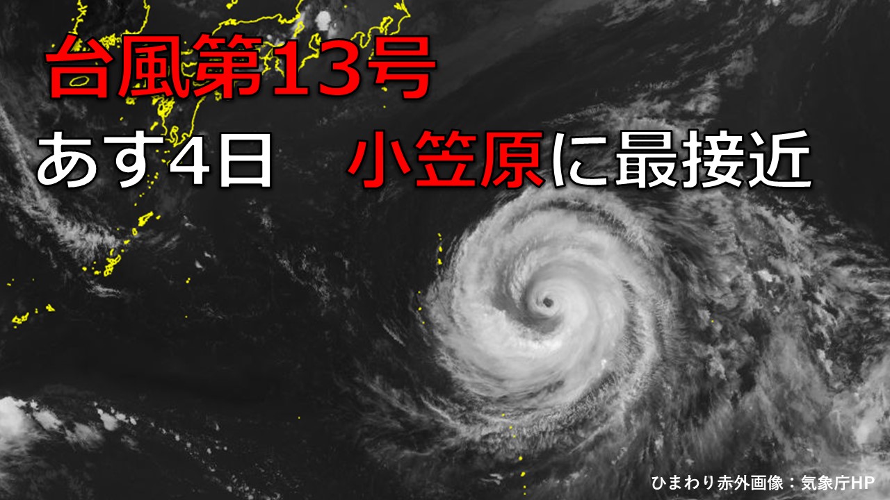
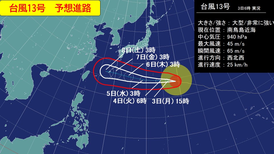
[Typhoon information] Large and extremely strong typhoon No. 13 will make its closest approach to the Ogasawara Islands on tomorrow 4th
2026/08/03 18:23
-
As of 3:00 p.m. today, Monday, March 3,
large and extremely strong typhoon No. 13 is located near Ogasawara and is moving west-northwest with a stormy area at a speed of approximately 25 kilometers per hour.
The central pressure is 945hPa and the maximum wind speed near the center is 45m/s
The maximum instantaneous wind speed is 60m/s.
Typhoon No. 13 is expected to approach the Ogasawara Islands with extremely strong force accompanied by stormy winds from
4th (Tuesday) to 5th (Wednesday).
In the Ogasawara Islands, heavy rain accompanied by thunder is expected to occur in some places from the morning of the 4th until the early evening of the 4th.
In addition, extremely strong winds will blow from late tonight until the 5th, and from midday to early afternoon on the 4th, there will be strong winds in some areas that could cause injuries from flying objects or overturn trucks.
Maximum wind speed expected on the 3rd (maximum instantaneous wind speed)
Ogasawara Islands 20 meters (30 meters)
Maximum wind speed expected on the 4th (maximum instantaneous wind speed)
Ogasawara Islands 30 meters (45 meters)
Maximum wind speed (maximum instantaneous wind speed) expected on the 5th
Ogasawara Islands 23 meters (35 meters)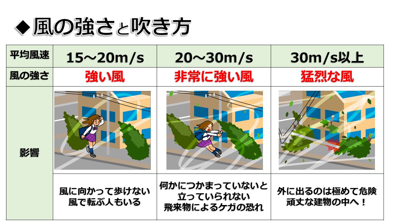
Please refrain from going out unless necessary, and stay away from windows when indoors to avoid strong winds.
Please pay attention to the latest information that will be announced in the future.
-
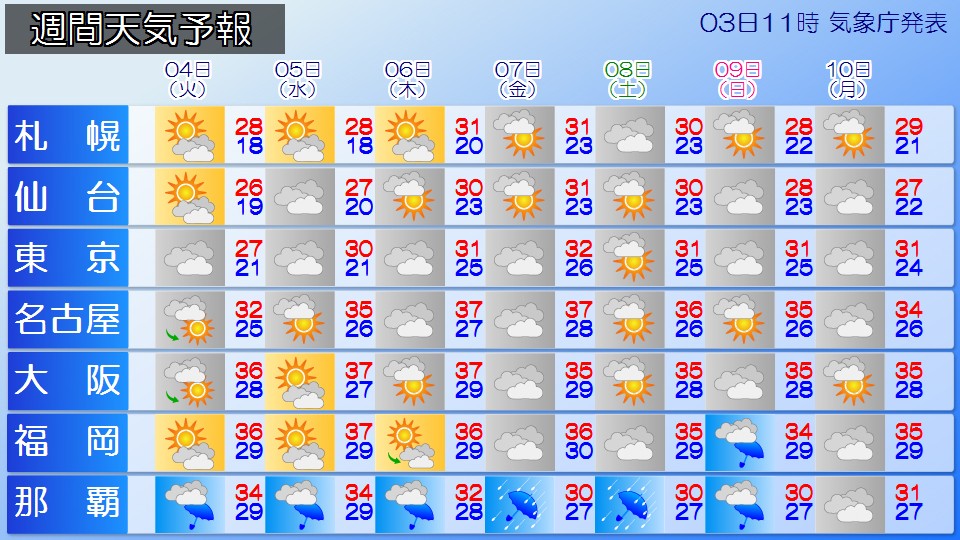
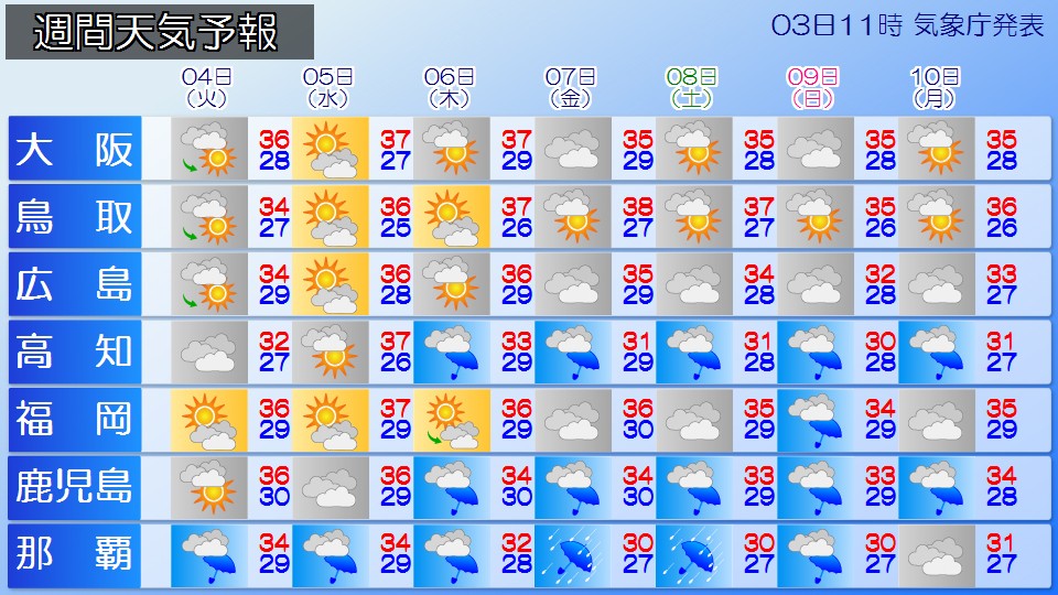
Weather for the week: Ogasawara Islands, Okinawa and Amami will experience heavy rain as Typhoon No. 13 approaches
2026/08/03 17:22
-
The weather for the next week is expected to be very stormy as Typhoon No. 13 approaches the Ogasawara Islands around the 4th (Tuesday), and then approaches Okinawa and Amami around the 6th (Thursday) and 7th (Friday). Please check the latest typhoon information and prepare early.
It is expected that there will be many rainy days on the Pacific side of western Japan due to the influence of typhoons.
In northern and eastern Japan, the heat will calm down a bit, with moist easterly winds blowing on the Pacific side and clouds spreading on many days.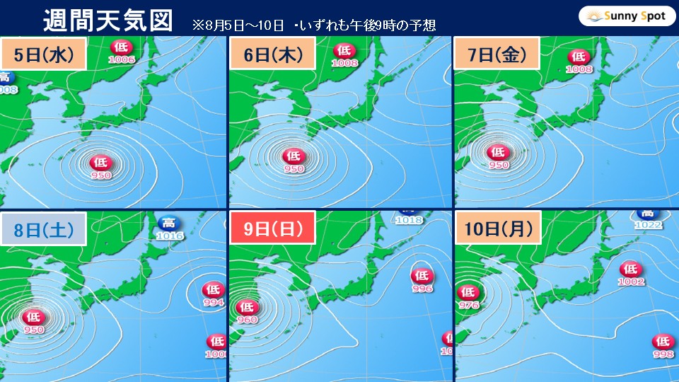
Large and extremely strong Typhoon No. 13 is currently near Ogasawara, moving west-northwest at a speed of approximately 25 kilometers per hour. It is expected to approach the Ogasawara Islands around the 4th tomorrow (Tuesday), while remaining very strong. In the Ogasawara Islands, please be on high alert for high waves with swells until the 5th (Wednesday), and be careful of strong winds and landslides from the 4th (Tuesday) to the 5th (Wednesday).
Please be wary of high waves accompanied by swells from the 4th (Tuesday) to the 5th (Wednesday) in the southern part of the Izu Islands.
Typhoon No. 13 is expected to approach Okinawa/Amami with strong force from the 6th (Thursday) to the 7th (Friday). In Okinawa and Amami, there will be heavy rain and storm surge, and depending on the path of the typhoon, there will be warning-level heavy rain and storm surge. Please take early measures to prepare for disasters such as storms and heavy rain.
Western Japan will also be affected by the typhoon and will experience rain starting around the 6th (Thursday), mainly on the Pacific side.
In Kumamoto Prefecture, which suffered damage from the recent earthquake, the intense heat is likely to continue even on cloudy and rainy days. For those involved in recovery work and those living in evacuation areas, please take precautions against heat stroke by hydrating frequently. There is also the possibility of rain and wind effects from Typhoon No. 13 in the future, so please check the latest weather forecast.
Even in areas far away from the typhoon, waves are high especially on the Pacific side, so caution is required when enjoying sea activities.
In northern and eastern Japan, moist easterly winds will blow on the Pacific side, and clouds will likely spread. There will be little sunlight, and the heat will calm down a bit in areas such as the Kanto region, so although it is not expected to be an extremely hot day, it will still feel hot and humid. Please continue to take precautions against heatstroke. On the other hand, the sun will reach the Sea of Japan side, making it extremely hot.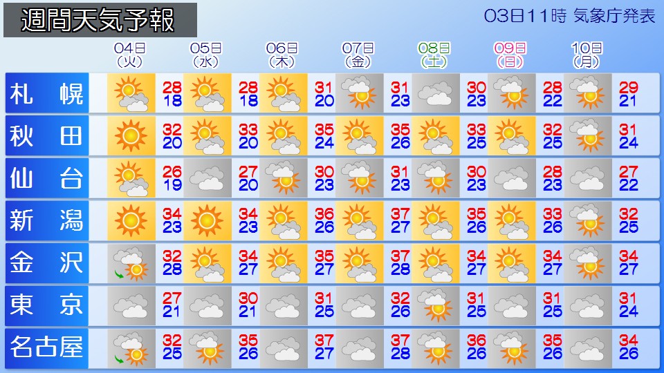
-
[Typhoon No. 13] A large and extremely strong typhoon No. 13 will approach the Ogasawara Islands through tomorrow 4th, and then Okinawa. Expected to approach Amami
2026/08/03 07:16
-
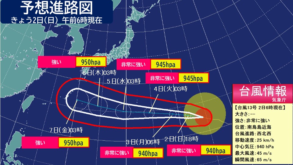
As of 6 a.m. today, the 3rd (Monday), a large and very strong typhoon No. 13 is moving westward in the waters near Minamitorishima.
#Typhoon No. 13 3rd (Mon) 6:00 am
==================
Size Large
Force Very strong
Center location Near Minamitorishima
Movement speed West-northwest 25km/h
Central pressure 940hPa
Maximum wind speed 45m/s (near the center)
Maximum instantaneous wind speed 65m/s
==================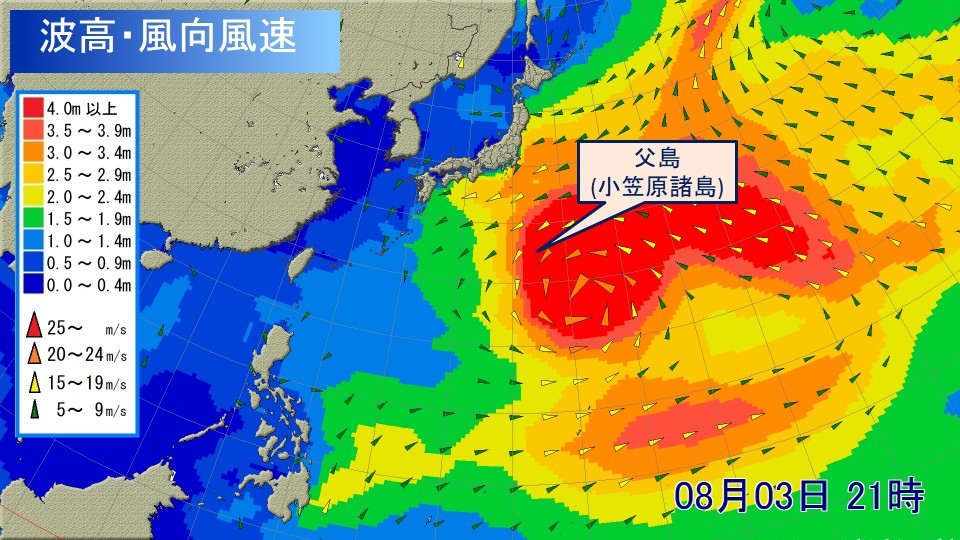
Typhoon No. 13 is expected to continue moving westward, and in the Ogasawara Islands, heavy storms are expected from today, and the winds will gradually become stronger. Tomorrow, the 4th (Tuesday), is expected to be a stormy day, and there is a risk that the waves could reach 11 meters in height with the swell. Please be extremely cautious of strong winds and high waves.
Also, depending on the degree of development of rain clouds, there is a risk of heavy rain reaching warning level. Please take precautions against landslides and flooding of low-lying areas.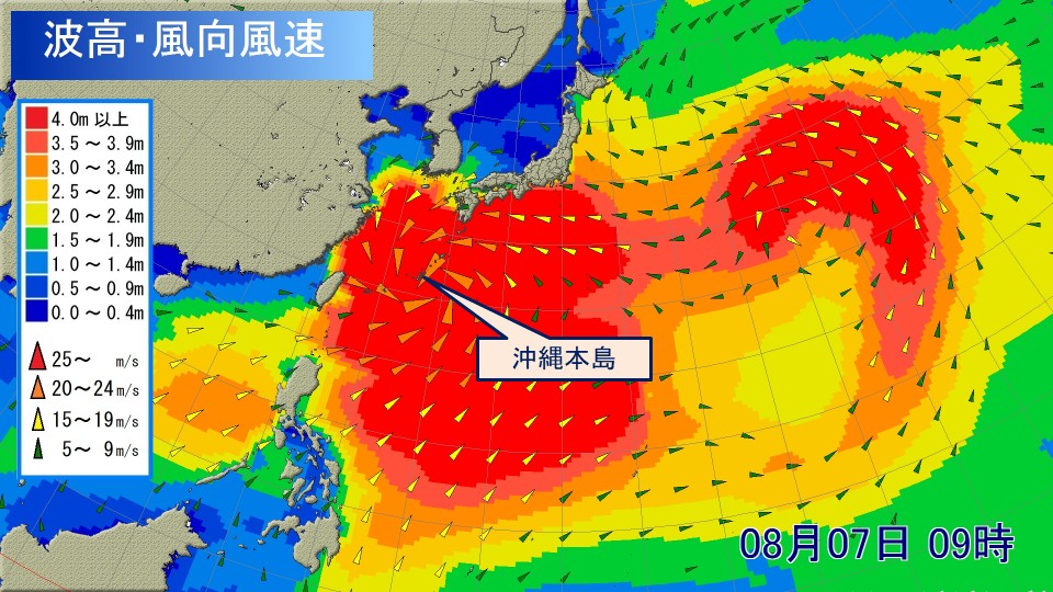
After that, Typhoon No. 13 is not expected to lose much strength, and is expected to approach Okinawa with strong force around the 7th (Friday). Okinawa/Amami is expected to experience heavy rain and stormy weather from around the 5th to the 7th, and depending on the path of the typhoon, warning-level heavy rain and storm surge are expected.
Please pay attention to the latest typhoon information that will be updated in the future and prepare early.
#Wave forecast (Ogasawara Islands)
Wave height expected on the 3rd
Ogasawara Islands 8 meters with swells
Wave height expected on the 4th
Ogasawara Islands 11 meters with swells
Estimated wave height
Ogasawara Islands 9 meters with swells
#Wind forecast (Ogasawara Islands)
Maximum wind speed (maximum instantaneous wind speed) expected on the 3rd
Ogasawara Islands 20 meters (30 meters)
Expected on the 4th Maximum wind speed expected on the 5th (maximum instantaneous wind speed)
Ogasawara Islands 25 meters (35 meters)
Maximum wind speed expected on the 5th (maximum instantaneous wind speed)
Ogasawara Islands 23 meters (35 meters)
#Rain forecast (Ogasawara Islands)
The expected 24-hour precipitation from 6:00 on the 4th to 6:00 on the 5th is high in the Ogasawara Islands, 120 mm
Then, the 24-hour rainfall expected from 6:00 on the 5th to 6:00 on the 6th is high in the Ogasawara Islands,
Ogasawara Islands: 80 mm.
-
Weather forecast for today, the 3rd (Monday): Be careful of dangerous heat and sudden changes in the weather from the afternoon from the Tokai to the west. Typhoon No. 13 approaches the Ogasawara Islands
2026/08/03 06:43
-
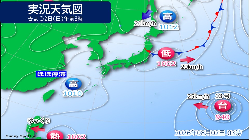
Today, the 3rd (Monday), the area around Honshu will be covered in high pressure. The weather front is expected to move away over the eastern seaboard, and the weather is expected to improve in the Tohoku region. In Tohoku and Hokuriku, there may be an announcement that the rainy season is over.
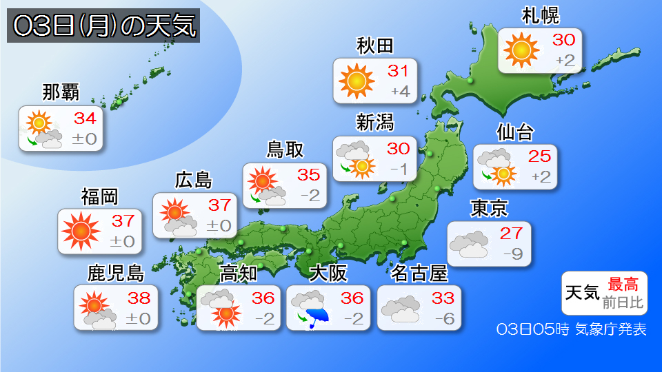
The Pacific side of eastern Japan is expected to be cooler in many places due to the influence of cold and humid air from the northeast. The expected maximum temperature in Tokyo is 27 degrees Celsius, which is expected to be below normal. However, clouds tend to spread around the Kanto region and there are places where it rains, so it would be a good idea to bring a foldable umbrella.
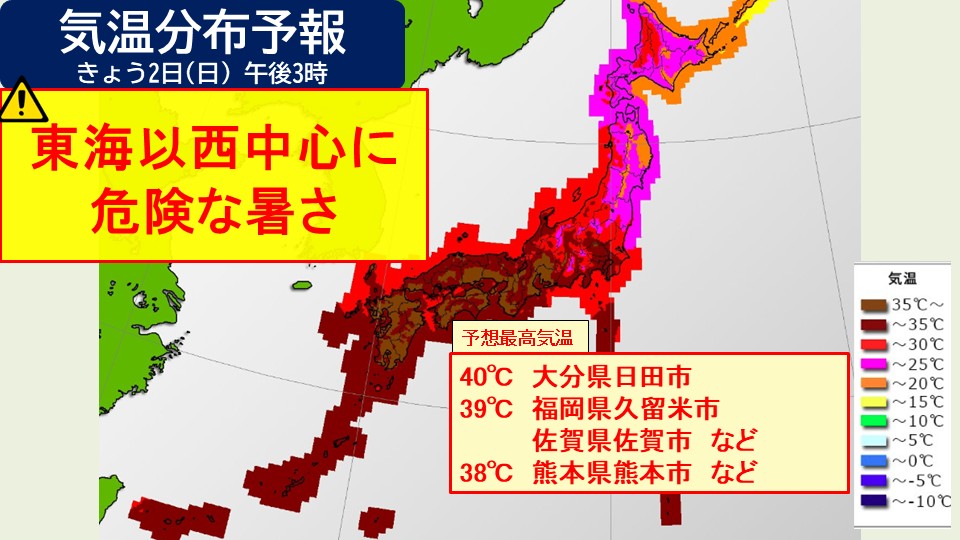
From the Tokai region to the west, the heat will continue to be severe today.
In Kumamoto, where there was a particularly strong earthquake, the predicted maximum temperature is 40 degrees Celsius, which could lead to dangerous heat. Please be extremely careful about heat stroke. Please do not push yourself too hard during recovery activities outdoors, and please continue to drink water frequently and take appropriate breaks. Kurume City (Fukuoka), Saga, and Hita City (Oita Prefecture) are also expected to experience extreme heat of 40 degrees Celsius, while many other areas in the Chugoku region and Kyushu are also expected to experience temperatures of 37 to 39 degrees Celsius, so please take all possible precautions against heatstroke.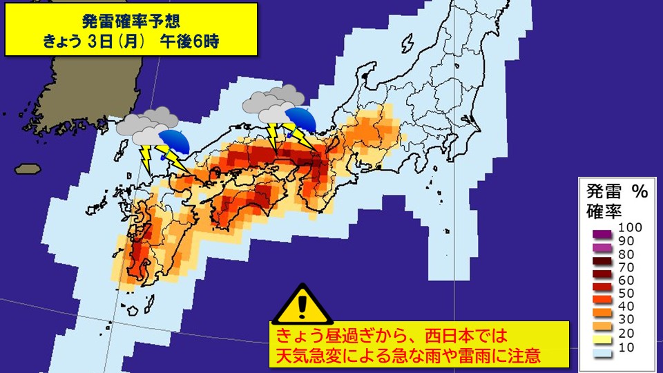
In the afternoon, atmospheric conditions will become unstable in western Japan due to the effects of daytime temperature rise. Thunderclouds tend to develop inland and along the mountains, so be careful of sudden changes in the weather. Please be careful of flooding of roads and rising river levels due to sudden and severe thunderstorms, and be aware of changes in sky conditions as severe gusts of wind such as lightning and tornadoes may occur.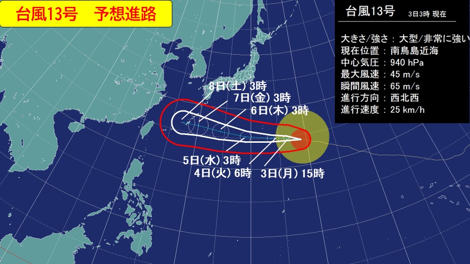
In the south of Japan, a large and very strong typhoon No. 13 is moving westward. The Ogasawara Islands will be subject to severe weather starting tonight, and people should be on high alert for strong winds and high waves from tomorrow 4th to around 5th. Also, depending on the degree of development of rain clouds, there is a risk of heavy rain reaching warning level, so please be careful of landslides and flooding of low-lying areas.
-
[Typhoon information] Very strong typhoon No. 13 (Dolphin) approaching Ogasawara Islands and Okinawa
2026/08/02 08:01

-
As of 6 a.m. today, the 2nd (Sunday), extremely strong Typhoon No. 13 (Dolphin) is moving west-northwest in the waters near Minamitorishima.
There is a high possibility that it will pass the Ogasawara Islands from the 4th (Tuesday) to the 5th (Wednesday) tomorrow, and head toward Okinawa and Amami in the latter half of the week. Please be aware of the upcoming path and be fully prepared for the storm.
Typhoon No. 13 (Dolphin) August 2nd (Sunday) 6:00am Current
Center location Near Minamitorishima
Size class //
Strength class Very strong
Movement West-northwest 25 km/h
Central pressure: 940 hPa
Maximum wind speed: 45 m/s (near the center)
Maximum instantaneous wind speed: 65 m/s
The typhoon has continued to move westward, and there is a growing fear that it will approach the Daito Island region of Okinawa with strong force on the 6th (Thursday). After that, there is a possibility that it will approach the Okinawa main island region and Amami region, so we need to be careful about its future course. Depending on the path, there is a risk of heavy rain and wind in the second half of the week, leading to severe storms.
Also, there is a possibility that the typhoon will change course to the north and approach Kyushu over the next week, so please pay close attention to future typhoon information.
-
Dangerous heat in Tokai to Kyushu; 40c expected in Hita; temperature expected to rise to 38c in Kumamoto; strict warning against heatstroke
2026/08/02 06:45
-
Today, the 2nd (Sunday), the center of the high pressure system will remain mostly stationary from the Nansei Islands to the East China Sea. Strong sunlight will hit areas where heat has accumulated due to the previous heat, mainly in the Tokai region and Kyushu region. The temperature will rise even further today, the 2nd (Sunday).
Today, the 2nd (Sunday), the summer Pacific high pressure system will be located in the East China Sea, covering a wide area of western Japan and the East Sea. Extremely warm air with temperatures of 21 degrees Celsius approximately 1,500 meters above Honshu is expected to spread from western to eastern Japan.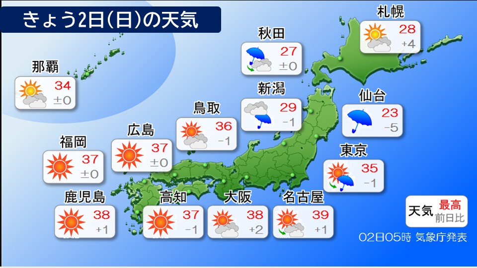
In Nagoya and Gifu, the predicted maximum temperature is expected to be 39 degrees Celsius, one step closer to becoming an extremely hot day.
Temperatures are high even in western Japan, with the highest temperature expected to be 40 degrees Celsius in Hita City, Oita Prefecture, which is expected to be an extremely hot day. Temperatures will also rise to 39 degrees Celsius in Okayama, Yamaguchi, Takamatsu, Tokushima, and Saga, making it extremely hot. Even in Kumamoto, which was hit by a big earthquake the other day, temperatures are expected to reach 38 degrees Celsius.
During the day, it is likely to be so hot that it is dangerous to go out, especially in areas west of the Tokai region. Please refrain from going out during the day and stay indoors where it is cool. If you have to go out, be sure to take frequent breaks and stay hydrated.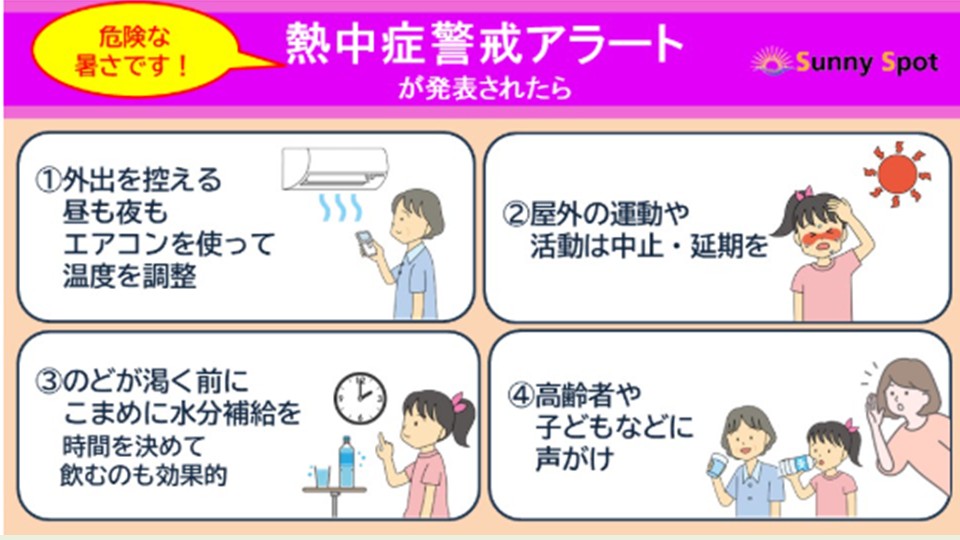
-
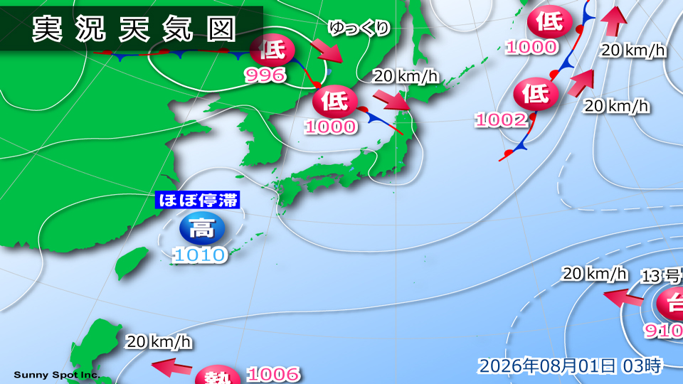
Rainy season front stagnates; Tohoku Sea of Japan side is on high alert for landslides
2026/08/01 07:04
-
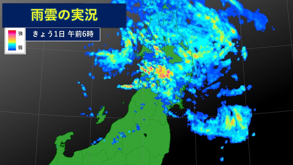
A low-pressure system is located in the Sea of Japan, and a front is extending from the Northeastern District of China to the Tohoku region. This low pressure system is expected to pass through the Tohoku region tomorrow, the 2nd (Sunday), and move towards the east of Japan.
Atmospheric conditions are unstable as warm, humid air is flowing toward fronts and low pressure systems.
By 3 o'clock, extremely heavy rain was being observed at Kaneyama in Yamagata Prefecture, at 59 mm/h, and at Sasunabe in Mamurogawa Town, at 55.0 mm/h, making it the highest rainfall in history for this location in Kanayama.
As of 6:50, there are areas in Akita, Iwate, and Yamagata prefectures where a Level 4 landslide warning has been issued.
Today, the 1st (Saturday), heavy rain is expected to occur in the Tohoku region, accompanied by thunder, and there will be heavy rain in some places.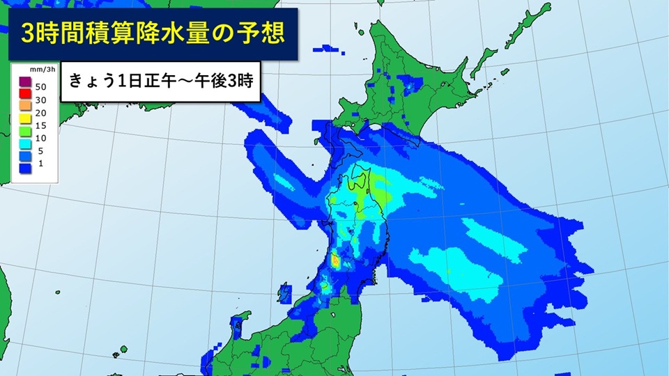
On the Sea of Japan side of Tohoku, please be on high alert for landslides caused by heavy rain until the evening of today, 1st (Saturday), and be careful of flooding of low-lying land, rising water levels and flooding of rivers. After that, please continue to be careful in the Tohoku region for flooding of low-lying areas and rising river waters until dawn on Sunday, the 2nd, and for landslides until late at night on Sunday, the 2nd. The ground has become loose in some places due to the rain that has fallen so far, so even a small amount of rain can increase the risk of landslides.
Also, be careful of lightning strikes and gusts of wind in the Tohoku region.
#Expected amount of rain (in places where there is a lot)
+Precipitation expected for 1 hour today (Saturday)
Tohoku Sea of Japan side 40mm
Tohoku Pacific side 30mm
+An hourly precipitation expected for tomorrow 2nd (Sunday) Tohoku Japan Sea side 30mm
Tohoku Pacific side 20 mm
+Precipitation amount expected for 24 hours by 6:00 tomorrow 2nd (Sunday)
Tohoku Sea of Japan side 120 mm
Tohoku Pacific side 100 24-hour precipitation expected by 6:00 a.m. on the 3rd (Monday) the following day: Tohoku Sea of Japan side 60 mm
Tohoku Pacific side 30 mm
-
Weather for today (Saturday): Heavy rain in Tohoku; sunny and extremely hot in Kanto and westward
2026/08/01 06:34
-
The rainy season front is expected to remain in northern Japan today, the 1st (Saturday). It will be a rainy day in northern Japan. From the Kanto region to the west, a high pressure system covers the area and the weather continues to be sunny and extremely hot, so people need to be careful of heatstroke.
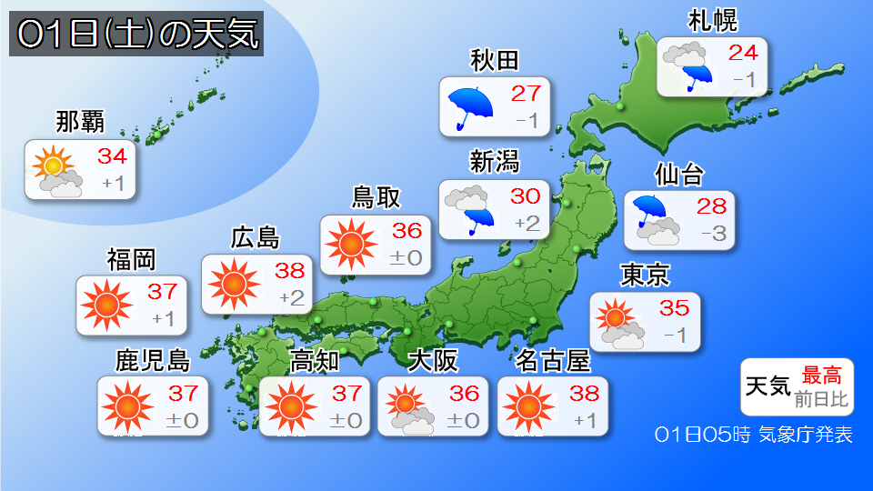
Clouds tend to spread in northern Japan, and intermittent rain will continue mainly in Tohoku. In the northern Tohoku region, the rain is expected to increase locally, causing heavy rain and thunderstorms in some places. The ground has become loose in some places due to the rain that has fallen so far, so even a small amount of rain can increase the risk of landslides. Please be extremely careful about landslides.
It is expected to be sunny and bright with strong sunlight from the Kanto region to western Japan. In many places, the heat will be dangerously high, exceeding body temperature, and in some places it will be as hot as an extremely hot day. Please continue to take all possible precautions against heat stroke, such as staying hydrated and taking salt supplements.
In addition, rain clouds are expected to develop locally in the afternoon, mainly along the mountains of the Kanto region. Please pay attention to changes in the sky.
-
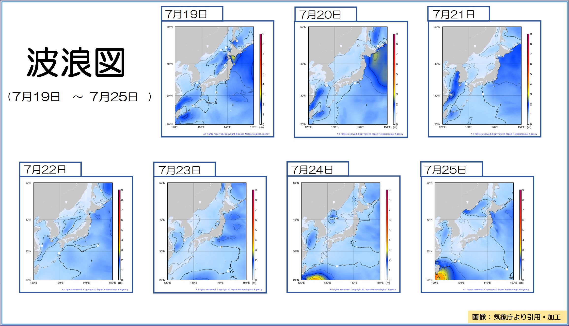
[Ocean Summary] Seas near Japan remain relatively calm (July 19-25, 2026)
2026/07/31 11:41
-
Although there were times when the waves were high due to low pressure and fronts, the seas around Japan remained relatively calm.
Below is a summary of the ocean (July 19-25, 2026)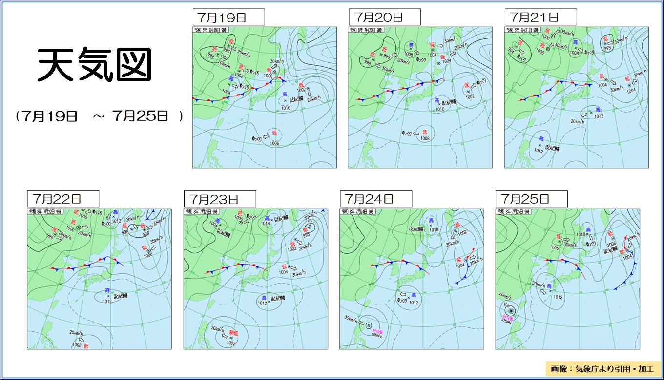
#Pressure distribution and waves
From the 19th to the 22nd, the front moved from central China to the Sea of Japan and stalled near northern Japan. From the 19th to the 20th, a low-pressure system separated from the front moved northeast across the southern Sea of Okhotsk from west of Hokkaido, resulting in high waves of around 3.0 m on the Pacific side of Hokkaido. From the 23rd to the 25th, the front gradually moved southward to the Kanto region. From the 24th to the 25th, the tropical cyclone turned into Typhoon No. 12 and moved westward in the South China Sea, causing waves to reach a height of 3.0 meters in the Sakishima Islands on the 25th. During this period, the Pacific high pressure system was mostly stationary south of the front, so the waves in the Japanese waters and the Pacific side of western Japan were around 1.0m in height.
#Sea surface temperature
Sea surface temperatures near Japan are expanding in areas where they are higher than normal. Continuing from the previous week, temperatures were significantly higher than normal mainly in the northern part of the country, with temperatures up to 5 C higher than normal off the southeastern coast of Hokkaido. Sea areas in Japan continued to be warmer than normal, with temperatures reaching a maximum of 4 C above normal. Sea surface temperatures in the East China Sea and the waters near the Nansei Islands were slightly lower than normal in the first half of the week, but from the second half of the week they ranged from normal to slightly higher than normal. Sea areas off the southeastern coast of the Kanto region continue to be slightly lower than normal. In the waters near the Kuril Islands, the area of higher-than-normal waters has shrunk.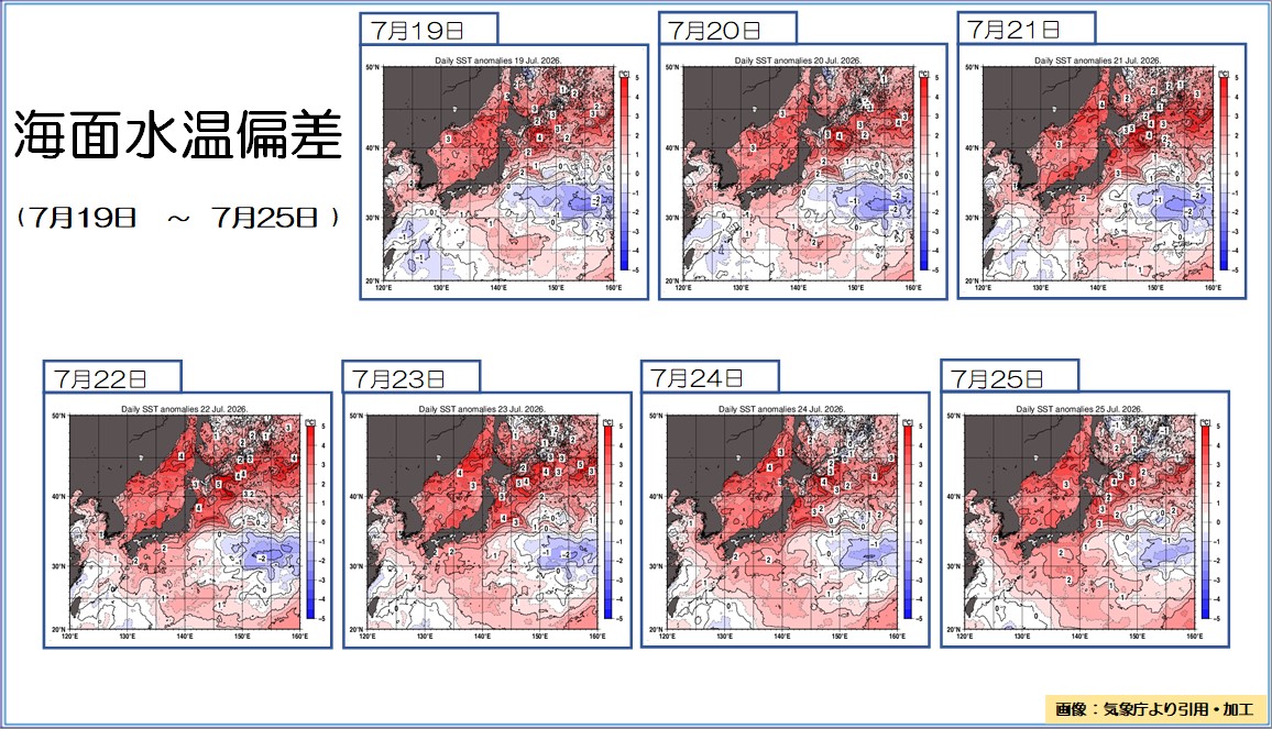
-
Weather for today, the 31st (Friday): Rain in northern Japan and Hokuriku; intense heat continues from Kanto to western Japan
2026/07/31 07:05

-
Today, the 31st (Friday), it will rain from Hokkaido to Tohoku and Hokuriku due to the effects of low pressure and a trough of pressure. There are areas where the ground has become loose due to the rain that has fallen so far, so caution and vigilance against landslides is required.
West of the Kanto region, there will be many sunny and extremely hot days. Please be careful of heat stroke.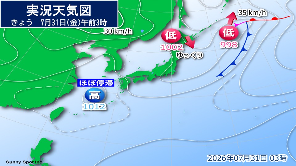
A low pressure system is located east of Japan and moving northeast. Another low pressure system is located west of Hokkaido and is moving slowly southward. On the other hand, there is an anticyclone in the East China Sea that gently covers western and eastern Japan.
Currently, it is raining in some places in Hokkaido, Niigata Prefecture, Fukushima Prefecture, and northern Kanto.
There are places in Fukushima Prefecture where level 4 landslide warnings have been issued. Please be on high alert for landslides until noon.
Atmospheric conditions continue to be unstable in northern Japan and Hokuriku, with warm, humid air flowing toward low-pressure systems and troughs.
Please be careful of landslides, flooding of low-lying areas, and rising river waters. Also, be careful of lightning, tornadoes, strong wind gusts, and hail.
Sunlight will reach from Kanto-Koshin to western Japan and Okinawa.
However, please be careful of sudden thunderstorms in the afternoon in Kanto-Koshin. Please carry a folding umbrella or an umbrella for both rain and shine, and pay attention to changes in the sky.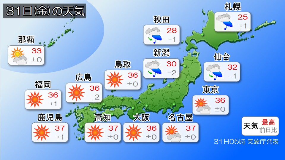
It is expected to be an extremely hot day with maximum temperatures of over 35c from Kanto-Koshin to western Japan. Please continue to be careful of heat stroke.
Even in Kumamoto Prefecture, which suffered damage from the recent earthquake, temperatures are expected to reach 36 degrees Celsius, which is similar to body temperature. Those involved in recovery work should take frequent breaks and remember to replenish water and an appropriate amount of salt.