-
Weather for tomorrow 6th: Honshu is a perfect day for tourists, a front is gradually approaching on the Pacific side
2026/05/05 12:35
-
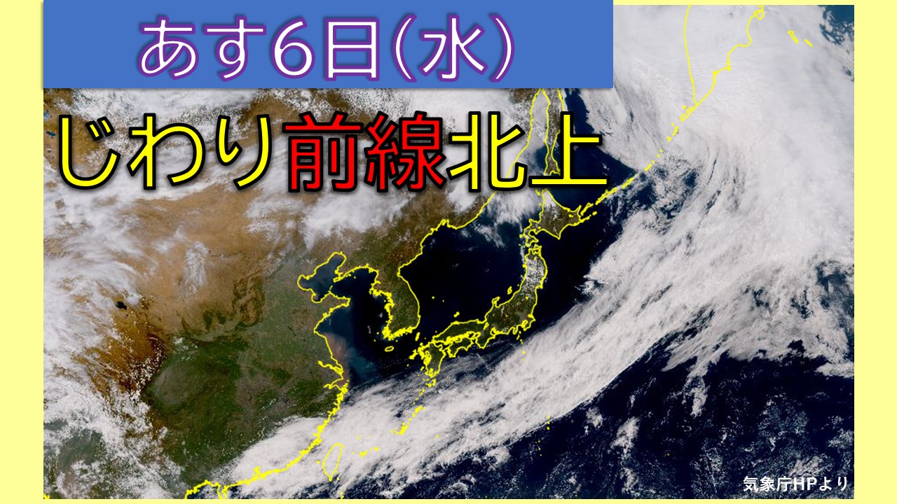
Today, the 5th, blue skies are spreading around Honshu, but tomorrow, the 6th, the area will continue to be covered in high pressure, and it is expected to be sunny over a wide area. It looks like it's going to be a day where you can feel the warmth of the sunlight. For the second half of Golden Week, we can expect mild weather that will make it easier to plan outings and excursions.
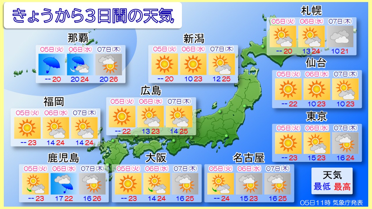
There are many sunny weather marks in the second half of the week, but the weather in the Pacific coast area is actually likely to be unpredictable.
Looking at the Himawari meteorological satellite, a rainy season front extends east to west over the southern ocean. There are signs that this front will slowly move northward from tomorrow onwards. It will be a little while before the front hits Honshu, but as moist air tends to flow in mainly from the Pacific side, clouds may spread more easily in some areas.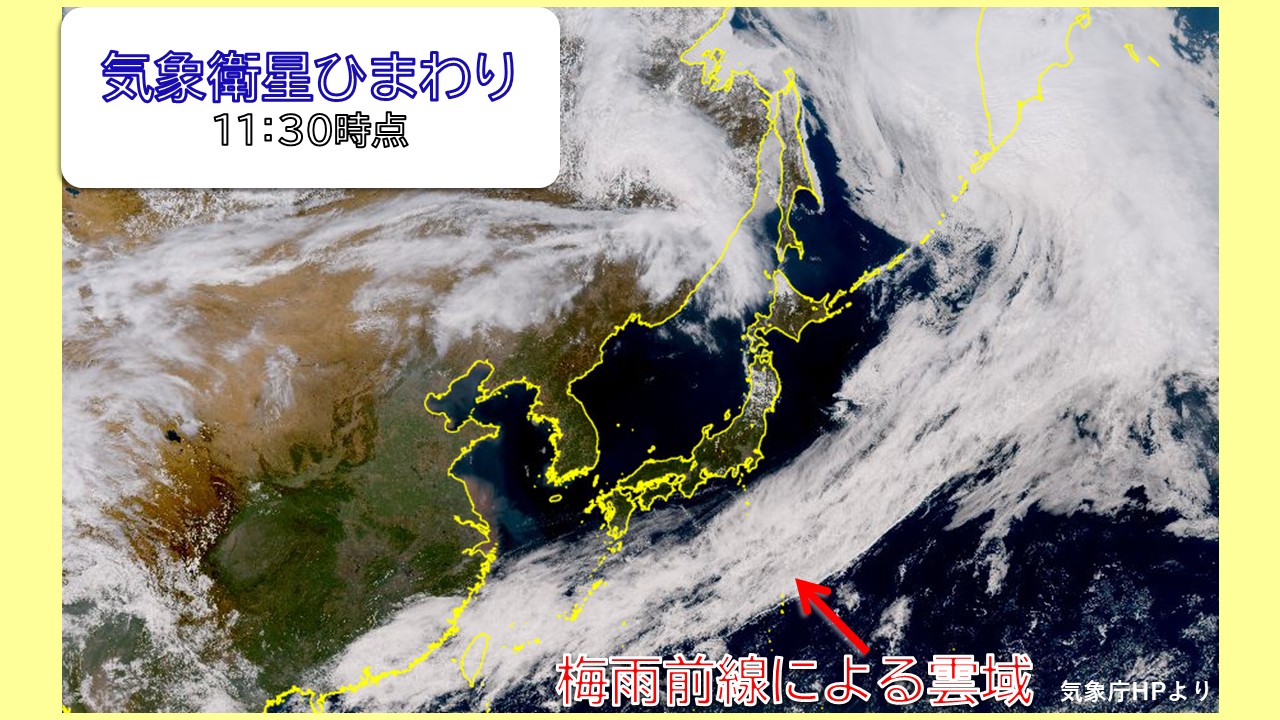
The area of particular attention is the Pacific coast. In coastal areas from the Kanto region to the Tokai region, Kinki, Shikoku, and Kyushu, clouds will become thicker in the afternoon due to the influence of moist air flowing toward the front, and there is a possibility of rain in some places. Although the rain is localized and it is unlikely to be a full-fledged rain that continues for a long time, it is safe to have a folding umbrella when going out.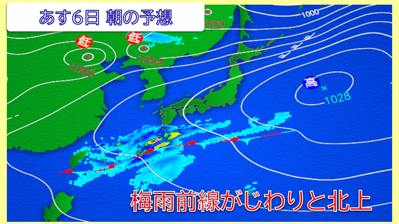
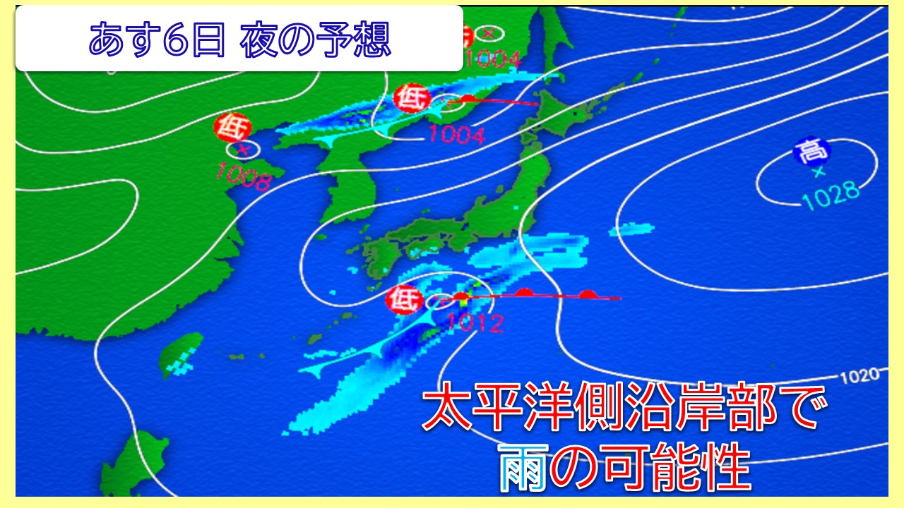
Southern Kyushu is close to the front, so the period of rain is expected to be a little longer. Particularly in parts of Kagoshima Prefecture, there is a possibility that the rain may become a little heavier as the front approaches. At this time of year, just before the start of the rainy season, even a slight change in the position of the front can make a big difference in the weather, so please check the latest weather information using a rain cloud radar.
Tomorrow, the 6th, looks like it will be a day with big differences in weather depending on the region. If you are planning to go on a vacation or go out, it is a good idea to check the pinpoint forecast for your destination and prepare for changes in the weather.
-
Be careful of strong winds mainly in the Tohoku region from today 4th to tomorrow 5th.
2026/05/04 15:34
-
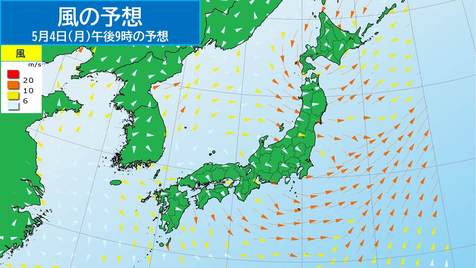
Today, the 4th (Monday/Greenery Day), winds are increasing in various places due to the influence of low pressure and fronts moving near northern Japan. Even if the weather improves until tomorrow the 5th (Tuesday/Children's Day), please be careful of strong winds and storms.
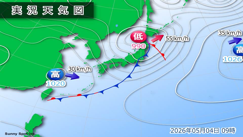
Today, the 4th (Monday), a low pressure system with a front is near Hokkaido and is moving northeast. This low-pressure system is expected to develop and move through the Hokkaido region, reaching the waters near the Chishima Islands.
This low pressure system is causing strong winds in many places.
Today, the 4th (Monday), the maximum instantaneous wind speed was 28.5 m/s at 6:04 am in Chiba, Chuo Ward, Chiba City, 27.5 m/s at 0:05 am at Cape Muroto, Muroto City, Kochi Prefecture, and 26.9 m/s at 5:13 am in Gotemba, Gotemba City, Shizuoka Prefecture.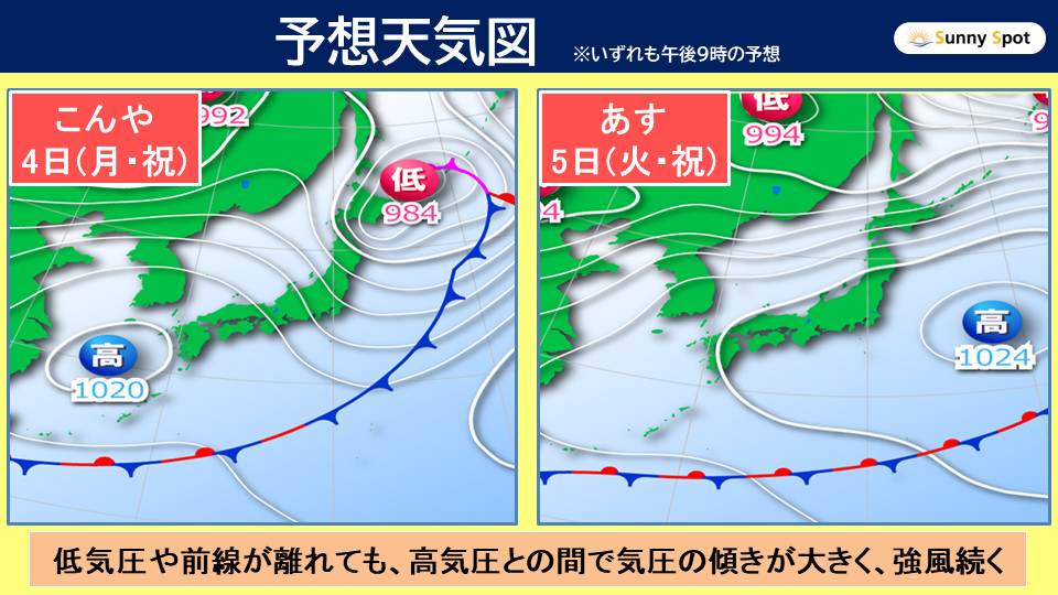
After this, even if the low pressure system or front passes, there will be a large pressure gradient between it and the high pressure system moving east from near the East China Sea, and strong winds are expected to continue in many places.
Even if the weather improves, please be careful of the increasing wind.
As of 3:00 p.m. today, Monday, April 4, a storm warning has been issued for Sanyakamikita, Aomori Prefecture, and eastern Miyagi Prefecture.
On the Pacific side of Tohoku, extremely strong winds are expected to blow from the west due to the influence of a developing low pressure system. Please be on guard for strong winds from the west from the evening until late at night today, the 4th (Monday).
If the low-pressure system develops more than expected or if the gradient of the atmospheric pressure becomes large, there is a possibility of warning-level winds from the west even on the Sea of Japan side of the northeastern Japan.
[Wind forecast]
Maximum wind speed (maximum instantaneous wind speed) expected on the 4th
Tohoku Sea of Japan side Sea 18 meters (30 meters)
Tohoku Sea of Japan side Land 15 meters (30 meters)
Tohoku Pacific side Sea 20 meters (30 meters)
Tohoku Pacific side Sea 18 meters (30 meters)
Tohoku Pacific side Sea 18 meters (30 meters)
-
Be careful of strong winds and high waves even after the low pressure passes
2026/05/04 13:05
-
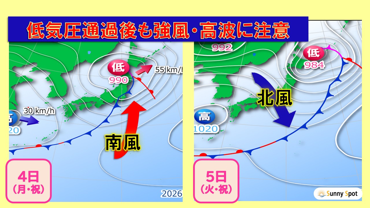
A low pressure system is moving northeast near the Oshima Peninsula, and this is causing rain in Hokkaido and the Sea of Japan side of eastern Japan. The weather is improving in other areas, but although the weather is becoming more sunny, sea and wind conditions remain unstable, so caution is still required.
A storm warning has been issued for parts of the Pacific side of northern Japan.
The low pressure system will be sandwiched between the high pressure system to the east of Japan and the high pressure system extending from the continent, and the gradient of the atmospheric pressure is expected to increase.
The southerly wind has already strengthened during the day on the 4th (Monday), but it is expected to change to the northerly wind from the evening. Strong winds are expected to continue, and caution should be taken to avoid rising waves and the impact on transportation.
Currently, a wave warning has been issued for eastern Kanagawa Prefecture. As strong winds continue in other areas, there is a risk of getting caught in unexpected high waves if you get too close to the shore. Please be careful near the coast.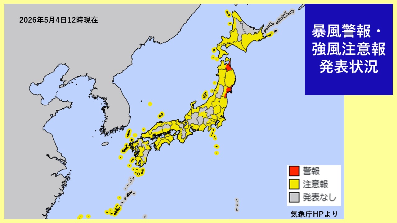
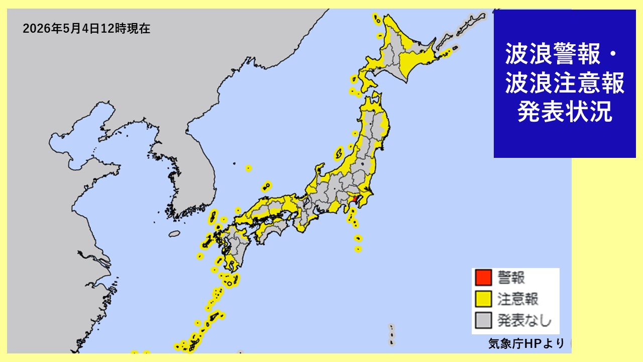
If you are planning to go outdoors during the holidays, please check the status of advisories and warnings frequently and avoid approaching dangerous areas. Please continue to check the latest weather information.
-
Today, the 4th (Monday), winds are increasing across the country, and there is a risk of warning-level storms in the Tohoku coast.In Hokkaido, watch out for unseasonable snow.
2026/05/04 08:36
-
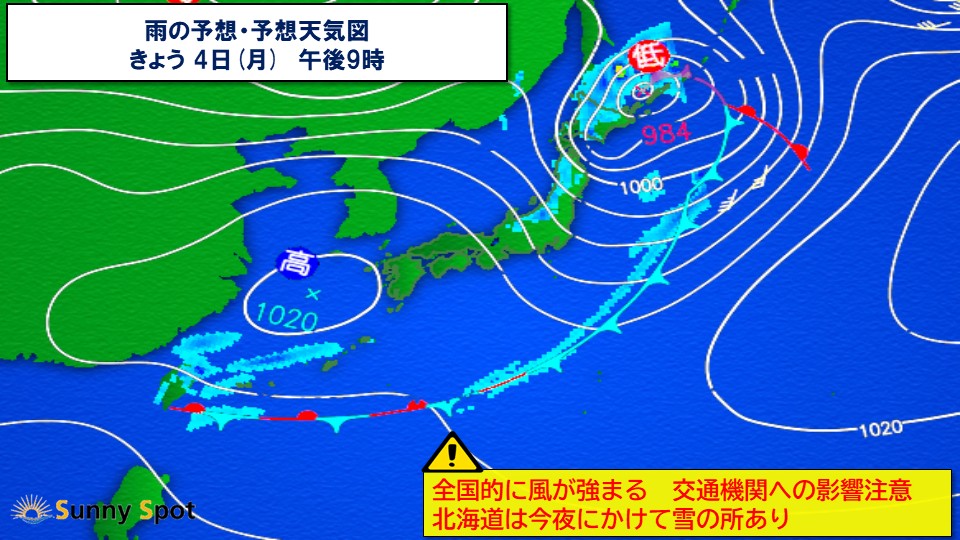
Today, the 4th (Monday), a low pressure system will continue to develop as it moves through the Sea of Japan. Winds are increasing across the country, and there is a risk that it will become a warning-level storm in the Tohoku Pacific Ocean. Also, please be careful of wet snow in Hokkaido from the evening until tonight.
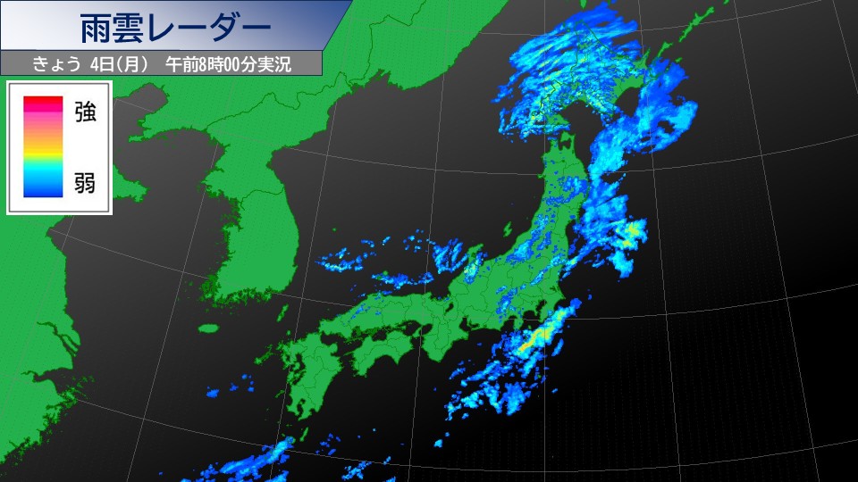
Looking at the rain cloud radar at 8 a.m., developed rain clouds are centered over northern Japan. There are almost no rain clouds in western Japan, and the weather is improving. On the Pacific side of eastern Japan, active rain clouds can be seen near the Izu Islands, but the rain has stopped in many places.
However, from northern Japan to western Japan on the Sea of Japan side, atmospheric conditions become unstable due to the influence of cold air. It will rain on and off from Hokuriku to Kyushu.
Due to the developing low pressure system, winds will become stronger across the country, and some coastal areas will experience extremely strong winds. Even in areas where the rain has stopped, you need to be careful of strong winds and be aware of the impact on transportation. In the Tohoku region, the maximum instantaneous wind speed is expected to reach 30 meters, and there is a risk that it will become a warning-level storm. Be wary of strong winds and high waves, and pay close attention to the impact on transportation.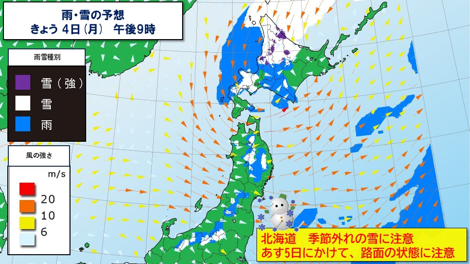
In Hokkaido, there will be places where the rain will turn to snow from evening to night due to the influence of cold air above. There is a risk of wet snow even in flat areas, with heavy snow accumulation into the morning hours tomorrow. Please be careful of deteriorating road conditions, and be careful of wet snow accumulating.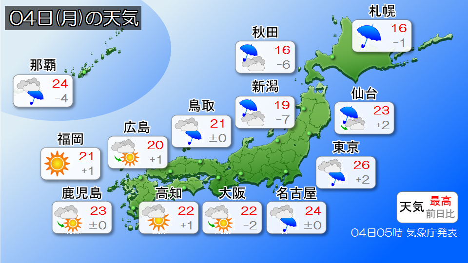
-
"Rainy season" announced in the Amami region - entering the rainy season ahead of the rest of the country
2026/05/03 20:09
-
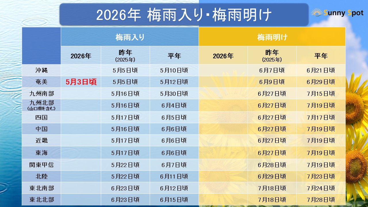
Today, the 3rd (Sunday), the Kagoshima Local Meteorological Observatory announced that the rainy season appears to have begun in the Amami region.
The start of the rainy season in the Amami region will be announced nine days earlier than normal and two days earlier than last year in 2025. This will be the first rainy season in Japan in 2026, and it will be the first time since 2019 that the rainy season will start before Okinawa.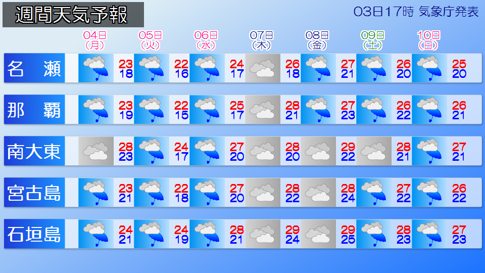
The Amami region will continue to have many cloudy and rainy days, and the weather will continue to be unrefreshing. Depending on the weather conditions and how rain clouds develop, there is a possibility of heavy rain shortly after the start of the rainy season, so please be sure to check the latest weather information.
Okinawa will also have a lot of cloudy and rainy weather from now on. The rainy season may be coming soon.
*The rainy season is a seasonal phenomenon, and there is an average "transition" period of about 5 days between the start and end of the rainy season. Please note that this announcement of the start of the rainy season is preliminary information and will be reconsidered in the fall, and the timing may be revised.
-
Be careful of heavy rain, thunder, and gusty winds in eastern and western Japan and the Nansei Islands until tomorrow the 4th.
2026/05/03 18:31

-
The Japan Meteorological Agency has released the third general weather information regarding heavy rain, lightning, and gusts.
A low pressure system accompanied by a front is moving east-northeast across the western Sea of Japan.
This low-pressure system is expected to pass through the Sea of Japan and the Hokkaido region and move toward the waters near the Chishima Islands, and the front is expected to pass over Honshu and the Nansei Islands into the night of tomorrow, the 4th (Monday).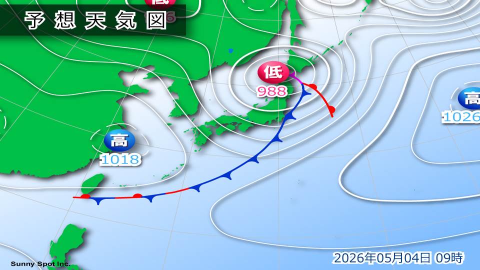
Atmospheric conditions are expected to be extremely unstable from eastern Japan to western Japan and the Nansei Islands from tomorrow, the 4th (Monday), due to warm, humid air flowing toward the low pressure system and front, as well as cold air in the upper atmosphere.
Be careful of landslides, flooding of low-lying areas, and rising river levels, and be careful of lightning, tornadoes, and other strong gusts of wind and hail.
If there are signs of a developing cumulonimbus cloud approaching, please take precautions such as moving inside a building. There is also a risk of hail, so please be careful when managing crops and agricultural facilities.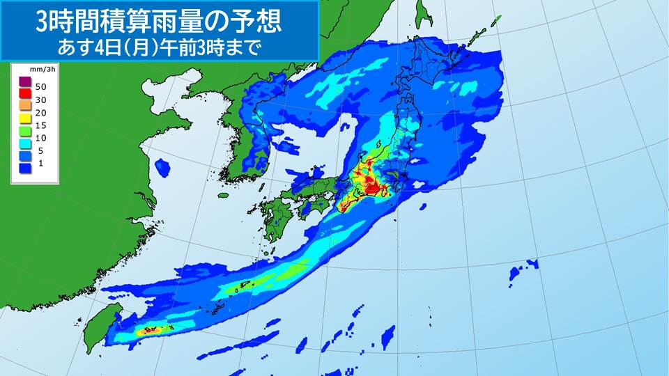
[Rain Forecast]
The predicted 24-hour precipitation from 18:00 on the 3rd (Sunday) to 18:00 on the 4th (Monday) will be high in the Hokuriku region
100mm
Kinki region 150mm
Okinawa region 80mm
[Disaster prevention matters]
From eastern Japan to western Japan and the Nansei Islands, please be careful of the following points from Monday the 4th.
+Landslides, flooding of low-lying land, rising river levels
+Severe gusts such as lightning strikes and tornadoes
+Damage to crops and agricultural facilities due to hailstorms
-
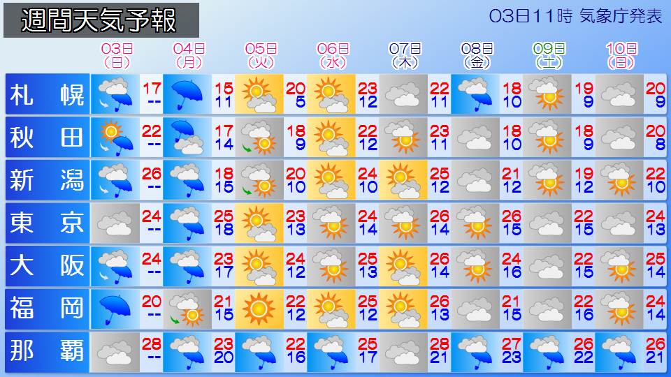
Weather for the week Today, the 3rd and 4th, a low pressure system will pass and it will rain widely. The latter half of Golden Week, the 5th and 6th, will be good days for going out.
2026/05/03 14:42
-
From today, the 3rd (Sunday, Constitution Day) to tomorrow, the 4th (Monday, Greenery Day), the weather is expected to deteriorate widely and rain is expected due to the effects of low pressure and fronts moving east-northeast across the Sea of Japan.
In the second half of Golden Week, from the 5th (Tuesday, Children's Day) to the 6th (Wednesday, substitute holiday), the weather will improve in many places, making it a good day to go out. However, Okinawa/Amami will continue to experience rainy weather.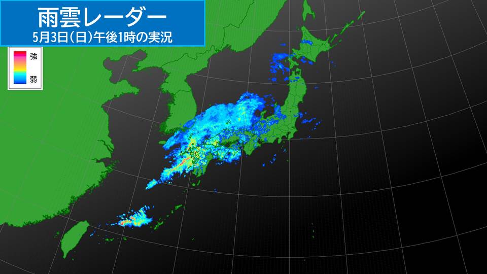
Currently, a low pressure system accompanied by a front is moving east-northeast near the Tsushima Strait, causing rain to fall over a wide area of western Japan and the Hokuriku region.
The low pressure system is then expected to move east-northeast across the Sea of Japan until tomorrow, the 4th (Monday), and the front is expected to pass from eastern Japan to the Nansei Islands. The area of rain will spread to eastern and northern Japan.
Atmospheric conditions will be extremely unstable in some places as warm, humid air flows towards low pressure systems and fronts. From eastern to western Japan, heavy rain with localized lightning is expected to occur in some places from tomorrow, the 4th (Monday). Please be careful of landslides, flooding of low-lying areas, and rising river levels, and be careful of lightning, tornadoes, strong wind gusts, and hail.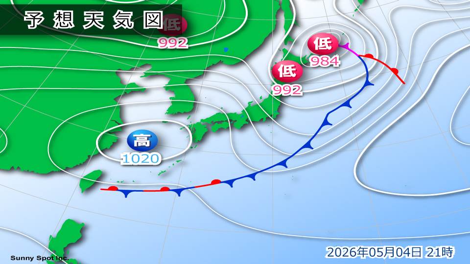
Tomorrow, the 4th (Monday), the weather will gradually improve as high pressure will emerge from the west. However, there will be places on the Japan Sea side, such as northern Japan and Hokuriku, where it will continue to rain. In Hokkaido, cold air is expected to enter the sky from the afternoon of the 4th (Monday) to the 5th (Tuesday), so there will be places where wet snow will fall, mainly on the Sea of Okhotsk side.
In addition, strong winds are expected to continue, especially in northern Japan, which is close to a low pressure system.
Please check the latest information as there may be an impact on transportation.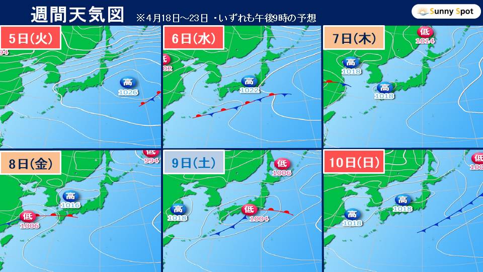
On the 5th (Tuesday) and 6th (Wednesday), the latter half of Golden Week, the area around Japan will be covered in high pressure, and many places will be sunny. It looks like it's going to be a good day to go out. However, Okinawa/Amami will continue to experience rainy weather due to the influence of moist air around the edge of the high pressure system and a front to the south of Japan.
After Golden Week, a low-pressure system with a front from the west will move eastward from the 8th (Friday) to the 9th (Saturday), increasing clouds on the Pacific side, and it is likely to rain in some places.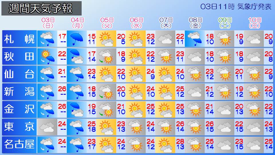
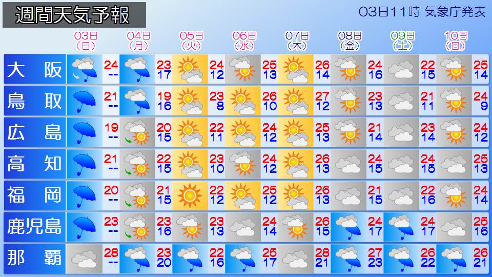
Temperatures are expected to be higher than normal in some places on sunny days.
In Hokkaido, the weather is expected to be sunny and warm from the 5th (Tuesday) to the 7th (Thursday), and the weather is expected to be as warm as June to July.
In Tokyo, summer weather is expected to reach 26c from the 7th (Thursday) to the 8th (Friday) after Golden Week.
If you are planning to do outdoor leisure activities during the holidays, please take precautions against heat stroke, such as taking frequent breaks and consciously drinking water. It is also a good idea to bring a hat and a parasol to protect yourself from UV rays.
-
A low pressure system develops, warning of heavy rain disaster from western to eastern Japan from tomorrow 4th (Sunday)
2026/05/03 09:04
-
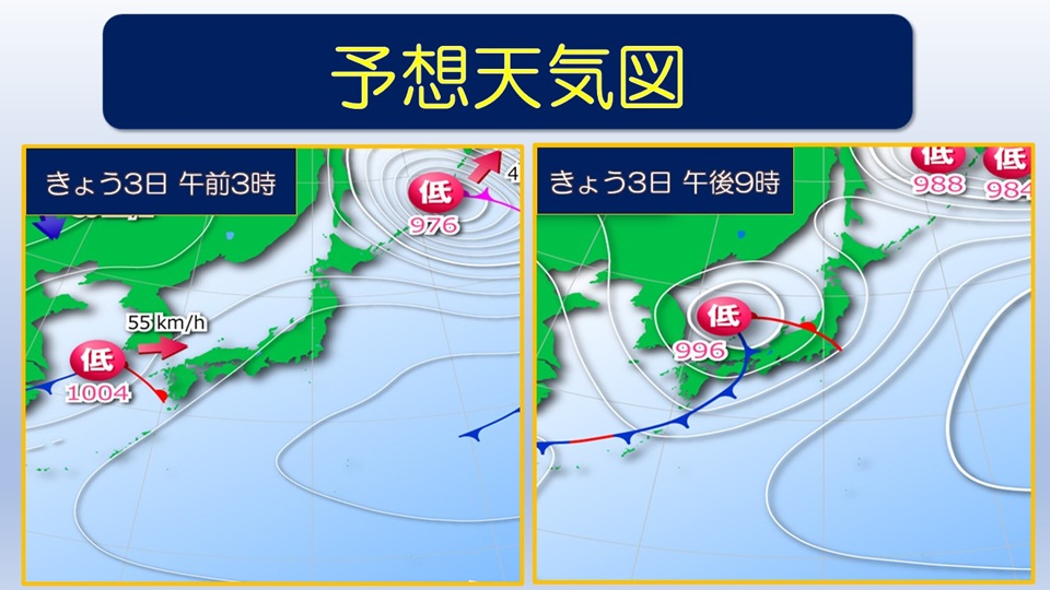
A low pressure system accompanied by a front is moving east-northeast across the Yellow Sea. This low pressure system will move east-northeast across the Sea of Japan until tomorrow, the 4th (Monday), and the front will pass from eastern Japan to the Nansei Islands. Atmospheric conditions are expected to become extremely unstable in some places as warm, humid air flows toward low pressure systems and fronts.
For this reason, rain clouds are likely to develop from western Japan to eastern Japan, and there is a risk of heavy rain accompanied by localized thunderstorms. Additionally, there is a risk of extremely heavy rain of more than 50 mm per hour, mainly on the Pacific side of western Japan, today, the 3rd.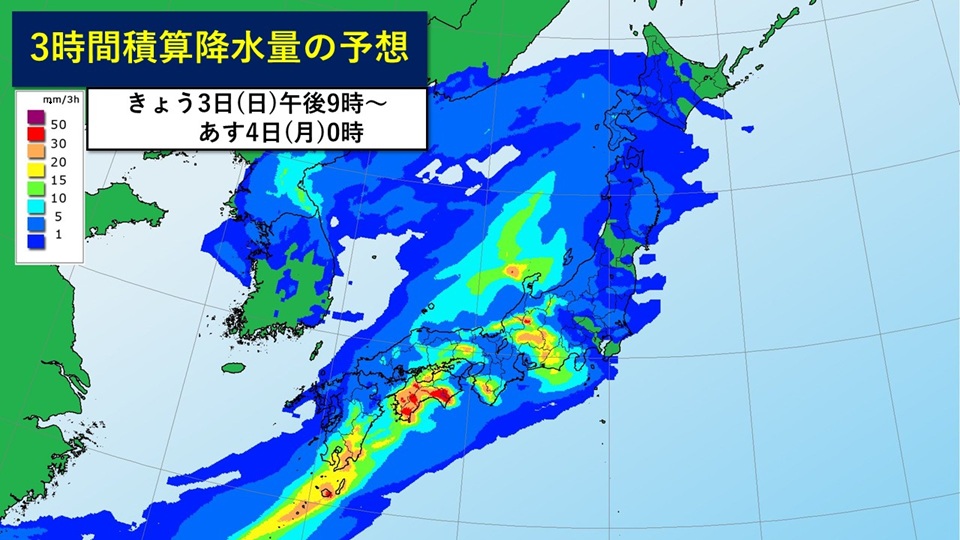
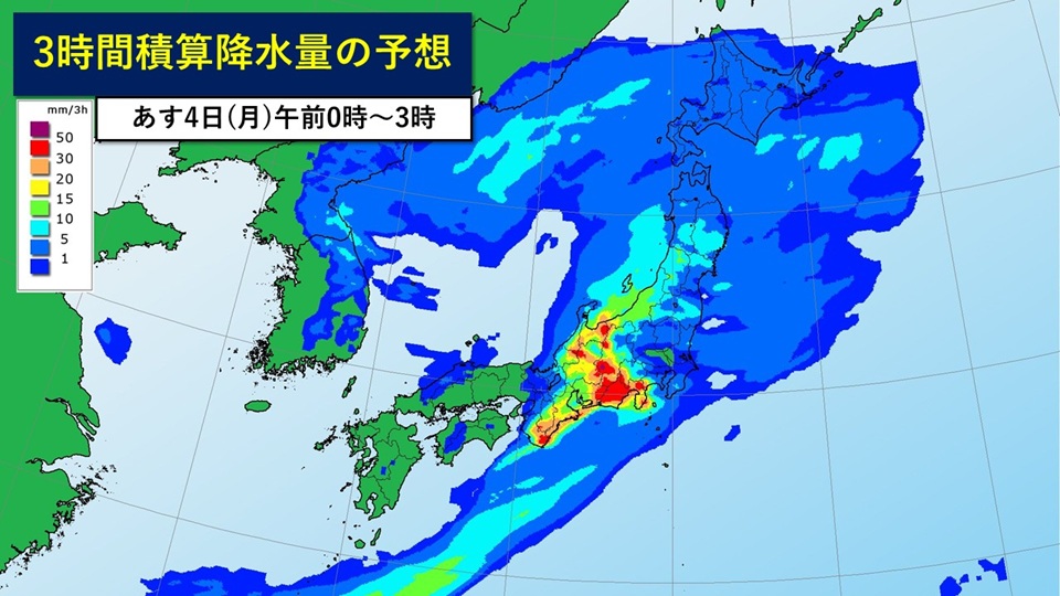
#Expected amount of rain (in areas where there is a lot)
+24-hour precipitation expected by dawn on the 4th (Monday) tomorrow
Hokuriku region 100 mm
Kinki region 15 0mm
80mm
#Disaster Prevention Matters
From eastern Japan to western Japan, caution and vigilance are required for landslides, flooding of low-lying land, and rising river waters from tomorrow 4th (Monday). Also, be careful of strong wind gusts such as lightning and tornadoes.
If there are signs of a developing cumulonimbus cloud approaching, please take steps to ensure your own safety by moving inside a building. There is also a risk of hail, so care must be taken when managing crops and agricultural facilities.
-
Today's weather on the 3rd (Sunday) Rain clouds are expanding from the west. Be careful of heavy rain from western Japan to eastern Japan.
2026/05/03 06:21
-
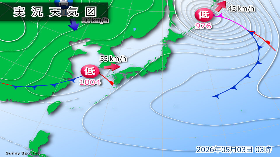
Today, the 3rd (Sunday), which is Constitution Day, a low pressure system accompanied by a front will move toward the Sea of Japan. The weather is expected to go downhill from the west near Japan, with rain expected to fall in the Kanto region and other areas at night. In northern Japan, the rain is more likely to fall later in the day, so it's likely to be a day when umbrellas will be useful over a wide area.
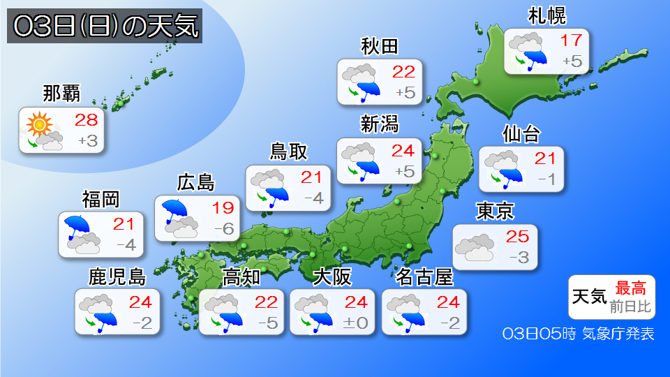
It will rain in Kyushu from the morning due to the effects of low pressure and fronts. Rain is expected to start in Chugoku, Shikoku, and Kinki around noon.
After the evening, the area of rain will spread to eastern Japan, and it is expected to rain in the Tokai and Hokuriku regions from the evening, and in the Kanto region at night. Even if it's not raining when you go out, please prepare rain gear in time for your return.
Also, atmospheric conditions will be unstable in the afternoon as moist air flows towards the low pressure system. Rain clouds will develop mainly on the Pacific side, and there is a risk of extremely heavy rain of over 50mm per hour. Please be careful of landslides and flooding of low-lying areas.
In northern Japan, clouds tend to spread around the Sea of Japan, and the weather is not clear. After the evening, the area of rain will expand from the Sea of Japan side, and there will be periods of sunlight in the morning, and there will be places on the Pacific side where it will start to rain at night. If you are returning home late, it is a good idea to have a folding umbrella.
The temperature will be lower than the previous day in many places, mainly from western Japan to eastern Japan, but it is likely that the temperature will be typical for this time of year in many places. Even in northern Japan, it will be as warm as normal. Please be careful about the temperature difference throughout the day.
-
[General weather information] May 3rd to 4th: Be careful of heavy rain, thunder, and gusts of wind
2026/05/02 17:22
-
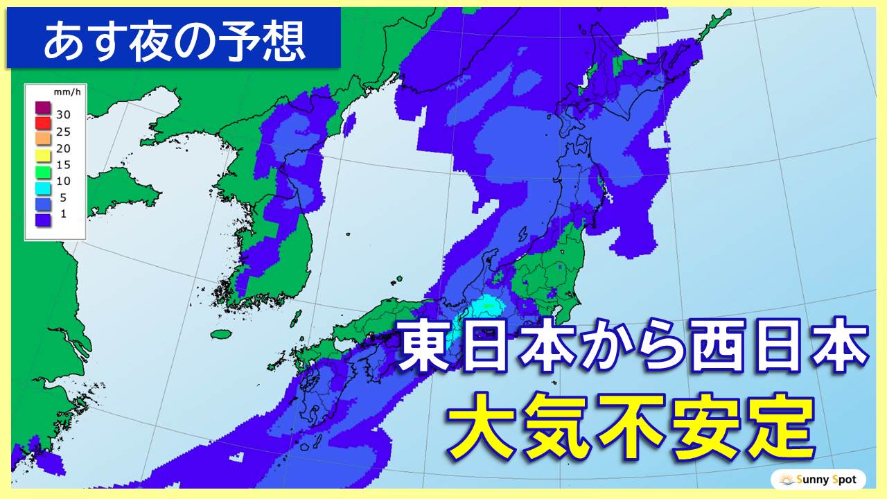
The Japan Meteorological Agency has released its first general weather information regarding heavy rain, lightning, and gusts.
A low-pressure system with a front near Central China is expected to move east-northeast across the Sea of Japan from the 3rd to the 4th, and the front is expected to pass from eastern Japan to the Nansei Islands.
Atmospheric conditions will be extremely unstable in some places as warm, humid air flows towards low pressure systems and fronts.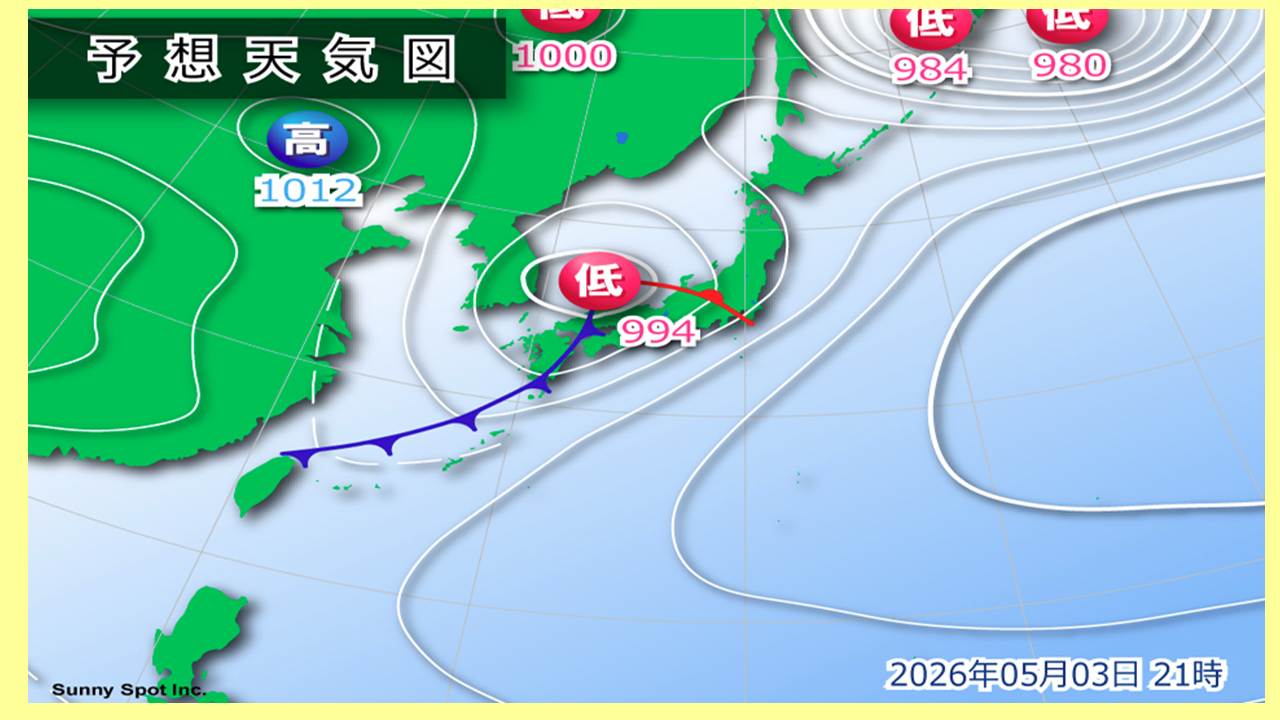
From the 3rd to the 4th, from eastern to western Japan, please be careful of landslides, flooding in low-lying areas, and rising river waters.
Also, be careful of lightning, tornadoes, strong gusts of wind, and hail.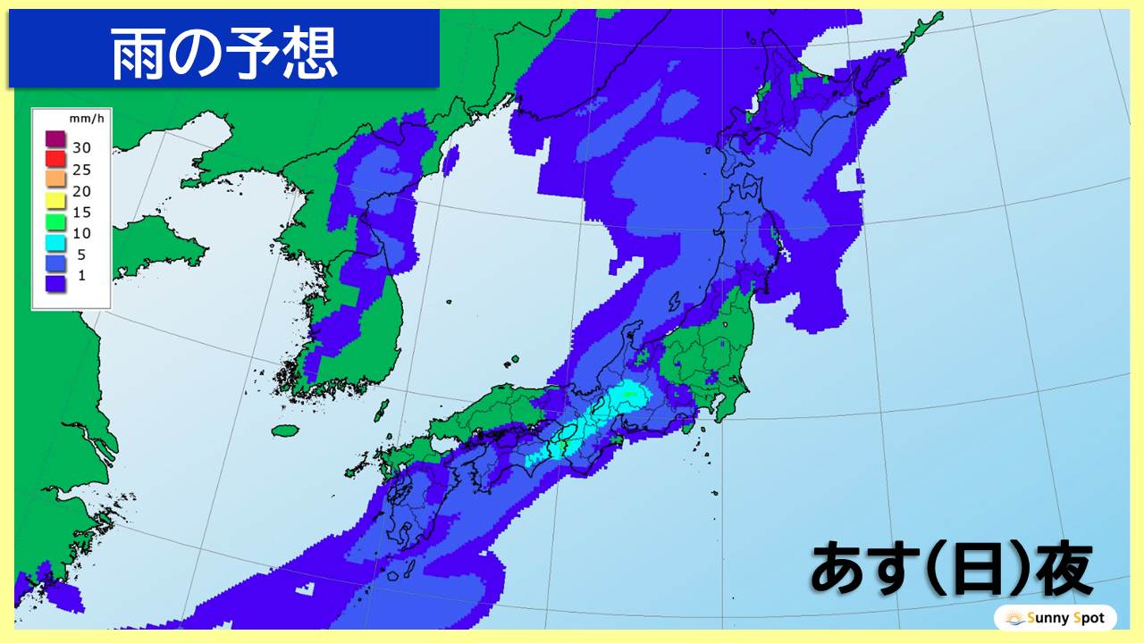
# Rain forecast
24-hour precipitation from 18:00 on the 3rd to 18:00 on the 4th (in areas with the most)
Hokuriku region: 100 mm
Kinki region: 150 mm
Okinawa region: 80 mm
# Disaster prevention precautions
From eastern Japan to western Japan, please be careful of the following points from the 3rd to the 4th.
+Landslides, flooding of low-lying areas, rising river levels
+Severe gusts caused by lightning strikes, tornadoes, etc.
+Damage to crops and agricultural facilities due to hailstorms
+If there are signs that a developed cumulonimbus cloud is approaching (suddenly darkening of the sky, hearing thunder, sudden cold wind blowing, etc.), prioritize safety by moving inside a building.


