-
Weather for tomorrow 13th (Wednesday): Widespread atmospheric instability; be careful of sudden thunderstorms
2026/05/12 18:07
-
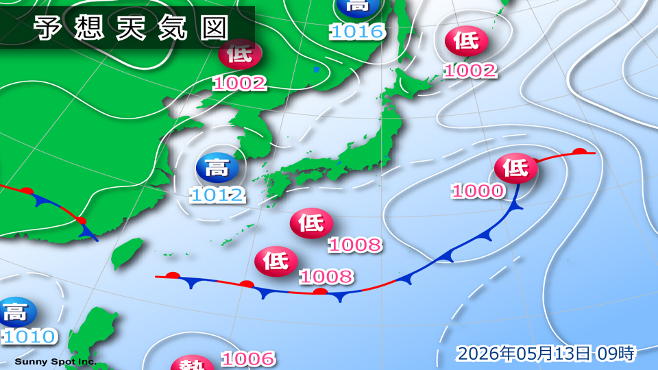
Tomorrow, the 13th (Wednesday), is likely to be a day where we will need to be careful about sudden changes in the weather, especially in inland areas and along the mountains.
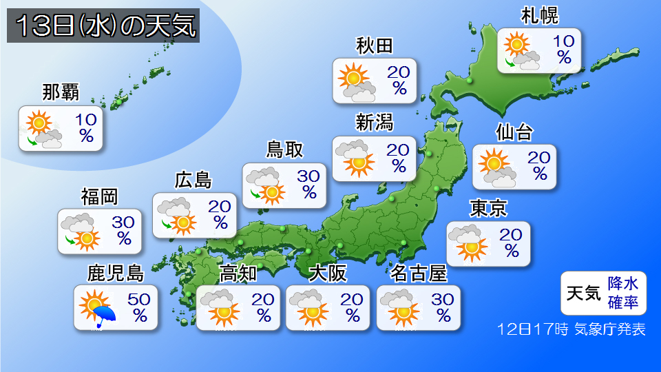
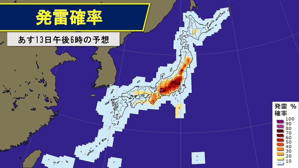
A pressure trough with cold air in the sky is expected to pass near Japan. As a result, atmospheric conditions will become unstable over a wide area, especially inland and along mountains, leading to localized rain clouds and thunderstorms. Those who are going for leisure activities in the mountains should be careful of sudden strong rain, lightning, gusts of wind, and hail even if it is sunny.
Please be aware of changes in the sky when going out as rain clouds may roll in even in the plains.
There will be places in Hokkaido where it will rain temporarily. It's safe to have rain gear when you go out.
It looks like Okinawa will be closed during the rainy season.
Temperatures will be high in northern Japan, and in Hokkaido it will be as sunny as June. However, the temperature will drop after the rain clouds pass, so it's a good idea to wear clothes that are easy to adjust when going out. Temperatures from eastern to western Japan will be typical of this time of year. It looks like it will be a summer day in central Tokyo, with temperatures expected to reach 26 degrees Celsius.
-
Temperatures are rising in various places; unstable atmospheric conditions will continue into tomorrow, 13th (Sunday)
2026/05/12 13:38
-
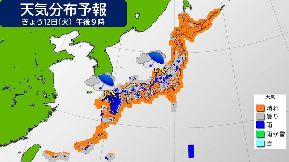
Today, the 12th, a rainy season front extends from the Nansei Islands to the sea near Ogasawara, and although the area around Honshu is largely within an area of high pressure, the situation is such that moist air from behind the high pressure system tends to flow in.
As of 12:00, the temperature has risen in many places, with some places already experiencing summer weather, such as 25.4c in Osaka and 25.1c in Nagoya. Even in Betsukai Town, Hokkaido, where we observed a summer day and a winter day yesterday, the temperature reached 27.4 degrees Celsius. In many places, temperatures will rise further in the afternoon.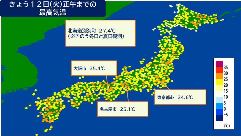
Except for Okinawa and Amami, most places are sunny, but in the afternoon, it will likely rain in Kyushu from the evening onwards from the west. In addition, strong cold air for this time of year will flow into the sky, making the atmosphere unstable, and it is likely that there will be showers in places in the afternoon. Furthermore, the probability of lightning occurring is high mainly in inland areas and along mountains in eastern and northern Japan. Please be careful of sudden thunderstorms and gusts of wind such as tornadoes. It will rain easily in Okinawa.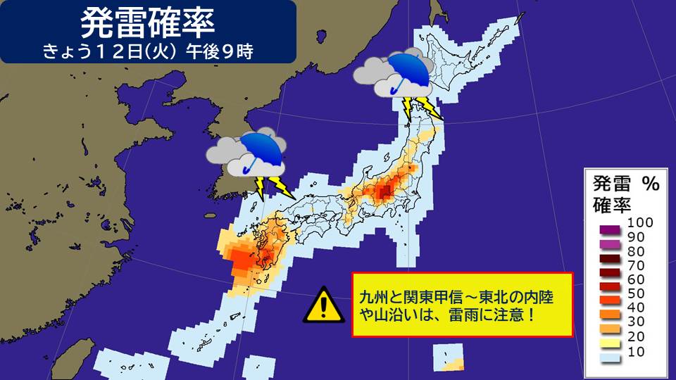

This situation is likely to continue into tomorrow. The probability of lightning occurring is high in the Kinki and Tohoku regions especially in the afternoon when temperatures rise, exceeding 80% in some areas. Please continue to be careful of sudden rain, thunderstorms, and gusts of wind such as tornadoes.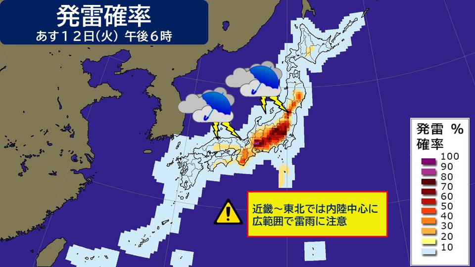
-
Temperatures are rising in various places; unstable atmospheric conditions will continue into tomorrow, 13th (Sunday)
2026/05/12 13:29

-
Today, the 12th, a rainy season front extends from the Nansei Islands to the sea near Ogasawara, and although the area around Honshu is largely within an area of high pressure, the situation is such that moist air from behind the high pressure system tends to flow in.
As of 12:00, the temperature has risen in many places, with some places already experiencing summer weather, such as 25.4c in Osaka and 25.1c in Nagoya. Even in Betsukai Town, Hokkaido, where we observed a summer day and a winter day yesterday, the temperature reached 27.4 degrees Celsius. In many places, temperatures will rise further in the afternoon.
Except for Okinawa and Amami, most places are sunny, but in the afternoon, it will likely rain in Kyushu from the evening onwards from the west. In addition, strong cold air for this time of year will flow into the sky, making the atmosphere unstable, and it is likely that there will be showers in places in the afternoon. Furthermore, the probability of lightning occurring is high mainly in inland areas and along mountains in eastern and northern Japan. Please be careful of sudden thunderstorms and gusts of wind such as tornadoes. It will rain easily in Okinawa.

This situation is likely to continue into tomorrow. The probability of lightning occurring is high in the Kinki and Tohoku regions especially in the afternoon when temperatures rise, exceeding 80% in some areas. Please continue to be careful of sudden rain, thunderstorms, and gusts of wind such as tornadoes.
-
Atmospheric instability will continue from this afternoon until tomorrow.Beware of showers inland and along the mountains in the Tokai and Tohoku regions.
2026/05/11 15:11

-
Today, the 11th (Monday), the rainy season front is stationary from the Nansei Islands to the Ogasawara Islands. The area around Honshu is widely covered by high pressure.
Active rain clouds are spreading near the Nansei Islands, and in Nakasuji, Tarama Village, Miyako District, Okinawa Prefecture, 37.5 mm of heavy rain was observed in the hour up to 10:39 a.m. Rainy conditions are expected to continue in the Nansei Islands into tonight.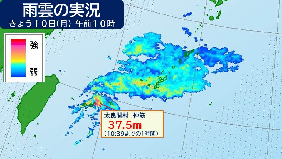
Also, moist air is flowing into Honshu from the south behind the high pressure system, and strong cold air will flow into the upper atmosphere for this time of year.
As a result, the atmospheric condition will be unstable in the afternoon, so please be careful of showers and thunderstorms especially along the mountains and inland areas of Tokai and Tohoku.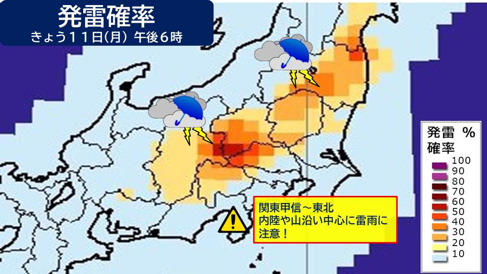
The same pressure distribution will occur near Japan tomorrow, the 12th (Tuesday), and the atmosphere is likely to remain unstable.
Please be careful of sudden rain and thunderstorms mainly in the afternoon, mainly in eastern and northern inland Japan.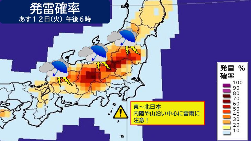
If you feel the following changes, it is a sign that a cumulonimbus cloud is approaching. Heavy rain and thunder will soon arrive. There is also a risk of strong wind gusts such as tornadoes.
+Pitch black clouds are approaching
+I can hear the sound of thunder
+A cold wind suddenly blows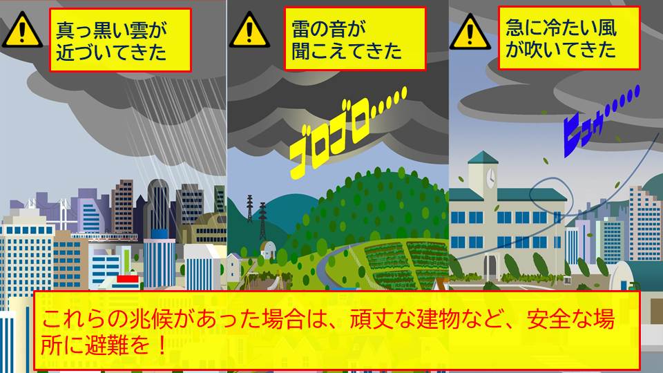
If you notice any of these signs, be careful as the area directly under the tree is not suitable as an evacuation site due to the danger of side lightning strikes. Immediately evacuate to a safe place, such as a sturdy building or underground mall.
-
Weather for the week: High temperatures near Honshu, unstable and changeable weather; Okinawa is closed during the rainy season
2026/05/11 07:36
-
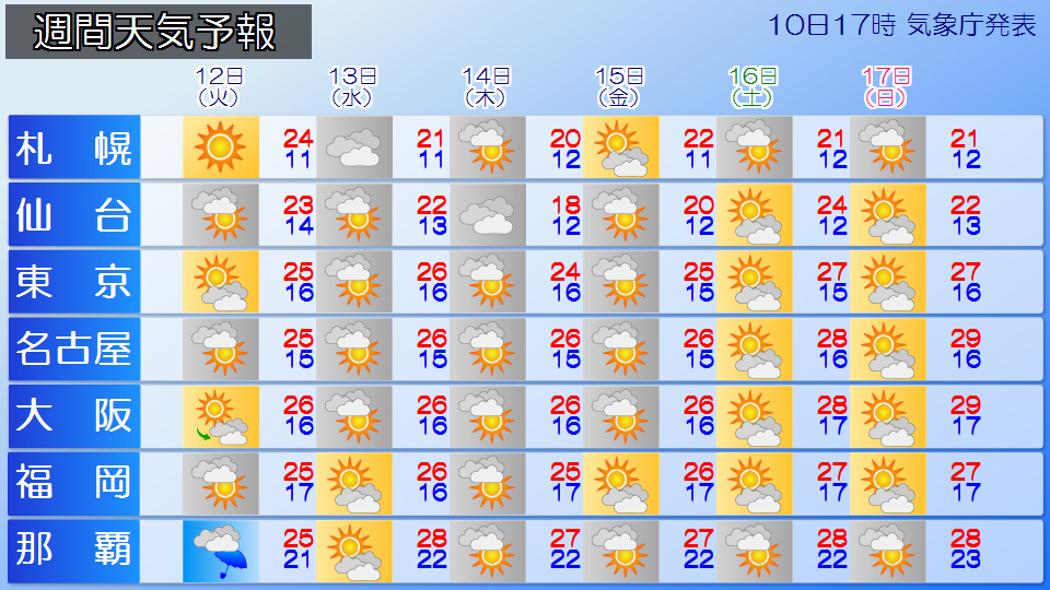
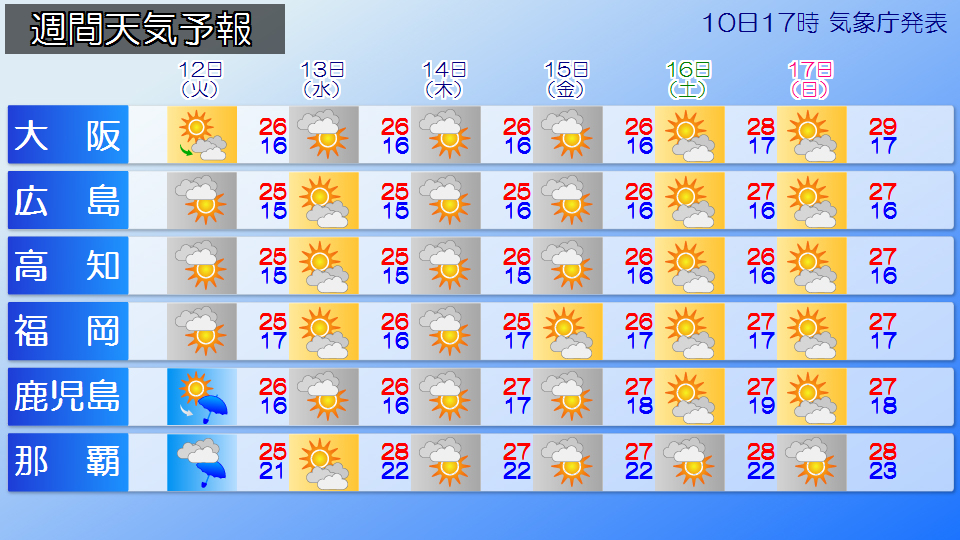
From now on, there will be many days when the area around Honshu will be covered by high pressure, and temperatures will be higher than average nationwide. The maximum daytime temperature will be around 25 degrees Celsius, and temperatures are likely to trend upward into the second half of the week.
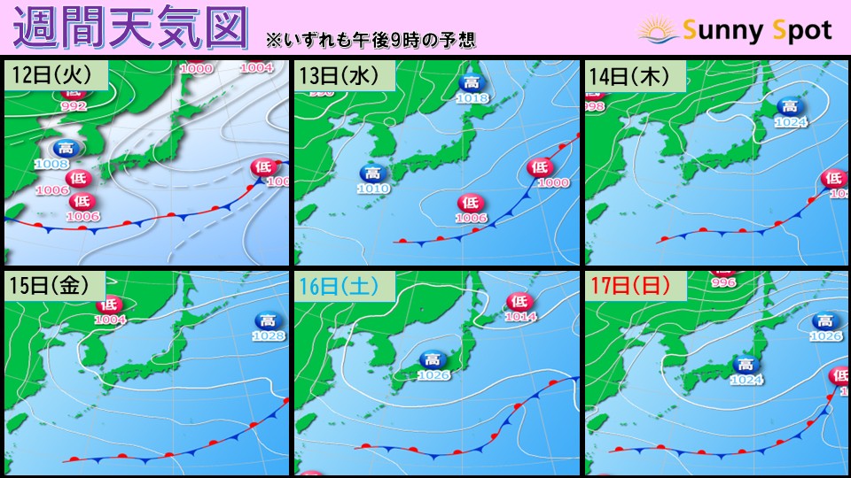
On the weekend, there may be some places where the daytime maximum temperature is 30c. The predicted maximum temperature in Nagoya and Osaka on Sunday the 17th is 29 degrees Celsius, one step before midsummer day, in Kofu it is expected to be 31 degrees Celsius, and in Takayama City, Gifu Prefecture, it is expected to be 30 degrees Celsius.
Summer hasn't really started yet, but please be careful not to get heatstroke. It is best to take precautions such as hydrating frequently, taking appropriate breaks, and turning on the air conditioner indoors rather than holding back.
In addition to the rise in daytime temperatures, cold air frequently flows into the skies near Honshu, so there will be many days when the atmospheric conditions will be unstable, especially inland and along the mountains. From tomorrow, the 12th (Tuesday), there may be localized rain and thunderstorms in inland Honshu due to the influence of cold air in the upper atmosphere. Even if there is no umbrella symbol in the weather forecast, be careful of sudden rain or thunderstorms in the afternoon. Depending on the degree of development of rain clouds, severe phenomena such as lightning strikes and gusts of wind may occur, so it is necessary to pay attention to changes in the sky pattern.
The rainy season front will gradually move far south of Japan, so there will be many relatively sunny days in Okinawa and Amami. It looks like it will be a break during the precious rainy season.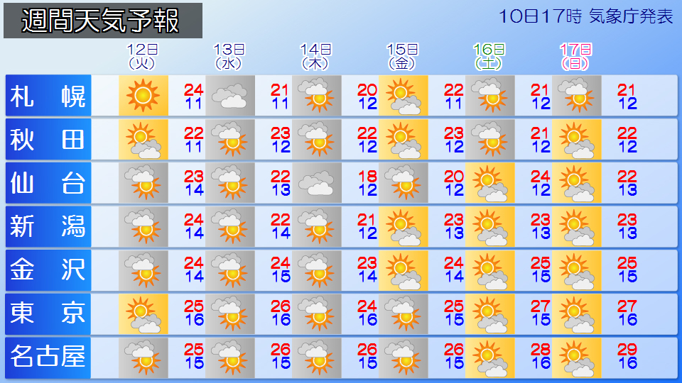
-
Today's weather (Monday 11th): Clear skies around Honshu; watch out for sudden rain and thunderstorms inland and along the mountains in the afternoon
2026/05/11 07:08
-
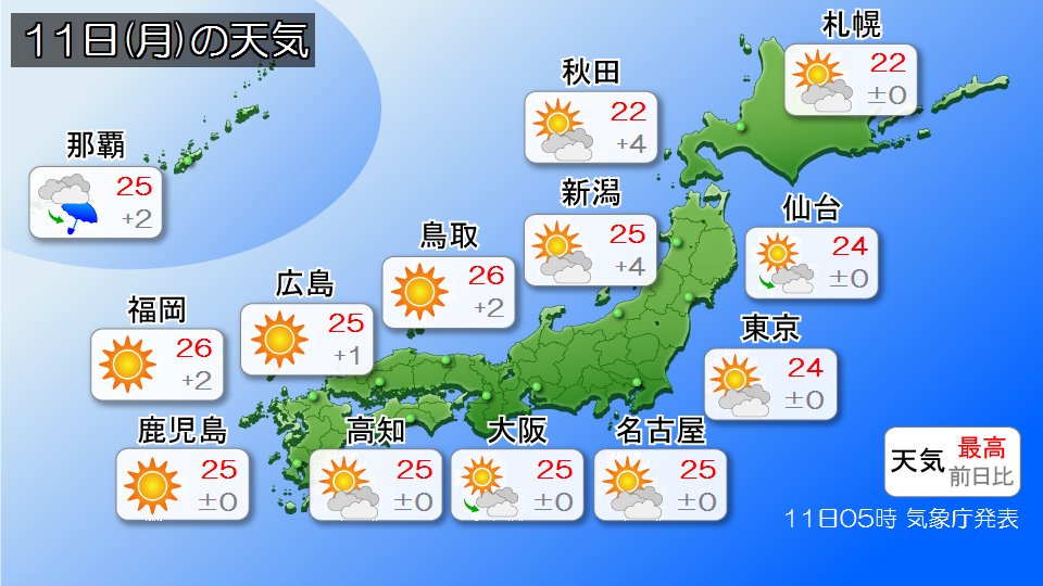
Today, the 11th (Monday), the end of the week, the area around Honshu will continue to be within the area of high pressure. Meanwhile, the rainy season front remains stationary in the south of Japan.
It will be bright and sunny in many areas around Honshu. The maximum temperature during the day is expected to be around 25c in many places, so it will be a sunny day without the need for a jacket. In inland areas, the temperature difference between morning and afternoon tends to be large, so be sure to dress appropriately and stay in shape.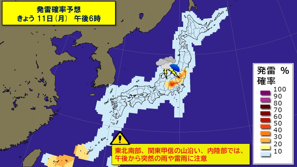
However, in the afternoon, atmospheric conditions will be unstable mainly in inland areas and along the mountains of eastern Japan due to the influence of cold air in the upper atmosphere. In inland areas such as southern Tohoku and northern Kanto, there is a high probability of lightning occurring, and thunderclouds are likely to develop and the weather may change suddenly. Even if there is no umbrella symbol in the weather forecast, be careful of sudden rain or thunderstorms.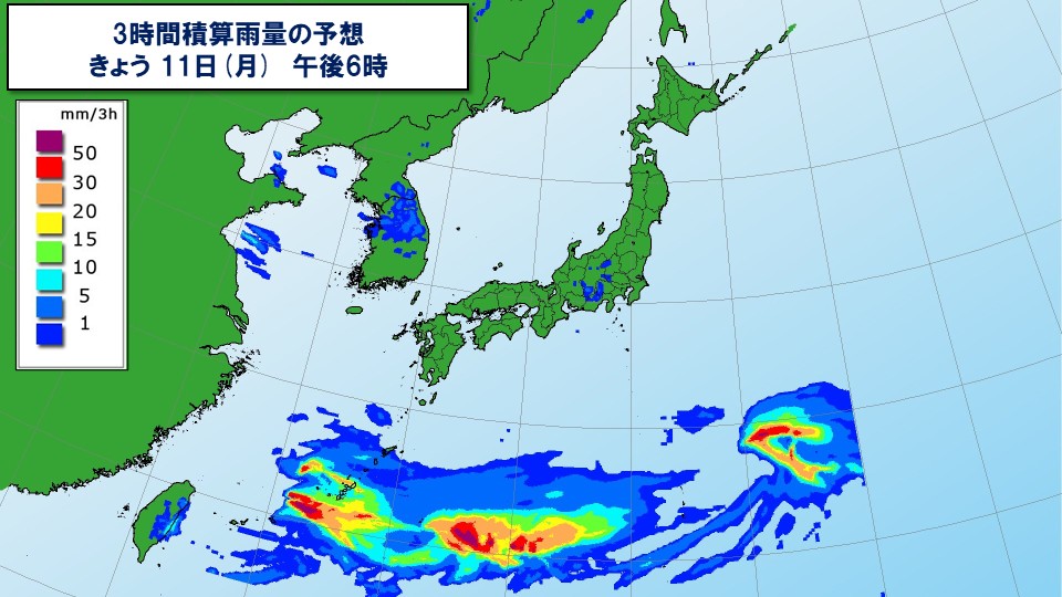
Okinawa and the Ogasawara Islands will likely have a rainy day due to the influence of the rainy season front. There is a risk of localized heavy rain accompanied by thunder, so please be careful of flooding of low-lying areas, landslides, and rising river waters.
-
Tomorrow 11th (Monday) Kanto region: Sunny mark, but beware of showers
2026/05/10 17:58
-
The high pressure system that brought sunshine to Honshu today will move away to the east of Japan from tonight onwards.
Tomorrow, the 11th (Monday), there will be active rain clouds over Okinawa and the Ogasawara Islands, which are affected by the rainy season front, but sunshine is expected to reach a wide area from northern Japan to western Japan.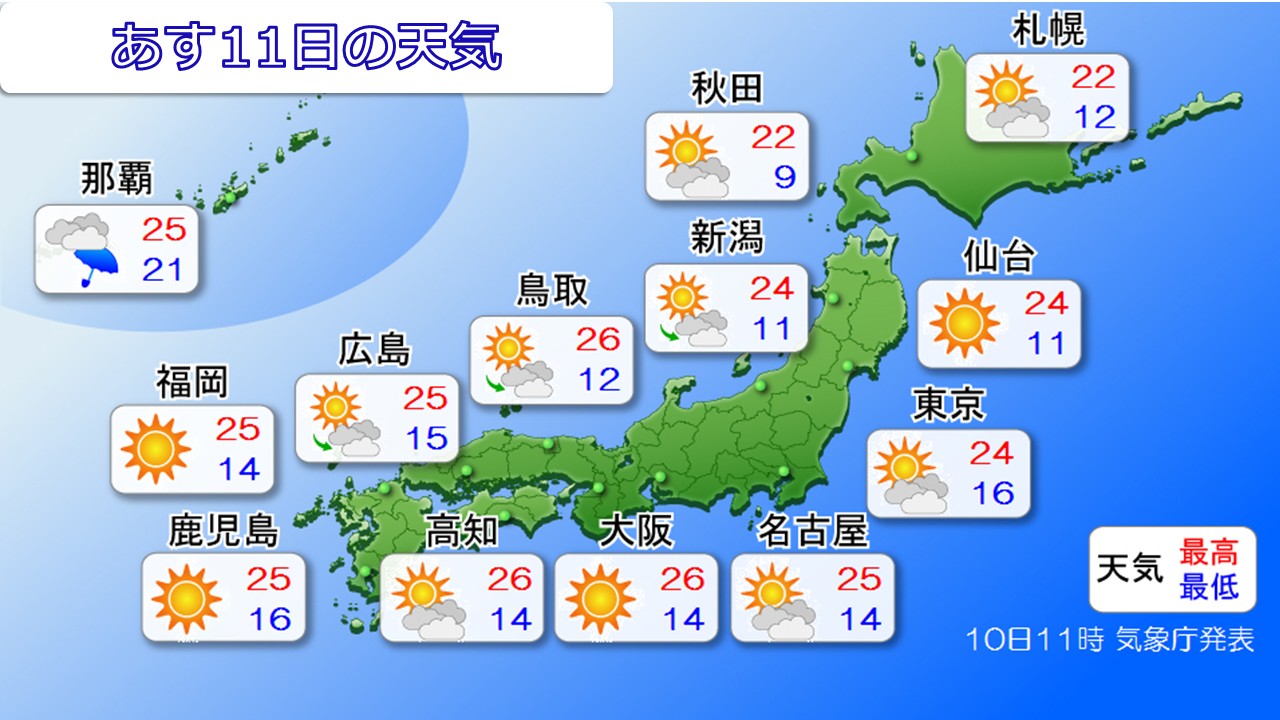
The weather mark says it's sunny, but we can't let our guard down in the Kanto region.
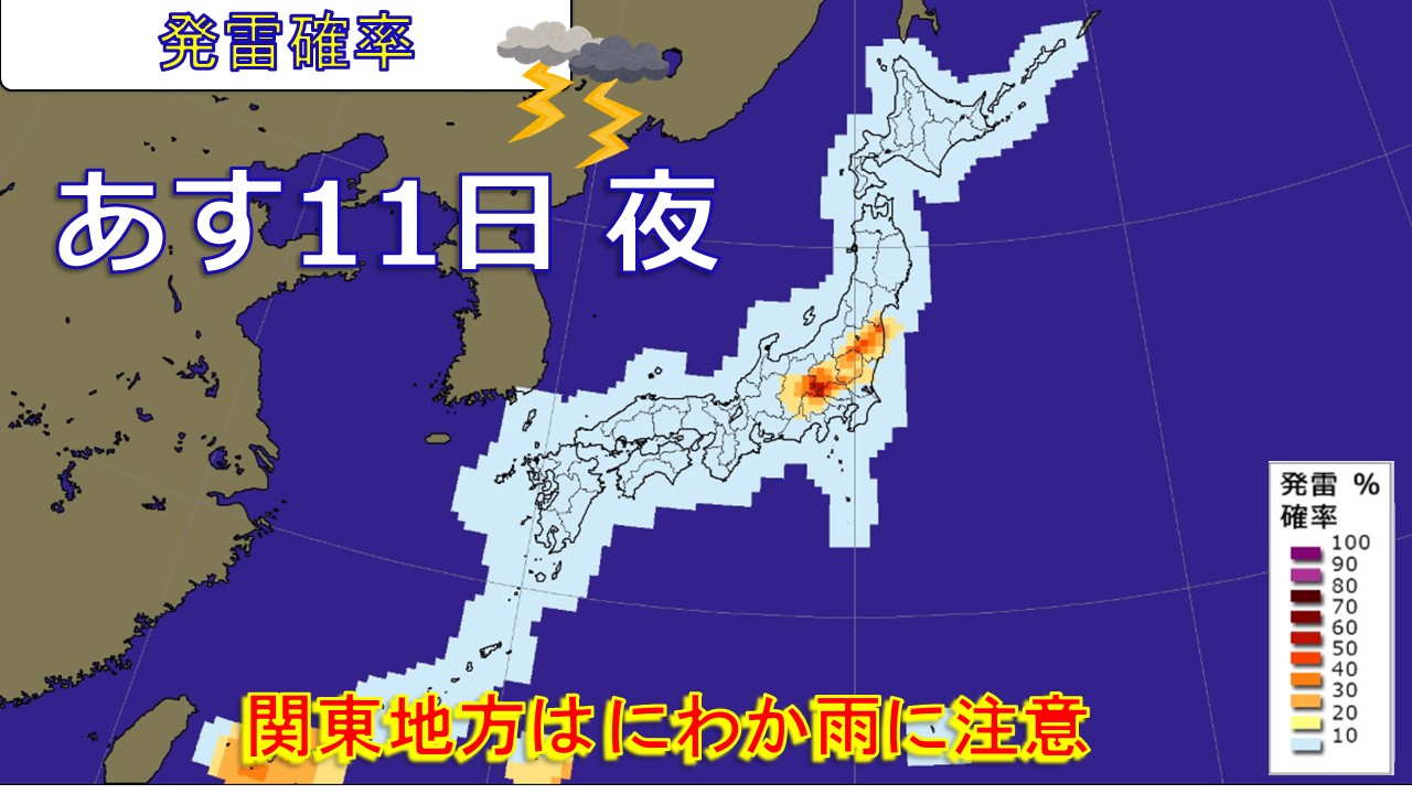
It will enter the rear of the high pressure system, bringing in warm and humid air with southerly winds, and in addition to that, the upper atmosphere is expected to have cold air moving southward for this time of year.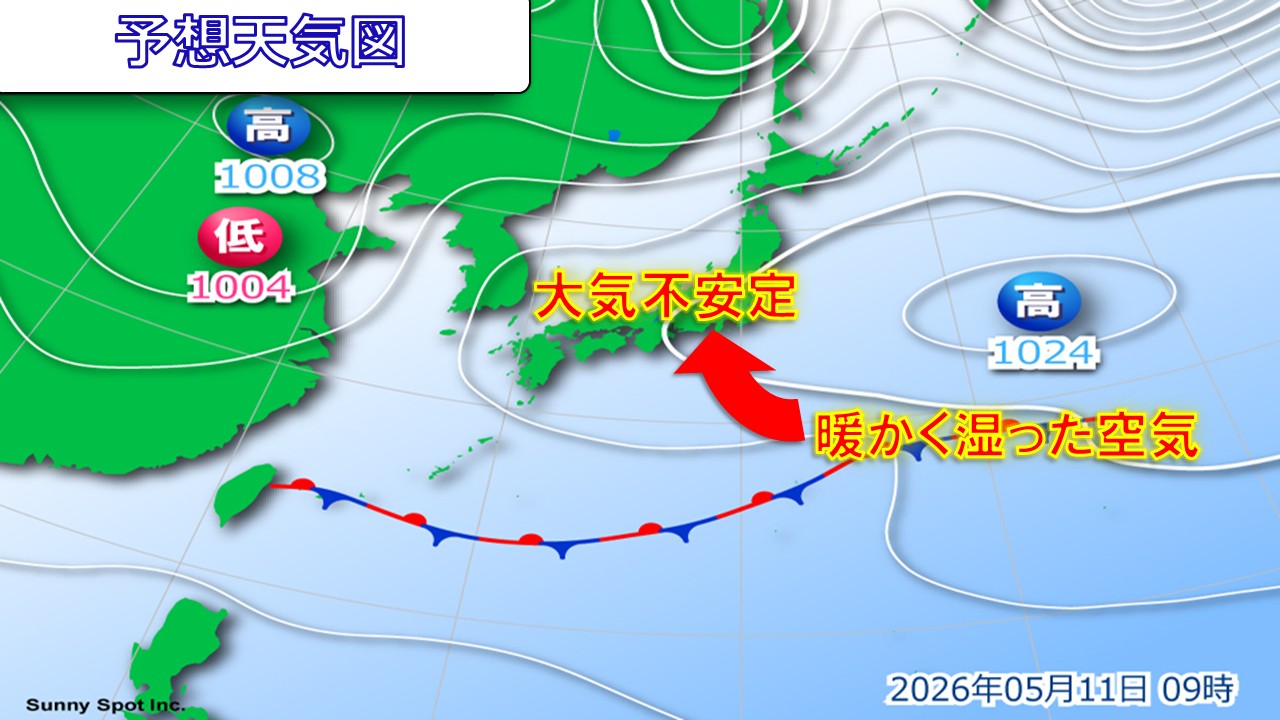
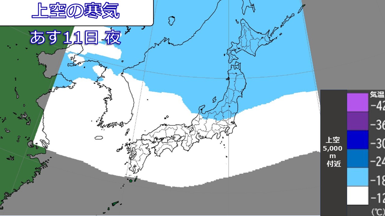
As a result, atmospheric conditions will become unstable, and the probability of lightning strikes will continue to be high, especially in the afternoon. There is a possibility of localized light showers.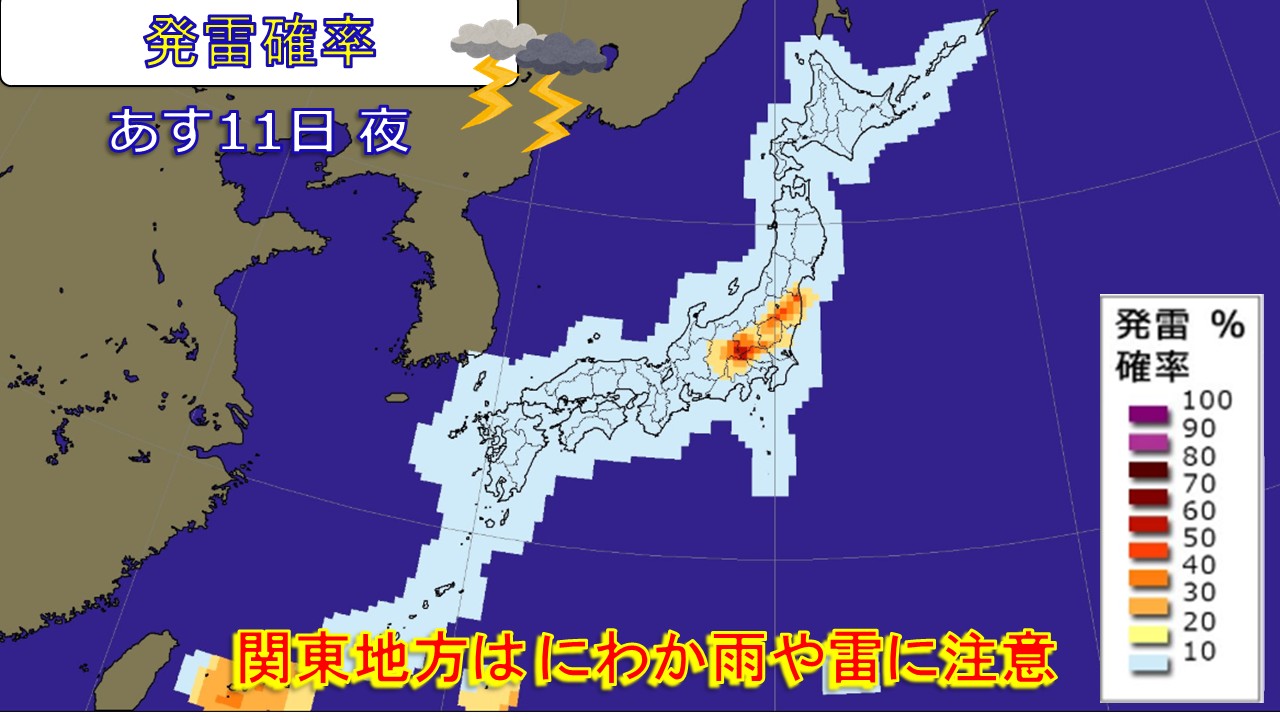
This week, the temperature difference between the sky and the ground will increase, and the atmospheric conditions will continue to be unstable, so it's a good idea to carry a folding umbrella in your bag to avoid getting wet in the sudden rain.
-
There is a risk of heavy rain in the Ogasawara Islands from tonight until late tomorrow night on the 11th. Be careful of landslides and rising river waters.
2026/05/10 12:17
-
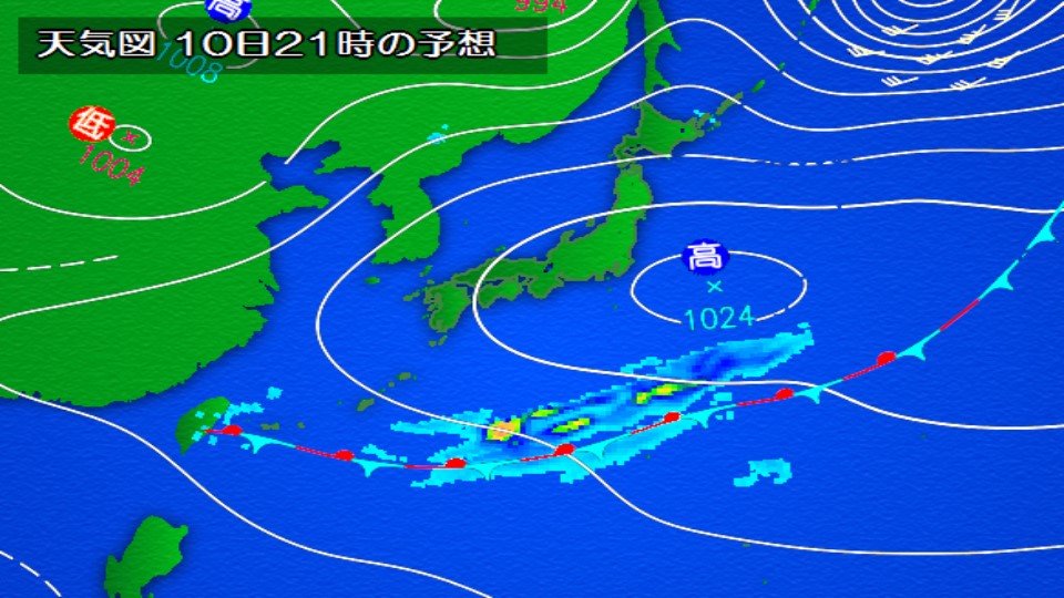
Currently, there is a front in the south of Japan, extending east-west from the Nansei Islands to the Ogasawara Islands.
Atmospheric conditions in the Ogasawara Islands are expected to become unstable until tomorrow, the 11th (Monday), as warm, humid air flows towards the front. It will rain intermittently, and there will be periods when the rain becomes heavier and may be accompanied by thunder.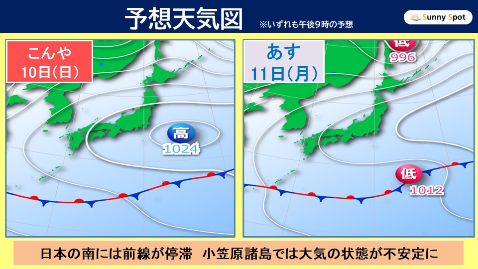
Please be careful of landslides in the Ogasawara Islands from early evening today, the 10th (Sunday) to late evening on the 11th (Monday) tomorrow.
Also, please be aware of rising river water levels until noon today, the 10th (Sunday).
If the rain clouds develop more than expected, or if the developed rain clouds continue to cover the area, there is a possibility of warning-level heavy rain.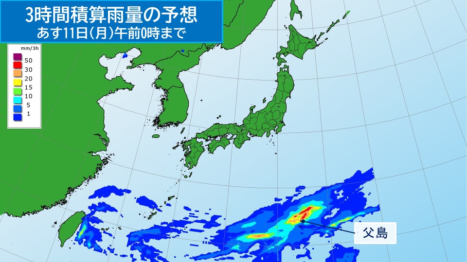
From early morning until dawn on the 11th (Monday), there will be heavy rain accompanied by thunder in some places.
[Rain Forecast]
Expected 1-hour precipitation today, the 10th (Sunday), is expected to be high in some places,
Ogasawara Islands 20 mm
tomorrow, the 11th (Monday). The predicted 24-hour precipitation from 6:00 a.m. on the 10th (Sunday) to 6:00 a.m. on the 11th is high in the Ogasawara Islands.
Ogasawara Islands 80mm
Then, the predicted 24-hour precipitation from 6:00 on the 11th to 6:00 on the 12th will be high,
Ogasawara Islands 60mm
[Disaster prevention matters]
Please be careful of landslides in the Ogasawara Islands from early evening today, the 10th (Sunday) to late evening tomorrow, the 11th (Monday).
Please be careful of rising river water levels until noon today, the 10th (Sunday).
-
Today's weather on the 10th (Sunday): Great weather for going out in a wide area; rainy skies continue in the Nansei Islands
2026/05/10 06:46
-
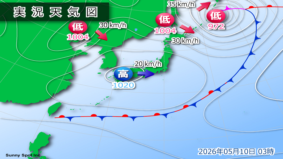
On Mother's Day, the 10th (Sunday), the area around Japan will be covered by a migratory high pressure system. Therefore, it looks like it will be a day where you can enjoy a wide range of outings. Meanwhile, the rainy season is expected to continue in the Nansei Islands.

In Hokkaido, clouds are expected to remain on the Sea of Okhotsk side until morning, but the weather will gradually improve and the blue sky will spread throughout the day.
The weather will not deteriorate from Tohoku to Kyushu, and it looks like it will be a calm day. The weather will be fine for going out.
During the day, there are many places where the temperature is typical of this time of year, and there are some places where it can be so hot that you sweat a little when you move during the day. It gets colder in the morning, so the temperature difference between morning and evening and daytime increases. Please take care of the temperature difference by adjusting your clothing.
Meanwhile, the rainy season continues in the Nansei Islands. It will be a cloudy and rainy day, and the weather will not be refreshing. It's safe to have rain gear when going out.
-
Atmospheric conditions are unstable from northern Japan to Hokuriku; storms are feared along the coast of northern Japan; rain continues in Okinawa
2026/05/09 12:06
-
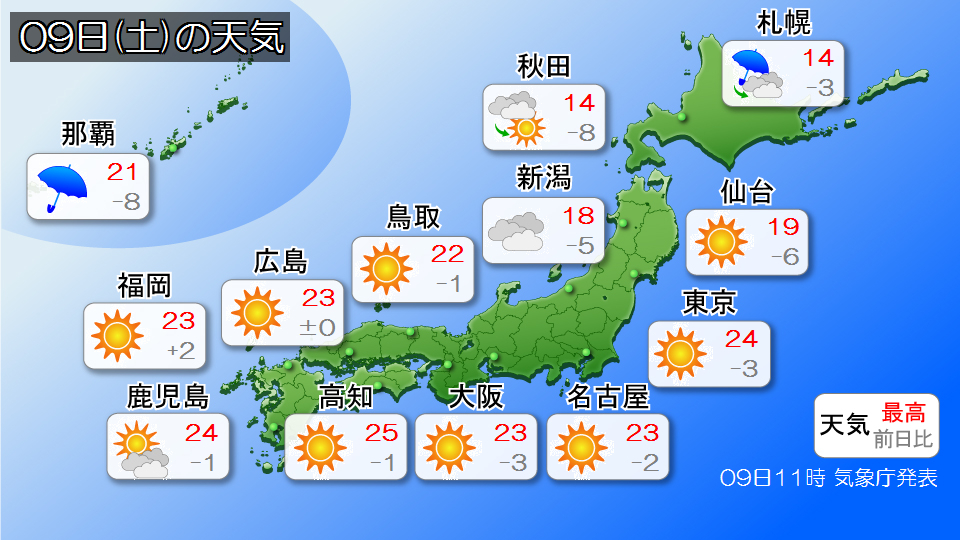
Two low pressure systems are moving near Hokkaido today, the 9th (Saturday). One is passing near Hokkaido, and the other is expected to move northeastward, accompanied by a front, and continue to develop near the Kuril Islands.
Low pressure systems are accompanied by strong cold air in the upper atmosphere, causing unstable atmospheric conditions mainly on the Sea of Japan side from northern Japan to Hokuriku. In addition, winds are increasing, especially along the coasts of northern Japan, and storm warnings have been issued in some places.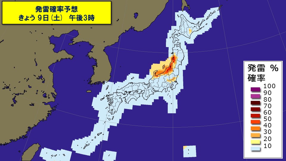
On the Sea of Japan side from Hokuriku to Tohoku, please be careful of sudden rain and thunderstorms even after the rain has stopped. Depending on the degree of development of rain clouds, severe phenomena such as lightning, tornadoes, strong gusts of wind, and hail may occur, so please be aware of changes in the sky pattern. Thunderclouds are expected to develop easily in some parts of the inland areas of the northern Kanto region, so please be careful of sudden changes in the weather.
Also, because the spacing between the isobar lines is narrow, there is a risk of extremely strong winds blowing mainly along the coast of northern Japan. In coastal areas of the Tohoku region, maximum instantaneous wind speeds are expected to reach 30 meters, so please be careful of strong winds and high waves, and be aware of the impact on traffic.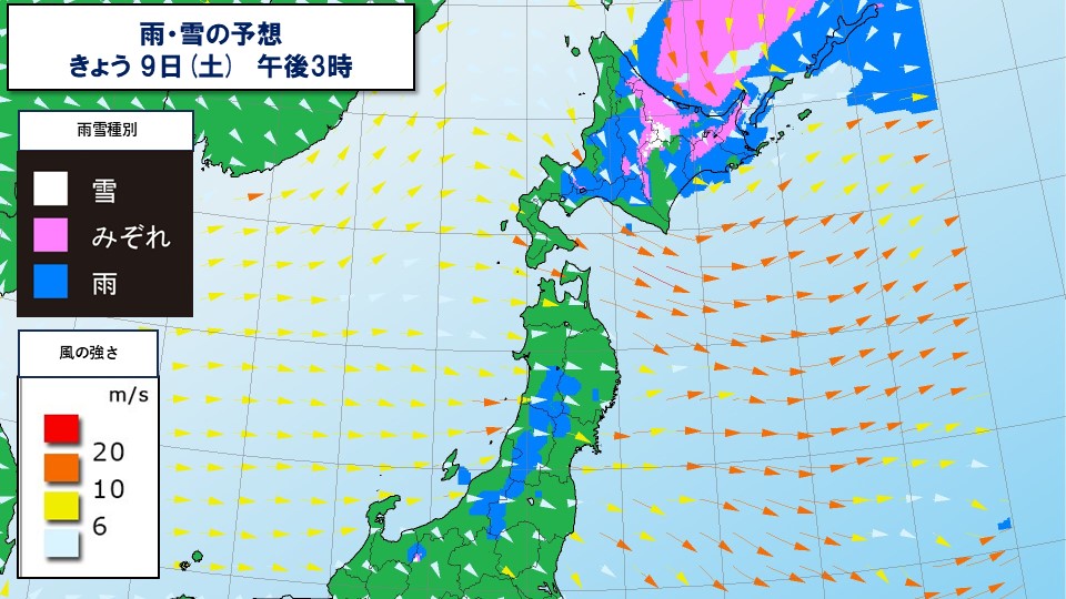
It seems that there will be some snow in Hokkaido due to the cold air above. The area of rain and snow is expected to gradually narrow into the evening, but please be careful of deteriorating road conditions in inland areas and along the mountains of northern Hokkaido.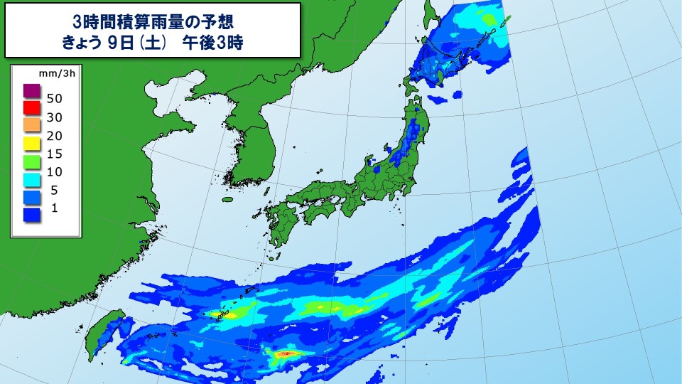
In Okinawa, rain will continue throughout the day due to the rainy season front. There is a risk of localized heavy rain accompanied by lightning, so please be careful of landslides and flooding of low-lying areas.


