


-
Weather today, the 14th (Tuesday): Extreme heat from Kanto to the west
2026/07/14 07:12
-
Western Japan is expected to be covered in high pressure. A low pressure system with cold air in the sky is expected to slowly move north over the southern coast of Hokkaido.
From the Kanto region to the west, strong sunlight will shine, and temperatures are expected to rise to around 35c during the day. Inland areas can become dangerously hot, exceeding body temperature. Temperatures will be higher than yesterday in many places. Please be careful about heat stroke. In addition, there is a risk of sudden changes in the weather mainly along the mountains in the afternoon.
Northern Japan and Hokuriku will be covered in clouds and the weather will not be refreshing. There is a possibility of rain showers in places, mainly on the Sea of Japan side, so please bring an umbrella with you.
-
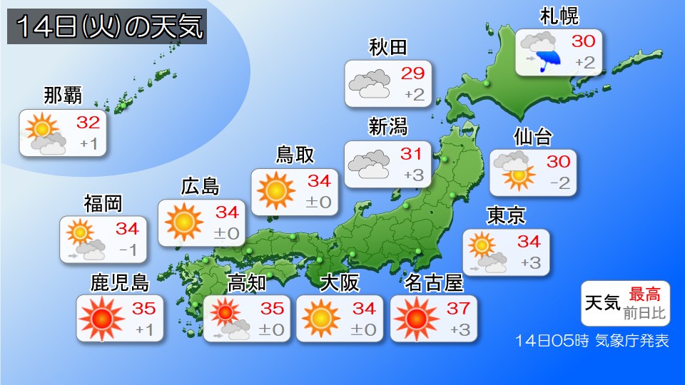
Severe heat from western Japan to eastern Japan - 34 degrees Celsius expected in central Tokyo - be wary of heatstroke
2026/07/14 07:11
-
Today, the 14th (Tuesday), many places from western Japan to eastern Japan will be covered in high pressure and will be sunny, with sunshine reaching many places. Yesterday, the 13th, was hot mainly in western Japan, but today, the 14th, the heat will expand to eastern Japan, and it will be an extremely hot day in many places from western to eastern Japan.
The predicted maximum temperature in each region is 30c in Sapporo, 30c in Sendai, 34c in Tokyo, 32c in Kanazawa, 37c in Nagoya, 34c in Osaka, 35c in Kochi, and 34c in Fukuoka.
In addition, Maebashi City in Gunma Prefecture, Kumagaya City in Saitama Prefecture, Chichibu City, and Miyazaki City in Miyazaki Prefecture are forecast to reach 37 degrees Celsius, with some places from western Japan to eastern Japan expected to experience dangerous heat exceeding body temperature, especially in inland areas.
This will be the hottest day of the year in central Tokyo, so please take precautions against the heat.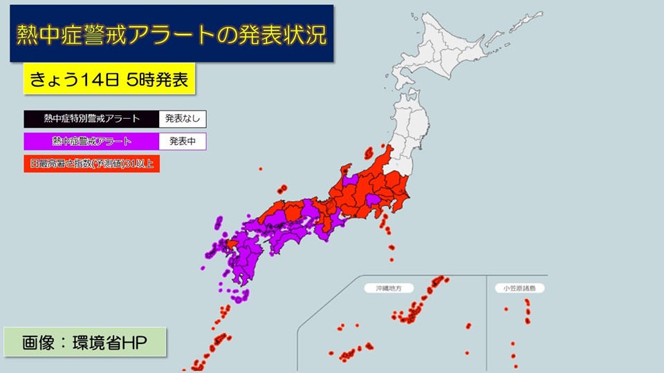
The Ministry of the Environment and the Japan Meteorological Agency have issued heatstroke warning alerts from Kyushu to Chubu, targeting 17 regions. This will be the first announcement of this year in Yamanashi, Mie, Toyama, Tottori, Tokushima, and Kochi prefectures.
#Area covered by heat stroke warning alert
Kagoshima (excluding Amami region), Miyazaki prefecture, Kumamoto prefecture, Nagasaki prefecture, Oita prefecture, Fukuoka prefecture, Yamaguchi prefecture, Kochi prefecture, Ehime prefecture, Kagawa prefecture, Tokushima prefecture, Hiroshima prefecture, Wakayama prefecture, Military In areas where heatstroke warnings have been issued for Kyoto Prefecture, Toyama Prefecture, Mie Prefecture, and Yamanashi Prefecture, there is a risk of damage to human health due to heatstroke due to significantly higher temperatures.
Please refrain from activities during hot hours as much as possible, and be conscious of taking frequent breaks and replenishing hydration and salt intake.
Also, please use the air conditioner as appropriate to stay indoors in a cool environment, and take precautions against heat stroke indoors.
-
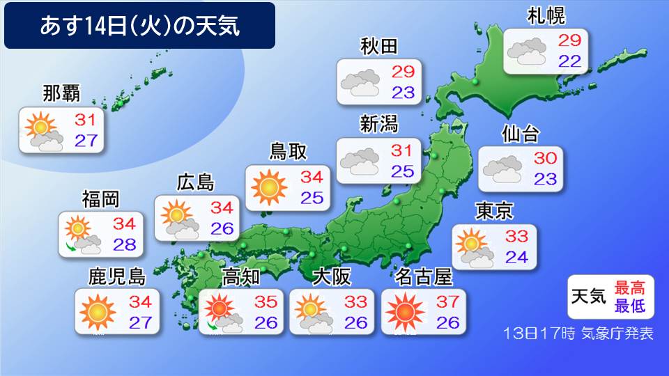
Tomorrow, the 14th (Tuesday), the extremely hot area will expand to the east, with temperatures reaching body temperature in the inland Kanto region and the Tokai region
2026/07/13 18:34

-
Tomorrow, the 14th (Tuesday), the Pacific anticyclone will expand its strength to eastern Japan. The Kanto and Tokai regions, which were cloudy and rainy today, are expected to see sunshine and temperatures to rise significantly.
With the expansion of the Pacific anticyclone, warm air at around 1500m above the ground will also expand eastward. If the weather is sunny, the warm air, which could reach temperatures of over 35 degrees Celsius, is expected to spread not only to western Japan, but also to the Sea of Japan and the Pacific side of eastern Japan.As a result, temperatures will rise in many places compared to today.
Tomorrow, the 14th (Tuesday), sunny areas will expand to the east, and even in eastern Japan, there is a risk of dangerous heat especially in inland areas.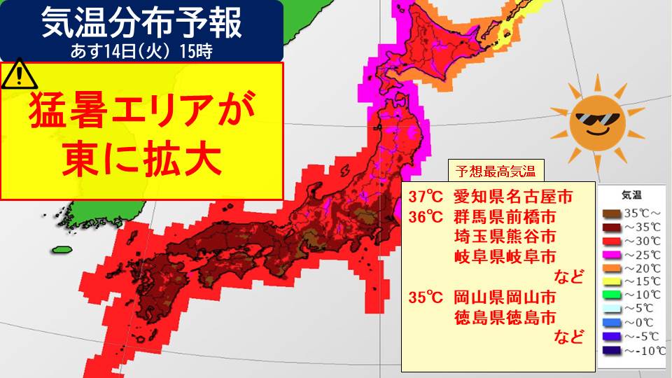
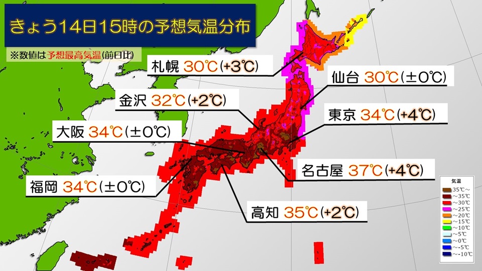
Looking at the distribution of temperature forecasts at 3pm tomorrow, western Japan, the Tokai region, and the Kanto-Koshin region are likely to reach 30 C or higher, except for high-altitude areas. In addition, areas with temperatures above 35 degrees Celsius are expanding in the inland areas and the Nobi Plains.
Temperatures are expected to be significantly higher than today, especially in inland areas, with the highest temperature expected to be 37c in Nagoya City and 36c in Maebashi City, Kumagaya City, Gifu City, etc. Okayama City, Tokushima City, Kochi City, and other cities will experience an extremely hot day with temperatures reaching 35 degrees Celsius, and Osaka City and central Tokyo will also experience temperatures of up to 33 degrees Celsius. The heat can quickly become dangerous, so it is essential to take thorough measures to prevent heat stroke.
Western Japan also continues to experience high temperatures, and there is a possibility that the number of locations with extremely hot days will be the highest this year. The temperature does not drop easily at night, so please be careful of heat stroke both day and night.
-
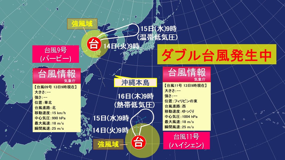
[Breaking news] Typhoon No. 11 has occurred. Double typhoon is occurring. Typhoon No. 9 has changed its shape and is affecting Japan again.
2026/07/13 11:39
-
At 9 a.m. today, the 13th (Monday), the tropical cyclone that was developing to the east of the Philippines became Typhoon No. 11 (Haishen).
The central pressure is 1004hPa, the maximum wind speed near the center is 18m/s, and the maximum instantaneous wind speed is 25m/s.
Typhoon No. 11 is moving slowly westward east of the Philippines with strong winds.
It is expected to slowly move north east of the Philippines and become a tropical cyclone on the 16th (Thursday).
In addition, Typhoon No. 9, which had a major impact on Okinawa the other day, is heading north through northern China, accompanied by strong winds, as of 9 a.m. today, Monday, the 13th.
After making landfall in China, it has weakened in strength, but from now on it will make a U-turn in North China, change its course to the northeast, move into the Yellow Sea tomorrow, the 14th (Tuesday), and the central Japan Sea the next day, the 15th (Wednesday), turning into an extratropical cyclone with a front.
Typhoon No.9 is expected to transform into an extratropical cyclone and then move toward the northern Sea of Japan.
This low pressure system, warm, humid air heading toward the front, and rising temperatures during the day will cause the atmospheric conditions in Japan to become unstable, leading to thunderstorms in some places.
-
Weekly Forecast: Be careful of the intense heat that continues every day and sudden changes in the weather. Heavy rain is expected in Hokkaido in the middle of the week around the 15th.
2026/07/13 07:53
-
From now on, the area around Japan will continue to be covered in warm air. In the regions west of the Tokai region, it will be sunny every day, and with the addition of strong sunlight, the expected maximum daytime temperature is expected to be around 35 degrees Celsius on many days. Since the temperature does not drop much at night, the risk of heatstroke increases both day and night. Please take thorough measures to prevent heat stroke, such as staying hydrated frequently and taking adequate breaks.
It is expected that there will be many days around 30c in northern and eastern Japan as well. Kanto and the Pacific side of Tohoku are susceptible to the influence of humid air from the east, so it tends to be cloudy and the days are likely to continue to be hot and humid.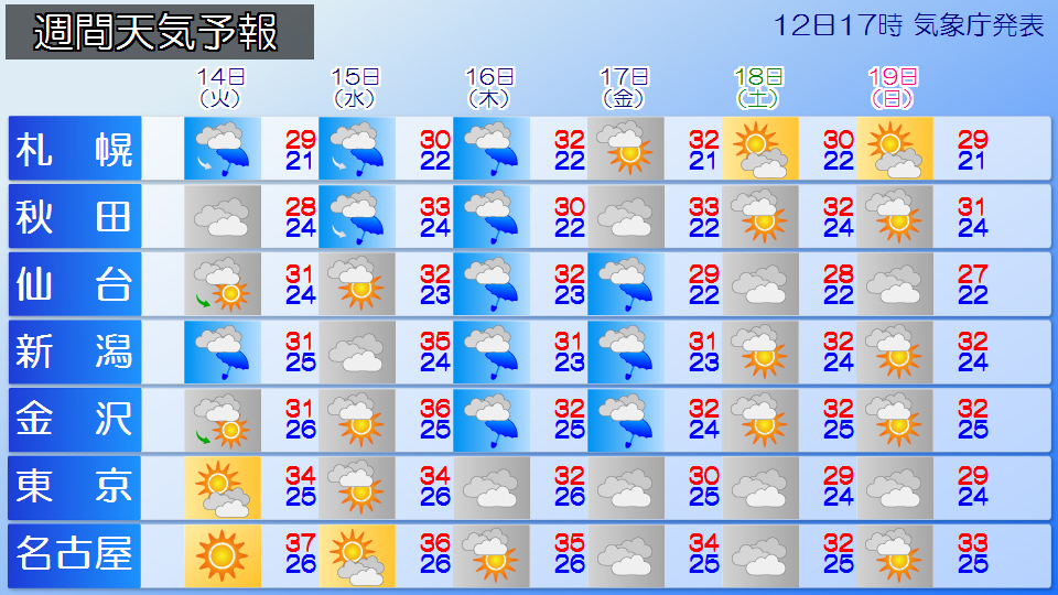
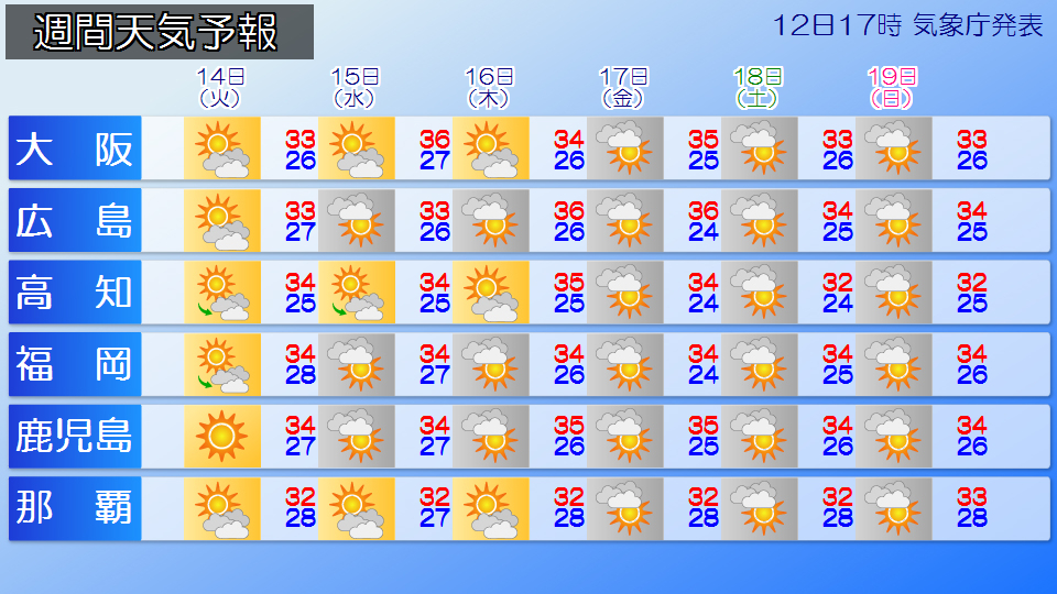
Looking at the weekly weather mark, western Japan has sunny weather every day, and it seems that there will be some days when the sun will reach eastern and northern Japan as well. However, in the afternoon, atmospheric conditions become unstable due to rising temperatures during the day and humid air, and in the afternoon, there is a possibility that sudden rain called ``guerrilla thunderstorms'', thunderstorms, lightning strikes, and violent gusts such as tornadoes may occur mainly inland and along mountains. In particular, if you enjoy outdoor leisure activities such as mountains or rivers, please make every effort to ensure your safety if you see signs of sudden changes in the weather, such as seeing thick black clouds or hearing thunder.
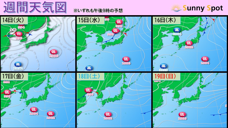
In the middle of the week, from the 15th (Wednesday) to the 16th (Thursday), a low pressure system similar to Typhoon No. 9 is expected to approach Hokkaido. There is a risk of heavy rain in Hokkaido, so please pay attention to the latest weather information that will be updated in the future.
-
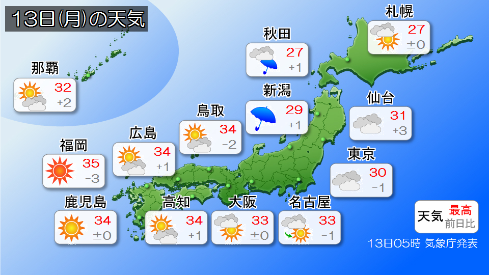
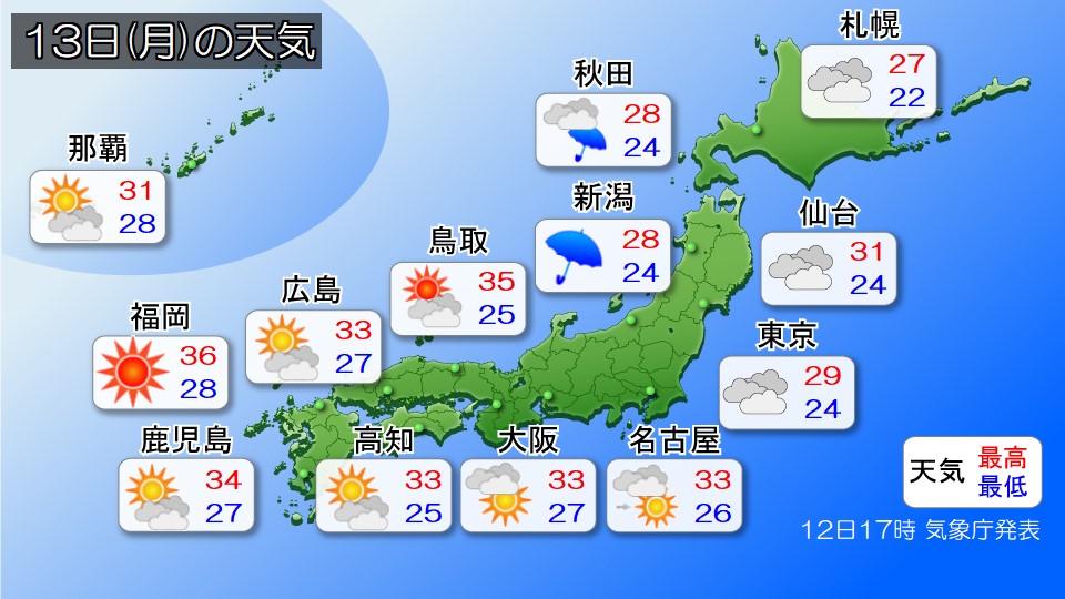
Weather forecast for today, the 13th (Monday): Beware of dangerous heat that exceeds body temperature in western Japan; beware of sudden changes in the weather in the afternoon
2026/07/13 06:59
-
Today, the 13th (Monday), will be the start of the week, and western Japan will be covered in high pressure, making it sunny in many places, making it extremely hot.
It looks like there will be many cloudy and rainy days in Hokuriku, Kanto, and Tohoku.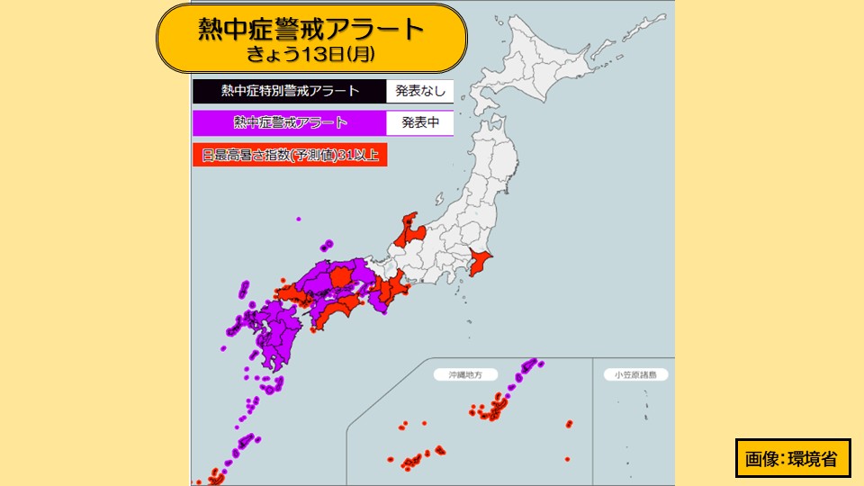
Today, the 13th (Monday), a heatstroke warning alert has been announced for 14 prefectures from the Kinki region to the Kyushu and Amami regions. Dangerously hot weather is expected to occur mainly in western Japan, with predicted maximum temperatures of 38 C in Hita City, Oita Prefecture, and 37 C in Yamaguchi and Hitoyoshi City, Kumamoto Prefecture, which could reach dangerous levels that could exceed body temperature. Additionally, the temperature will not drop much at night, and there are likely to be some places where the minimum temperature from tonight until tomorrow morning will be over 25 degrees Celsius, making it a tropical night.
Please be more careful about heat stroke and take thorough measures such as drinking water frequently, using air conditioning, and taking appropriate breaks.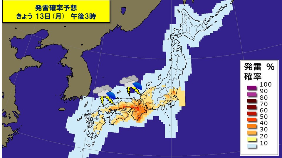
In the afternoon, atmospheric conditions will be unstable in western Japan, especially inland and along the mountains, due to rising daytime temperatures and moist air. Even in areas where there is no umbrella symbol in the weather forecast, please be careful of sudden rain or thunderstorms in the afternoon, as well as strong gusts such as lightning or tornadoes.
Hokuriku, Kanto, and Tohoku will have a lot of clouds, and it looks like it will be a rainy day. In Hokuriku, please be careful of heavy rain accompanied by localized thunder. The maximum daytime temperature is not expected to be as severe as in western Japan, but it will be a hot and humid day with many places around 30 degrees Celsius.
-
Weather for tomorrow 13th (Monday) Heavy rain in Tohoku and Hokuriku, extreme heat warning in western Japan
2026/07/12 18:03
-
Western Japan is expected to be covered in high pressure, and a low pressure system with cold air in the sky is expected to be located on the southern coast of Hokkaido. Additionally, a front that is not depicted on weather maps is expected to form from the southern Tohoku region to the Kanto region.
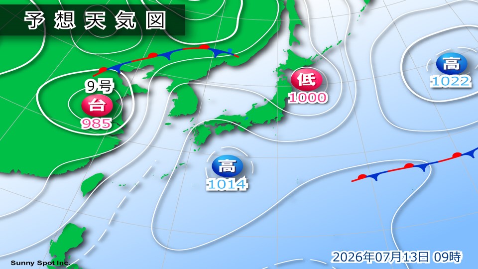
Western Japan is sunny and the strong sun shines down. Dangerous heat exceeding body temperature is expected in inland areas. Temperatures are high, especially in Kyushu and China, so please be careful of heat stroke.
It will be rainy in southern Tohoku, Hokuriku, and Kanto. Rain clouds are likely to develop, especially on the Sea of Japan side, and there is a risk of heavy rain. Please take precautions against landslides, river flooding, and road flooding. There are a lot of clouds in Hokkaido, but the unstable conditions are expected to improve compared to today. However, be careful of rain showers along the mountains.
-
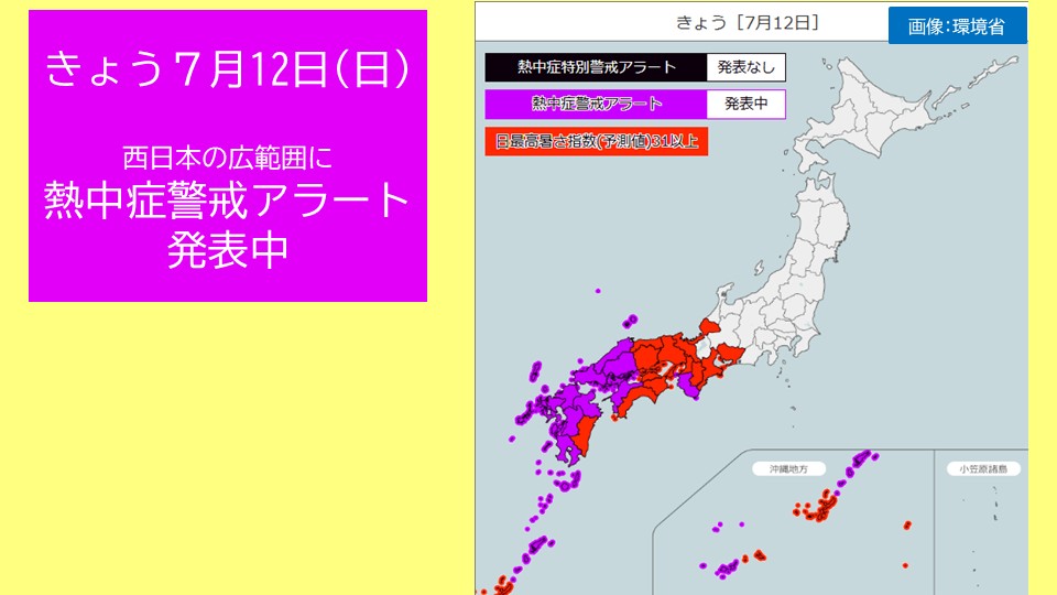
[Breaking news] Rainy season ends in Shikoku region; beware of intense heat
2026/07/12 12:19
-
Today, the 12th, the
meteorological observatory announced that the rainy season appears to have ended in the Shikoku region.
Shikoku region: Around July 12th (5 days earlier than normal)
*The announcement of the end of the rainy season is preliminary. It may be revisited and revised in the fall.
Today, the Shikoku region is covered by the Pacific anticyclone and is mostly sunny. In Takamatsu City, Kagawa Prefecture, the temperature was 33.6 degrees Celsius by 12:00, making it extremely hot as the rainy season ends.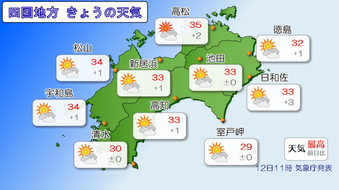
For this reason, heat stroke warning alerts have been announced in multiple regions in western Japan.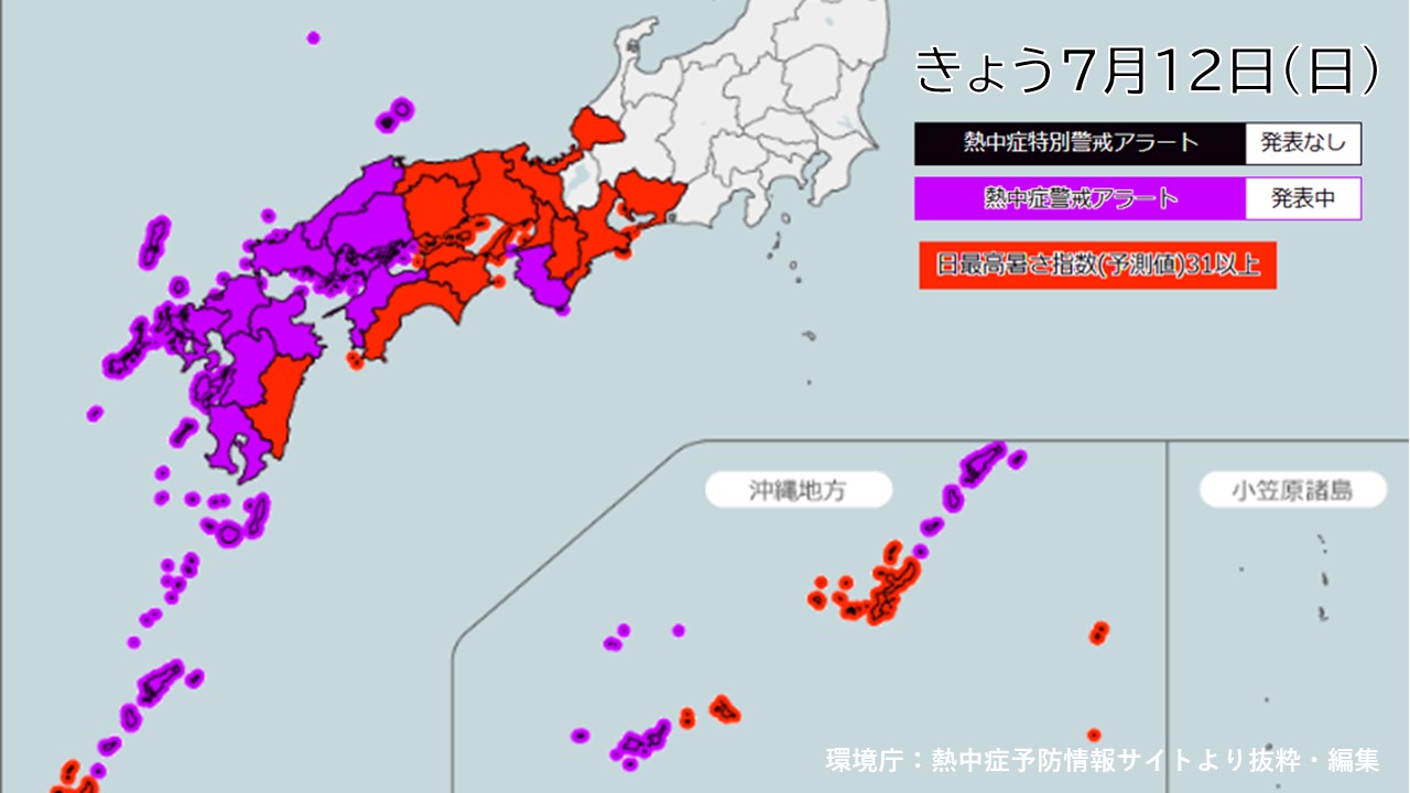
For the next week, the Shikoku region is expected to be covered by the Pacific anticyclone and have many sunny days.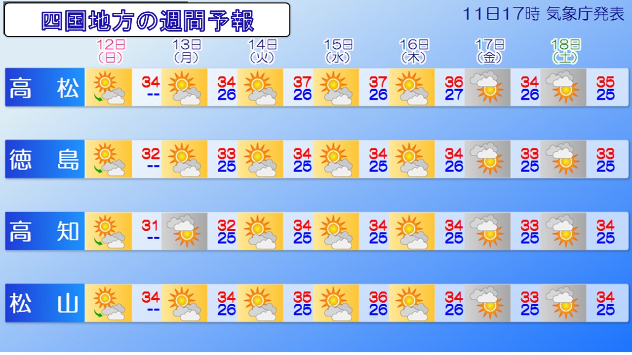
The middle of the week is expected to be particularly hot, with maximum daytime temperatures exceeding body temperature. Please take care of your health.
-
High temperatures will continue in eastern and western Japan from now until around the 18th. Be careful of heatstroke.
2026/07/12 06:33

-
On the 11th, the Japan Meteorological Agency announced general weather commentary regarding high temperatures.
From around the 14th (Tuesday) to the 18th (Saturday) in eastern Japan, and around the 18th (Saturday) in western Japan, there will be days covered by high pressure and warm air, so it is expected that there will be some extremely hot days with maximum temperatures of 35 degrees Celsius or higher.
Please take care of your health, such as preventing heat stroke, and managing your crops and livestock.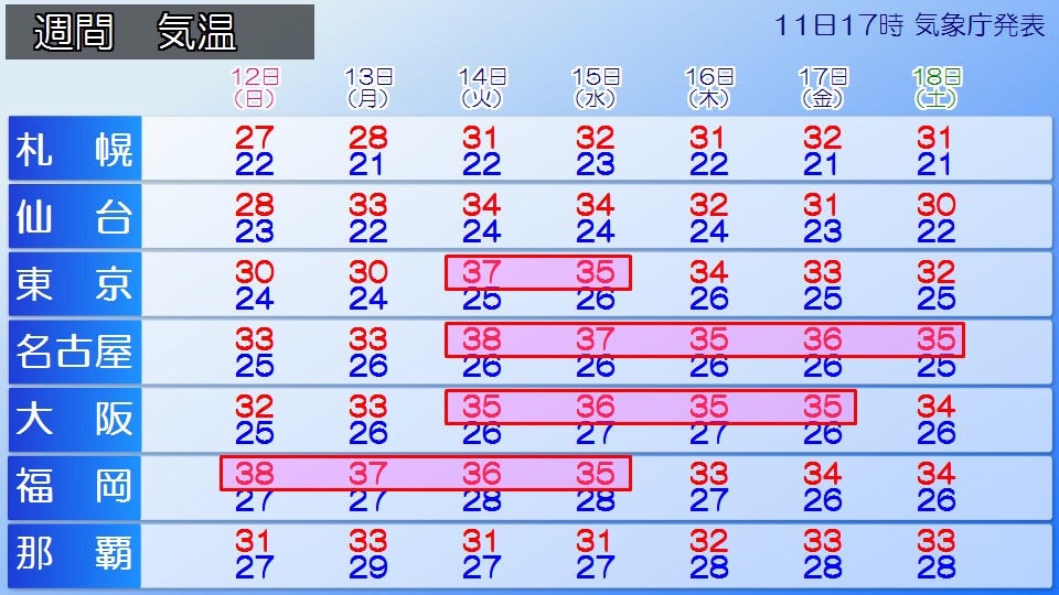
Looking at the forecast for the maximum temperature for the next week, it looks like Fukuoka Prefecture will continue to experience extremely hot days with temperatures above 35c until around Wednesday the 15th. There will also be days when the temperature is 38 C or 37 C, which is higher than your body temperature, so it is essential to take precautions against heatstroke.
Tokyo, Nagoya, and Osaka will initially experience midsummer days with temperatures above 30c, and from around the 14th (Tuesday) it is expected to become an extremely hot day with temperatures above 35c.
Especially in Tokyo, the temperature will rise from 30 degrees Celsius on the 13th (Monday) to 37 degrees Celsius on the 14th (Tuesday), rising by 7 degrees Celsius over the next day, so the temperature will rise rapidly as the body is still not used to the heat.
Please take precautions against the heat by staying hydrated frequently and using the air conditioner appropriately when indoors.
Also, please check the "Heatstroke Warning Alert" issued jointly by the Japan Meteorological Agency and the Ministry of the Environment, and consider refraining from outdoor activities as much as possible on the days that are announced in the target area.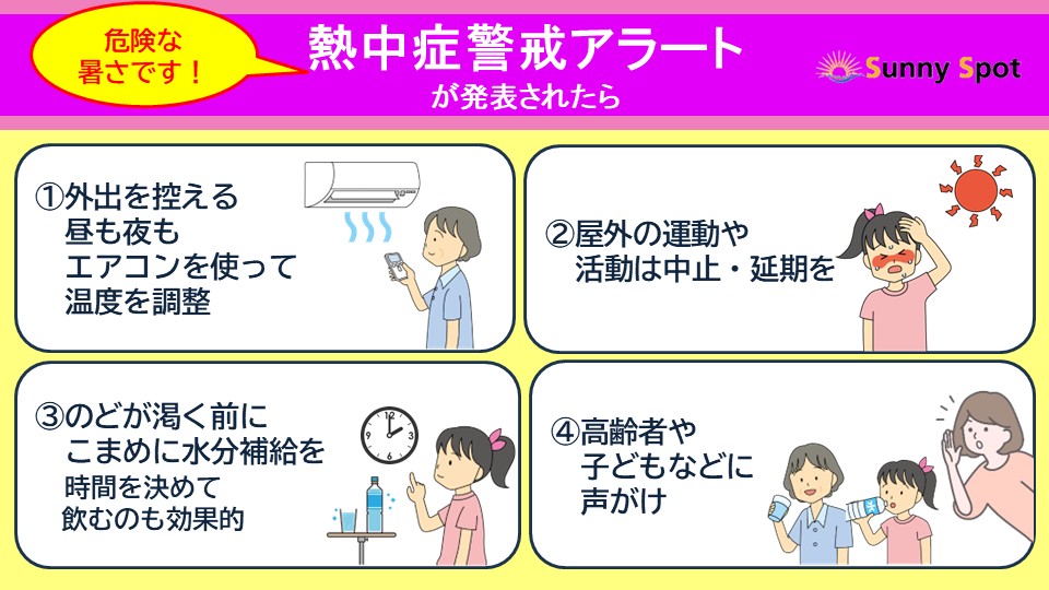
-
Typhoon No. 9: In Okinawa and Amami, watch out for high waves and strong winds even after the typhoon has left
2026/07/11 23:23

-
Large and strong Typhoon No. 9 is currently in the East China Sea, moving northwest at a speed of approximately 30 kilometers per hour.
Today, the 11th (Saturday), heavy rain of 45.0mm was observed in Shimojishima, Miyakojima City, Okinawa Prefecture, in the hour until 8:55, and the daily precipitation until 9:00pm today was 175.0mm.
The maximum instantaneous wind speed was 45.3 m/s in Kitahara, Kumejima Town, Shimajiri District, Okinawa Prefecture in the morning.
#Typhoon No.9 11th (Saturday) 21:00
==================
Size large
Strength strong
Movement North-northw
Center location East China Sea
Movement Northwest 30km/h
Central pressure 950hPa
Maximum wind speed 40m/s (near the center)
Maximum instantaneous wind speed 55m/s
========================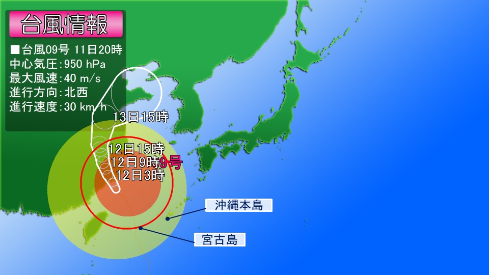
Typhoon No. 9 is expected to make landfall in central China tomorrow, the 12th (Sunday), and turn into an extratropical cyclone on the 15th (Wednesday).
In the Okinawa and Amami regions, the center of the typhoon is gradually moving away, but please continue to be wary of high waves accompanied by swells into tomorrow, the 12th (Sunday).
Also, even if the rain stops, the windy conditions are expected to continue. Please be careful of strong winds.
[Wave forecast]
Wave height expected for tomorrow, the 12th (Sunday)
Amami region 6 meters with swells
Okinawa region 9 meters with swells
[Wind forecast]
Maximum wind speed (maximum instantaneous wind speed) expected for tomorrow, the 12th (Sun)
Amami region 15 meters (25 meters)
Okinawa region 20 meters (30 meters)