


-
High temperatures continue; from "dry and hot" to "humid" next week
2024/05/17 16:18
-
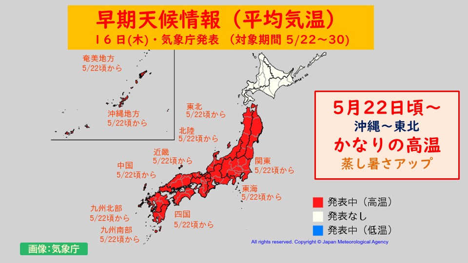
The Japan Meteorological Agency has released early weather information regarding high temperatures.
Up until now, early weather information regarding high temperatures has been announced several times, but
the previous "crisp heat" has changed,
next week will be even more "sultry and humid". The risk of heat stroke seems to be higher.
The cause of this hot and humid weather is the "front".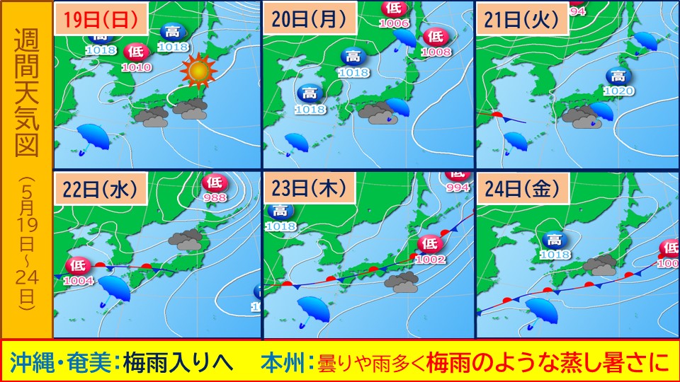
Next week is the front line is likely to move northward from the south and become stagnant on the Pacific side.
As you enter the south side of the front, warm, humid air flows in,
covering you with ``mushy'' air.
For this reason, the temperature and humidity will be high next week, so the risk of heatstroke will be even higher than
, and we will need to be careful.
It's a good idea to start taking measures to prevent the heat and humidity, such as wearing clothes that dry easily even when you sweat.
-
Saturday and Sunday: The hottest places of the season. Next week: The Honshu area will also be cloudy and rainy. Is it the rainy season
2024/05/17 14:29
-
Weather and temperature for tomorrow 18th (Saturday) and 19th (Sunday)
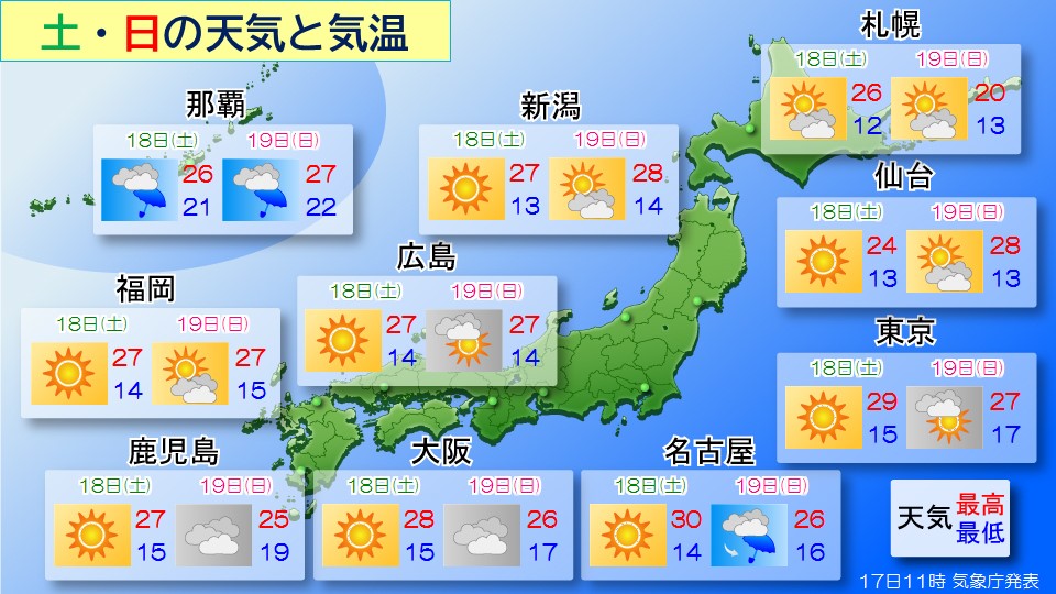 The sun and southerly winds will raise the temperature, making it likely to be the hottest season of the season in some places.
Tomorrow (Saturday), temperatures are expected to reach 30c in Nagoya, Kyoto, and Fukushima, and
Nagoya may experience the first midsummer day of 30c or higher this year.
Also, the temperature in Tokyo has reached 29 degrees Celsius, which is likely to be the hottest season this season.
Although it's a perfect day for going out and going on vacations in many places, it's still a time when people aren't used to the heat, so
take measures to prevent heat stroke, such as hydrating frequently and choosing a shaded area for walking.
Please make sure to do this properly.
The day after tomorrow (Sunday)
During the day, it is sunny and the sun is shining in many places.
The heat continues during the day, and Sendai is expected to be as hot as 28 degrees Celsius in late July.
Nagoya has an umbrella symbol,
As of now, it looks like there will be some places on the Pacific side of western and eastern Japan where it will rain starting at night.
If you are returning late on Sunday, it is a good idea to bring rain gear.
It's sunny today in Okinawa and the Amami region, but it will continue to rain from tomorrow onwards.
In Okinawa and Amami, there may be an announcement about the beginning of the rainy season during Saturday and Sunday.
(Rainy season starts in normal years Okinawa region: around May 10th, Amami region: around May 12th)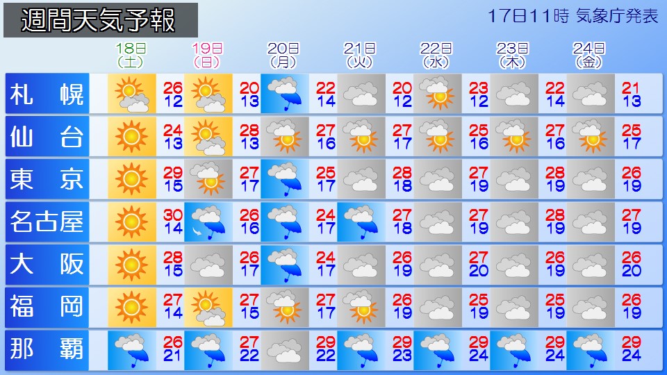
Next week, there will be damp air around the edge of the high pressure system,
the front will likely stay on the Pacific side of Honshu, and
it will be cloudy and rainy near Honshu. There will be many days of
The rainy season begins around May 30th in southern Kyushu, and
It looks like the rainy season will start early in the Honshu region.
It might be a good idea to take advantage of the sunshine this Saturday and Sunday,
and put away large laundry items such as futons and sheets.
-
Tohoku Sea of Japan side: Strong winds before noon, warning of high waves until midafternoon
2024/05/17 05:50
-
A developed low pressure system is located in the Sea of Japan and is moving northeast, and is expected to pass through northern Japan today, the 17th (Friday).
In addition, strong cold air with temperatures below -21 degrees Celsius (for this time of year) is flowing into the area around 5,500m above Tohoku, making the
atmospheric condition extremely unstable. .
*Wind and Wave Forecast
On the Sea of Japan side of the northeastern part of Japan, it is expected that the storm will blow westward until noon today, Friday the 17th, and become a major storm by the afternoon.
Today's expected maximum wind speed (maximum instantaneous wind speed)
Tohoku Sea of Japan side Sea 20 m/s (30 m/s)
Tohoku Sea of Japan side Land 18 m/s (30 m/s)
Tohoku Pacific side Sea: 18 m/s (30 m/s)
Tohoku Pacific side On land: 15 m/s (30 m/s)
Today's expected wave height
Tohoku Japan Sea side: 6 m
Tohoku Pacific side: 3 m
*Lightning Forecast
In the Tohoku region, the
atmospheric condition will become extremely unstable until the afternoon of Friday the 17th, resulting in the development of cumulonimbus clouds,
where lightning will occur. It is expected.
On the Sea of Japan side of northeastern Japan,
beware of strong winds from the west until before noon today,
and be wary of damage to ships and
coastal facilities from high waves until afternoon today.
Also, in the Tohoku region, please be careful of heavy gusts of wind such as tornadoes, lightning, hail, and
sudden heavy rain through the afternoon today.
If there are signs that a cumulonimbus cloud is approaching, please take precautions such as moving to a sturdy building.
-
Hokuriku: Warning of strong winds and high waves until noon
2024/05/17 05:50
-
There is a developed low pressure system in the central Japan Sea that is moving northeast and is expected to reach the vicinity of Hokkaido today, the 17th (Friday) morning.
As a result, very strong winds will blow mainly over the sea in the Hokuriku region until noon today, Friday the 17th,
, causing severe storms in some places.
In Ryotsu, Sado City, Niigata Prefecture, extremely strong winds with a maximum instantaneous wind speed of 32.3 m/s were observed at 2:03 AM today.
In the Hokuriku region, please be on guard for strong winds and high waves until noon today, Friday the 17th.
*Wind forecast
Today's expected maximum wind speed (maximum instantaneous wind speed)
Niigata prefecture land 20m/s (30m/s)
Niigata prefecture sea 20m/s (30m/s)
Toyama prefecture land 15m/s (30m/s)
Toyama prefecture sea 20m/s (30m/s)
Ishikawa prefecture land 12m/s (25m/s)
Ishikawa prefecture sea 18m/s (30m/s) )
Fukui prefecture land 6m/s
Fukui prefecture sea 10m/s (20m/s)
*Wave forecast
Today's expected wave height
Niigata prefecture 6m with swells
Toyama Prefecture 2.5m
Ishikawa Prefecture 5m with undulations
Fukui Prefecture 4m with undulations
-
[1-month forecast] High temperatures throughout the country in the second half of May... Rainy season with heavy rain from Okinawa to the Pacific side of western Japan
2024/05/16 19:20
-
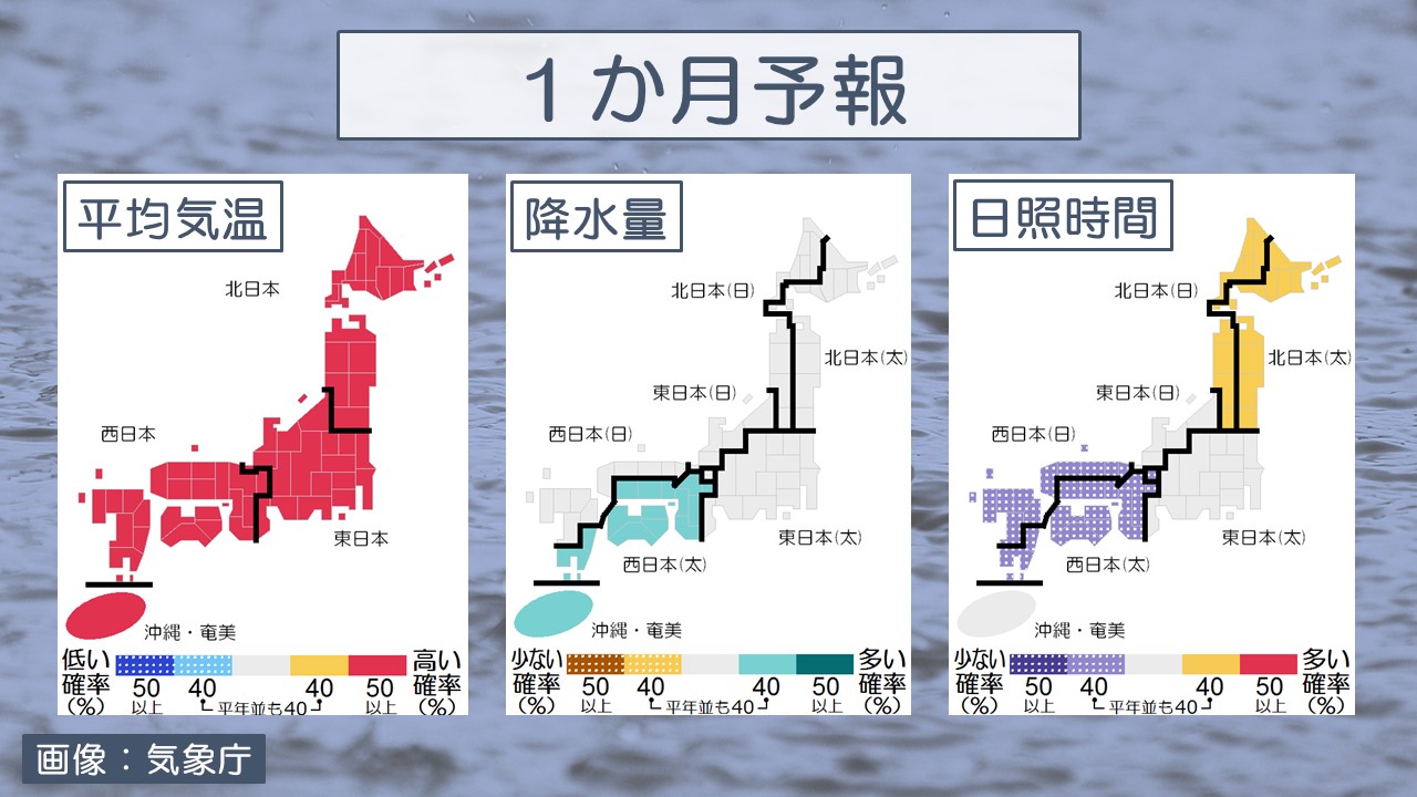
Today, the 16th (Thursday), the Japan Meteorological Agency announced a one-month forecast.
Weather outlook for the next month (5/18-6/17)
*Temperature
As warm air tends to flow in, temperatures will be high nationwide.
Temperatures are expected to be quite high, especially during the first half of the period.
*Precipitation
The Pacific side of western Japan and Okinawa/Amami have periods where they are susceptible to fronts and humid air, so precipitation will be at or above normal.
*Sunshine hours
In northern Japan, there are periods when it is easily covered by high pressure, so it will be at or above normal.
Western Japan is expected to be at or below normal.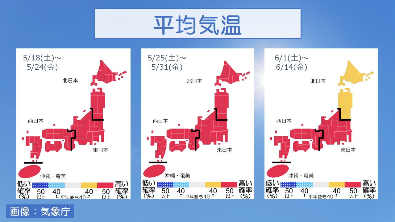
*Week 1 (5/18 to 5/24)
In northern Japan, the weather changes every few days, but
is easily covered by high pressure and has more sunny days than normal. .
On the Sea of Japan side of eastern Japan, the weather changes every few days.
On the Pacific side of eastern Japan and western Japan,
the weather changes on a cycle of several days, but they are susceptible to the influence of fronts and humid air,
with fewer sunny days compared to normal years.
Okinawa/Amami is easily affected by fronts and humid air,
with more cloudy and rainy days than normal.
*2nd week (5/25-5/31)
On the Sea of Japan side of northern and eastern Japan, the weather changes every few days.
On the Pacific side of eastern Japan and western Japan,
the weather changes on a cycle of several days, but they are susceptible to the influence of fronts and humid air,
with fewer sunny days compared to normal years.
Okinawa/Amami has many cloudy and rainy days, similar to normal years.
*Week 3 to 4 (6/1 to 6/14)
On the Sea of Japan side of northern and eastern Japan, the weather changes every few days.
The Pacific side of eastern Japan, western Japan, and Okinawa/Amami have many cloudy and rainy days, similar to normal years.
-
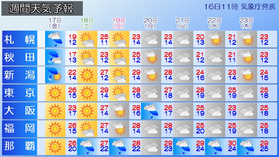
Weather for the week: The weather is unseasonably hot in some places on the weekend, but the weather is gradually going downhill.
2024/05/16 16:56
-
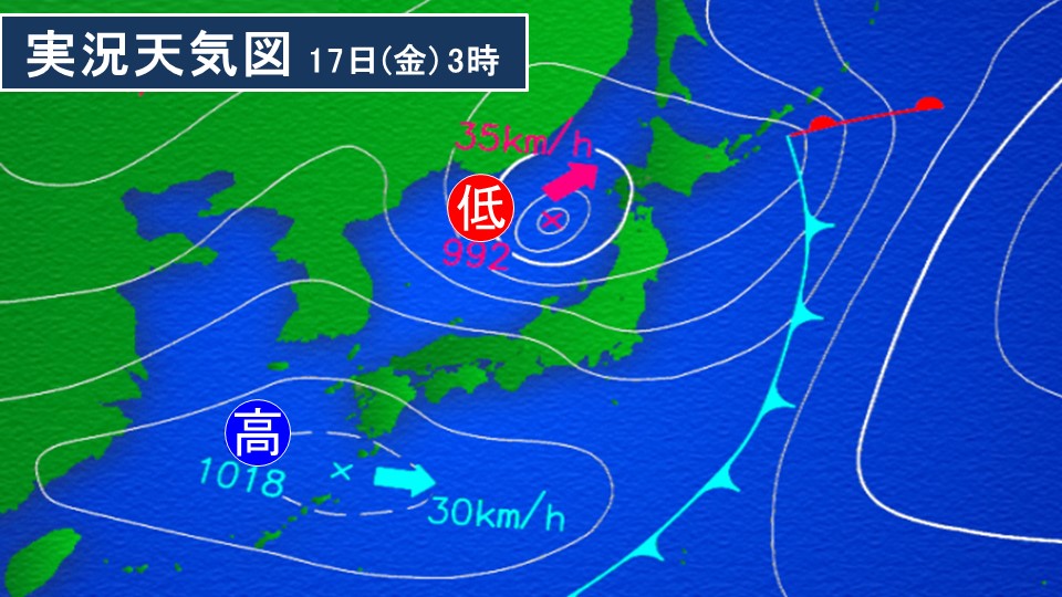
Tomorrow, the 17th (Friday), a low pressure system accompanied by cold air will pass through northern Japan.
Due to the influence of cold air in the upper atmosphere and moist air moving towards a low pressure system, there is a risk that the atmospheric conditions will become extremely unstable, mainly on the Sea of Japan side of northern Japan.
Be careful of thunderstorms, tornadoes, strong gusts of wind, and sudden heavy rain. If black clouds approach, the sky suddenly turns dark, and cold winds start blowing, be sure to stay safe by moving to a building.
Also, please be wary of strong winds, especially on the Sea of Japan side of northern Japan.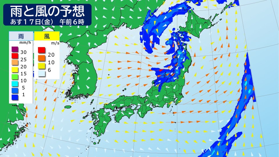
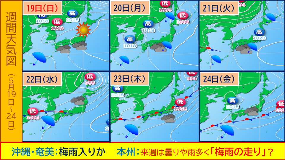
Tomorrow is the 18th (Saturday), the front that has been stationary in the south of Japan will move north.
There are times when it rains in Okinawa and Amami, and from Saturday the 18th onwards, the weather will continue to be cloudy and rainy, and there may be an announcement that the rainy season will start.
The developed low pressure system is moving away from Japan, and the weather is improving in northern Japan.
It will be sunny from western to northern Japan.
The maximum daytime temperature is expected to be 30c in Nagoya, Gifu, Kofu, and Kumagaya, 31c in Fukushima, and 25c in Sapporo.
When spending a long time outdoors, such as during a sports day, be careful of heat stroke.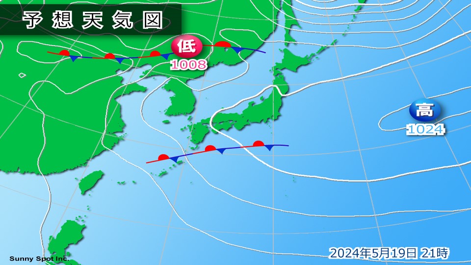
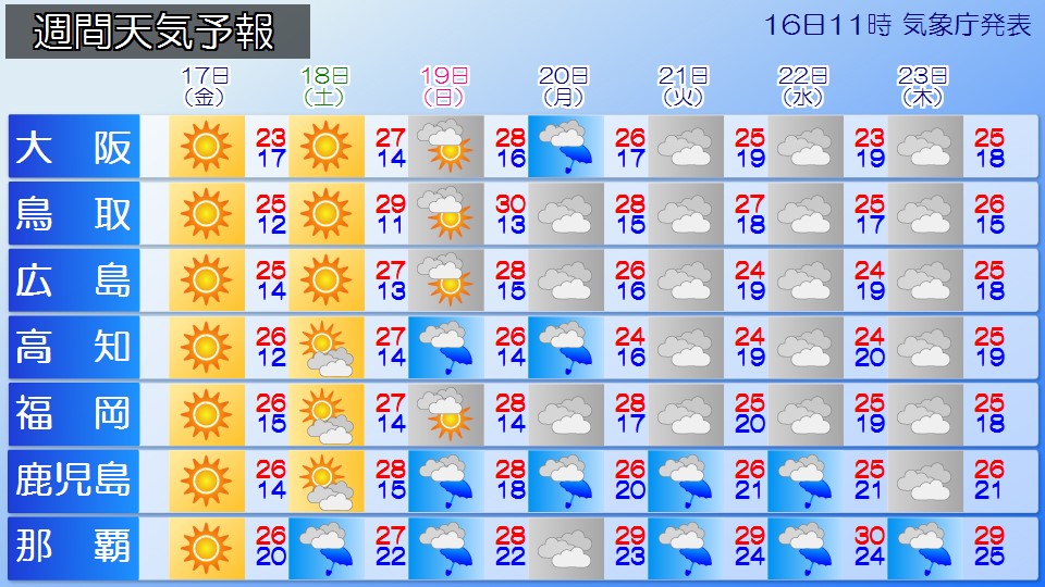
19th (Sun) ), the front will move further north, extending from the East China Sea to the southern coast of western Japan.
In western Japan, clouds tend to spread mainly on the Pacific side, and rain is expected to occur in Kyushu and Shikoku.
The sun will shine through the gaps in the clouds in the Tokai region.
It is expected to be sunny north of Kanto.
The maximum daytime temperature will be high even in western Japan, where clouds tend to spread, reaching 31c in Kyoto.
It is expected that there will be midsummer days in some parts of the Kanto-Koshin region, mainly in the inland areas.
In northern Japan, with the addition of the Fohn phenomenon, Yamagata will experience unseasonably warm temperatures of 33 degrees Celsius, comparable to early August.
Please be careful of heat stroke even indoors due to the unfamiliar heat. Please remind elderly people and children who are sensitive to heat to stay hydrated frequently.
From the beginning of next week, western and eastern Japan will be covered in clouds due to the northward movement of the front.
It is expected to rain in some places, mainly on the Pacific side.
Depending on the movement of the front, you may be more susceptible to the effects of warm, humid air, and cloudy forecasts may change to rain or heavy rain, so please keep an eye on the latest weather information.
Northern Japan is susceptible to the effects of low pressure and clouds tend to spread, but there are places where the sunlight can reach through the gaps in the clouds.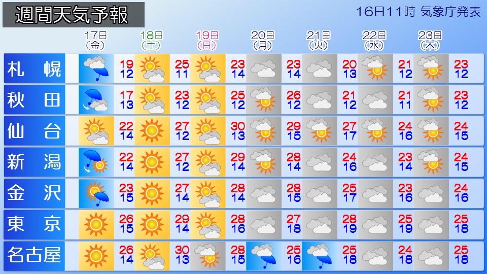
-
A large swirling cloud over the Sea of ??Japan. The effects of the cold vortex are lingering. There are places with strong winds like a typhoon by tomorrow.
2024/05/16 12:42
-
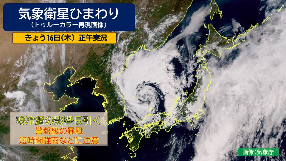
Looking at the meteorological satellite Himawari as of noon today, Thursday the 16th (title image)
There is a large swirling cloud over the Sea of Japan.
This is a cloud associated with a low pressure system (cold vortex) accompanied by cold air.
The cold vortex is moving northeast across the Sea of Japan while developing.
The atmospheric conditions around Honshu are extremely unstable due to the influence of cold air in the upper atmosphere and warm, humid air flowing toward the cold vortex.
There are some places where the rain is particularly strong, especially in the San'in region and Hokuriku region, which are close to the cold vortex.
In addition, the wind from the west is increasing in western Japan,
by noon today, the maximum instantaneous wind speed was 26.2m/s in Kimotsuki-cho, Kagoshima Prefecture,
25.7m/s in Takamatsu-shi, Kagawa Prefecture. ,
both recorded the strongest winds on record for May.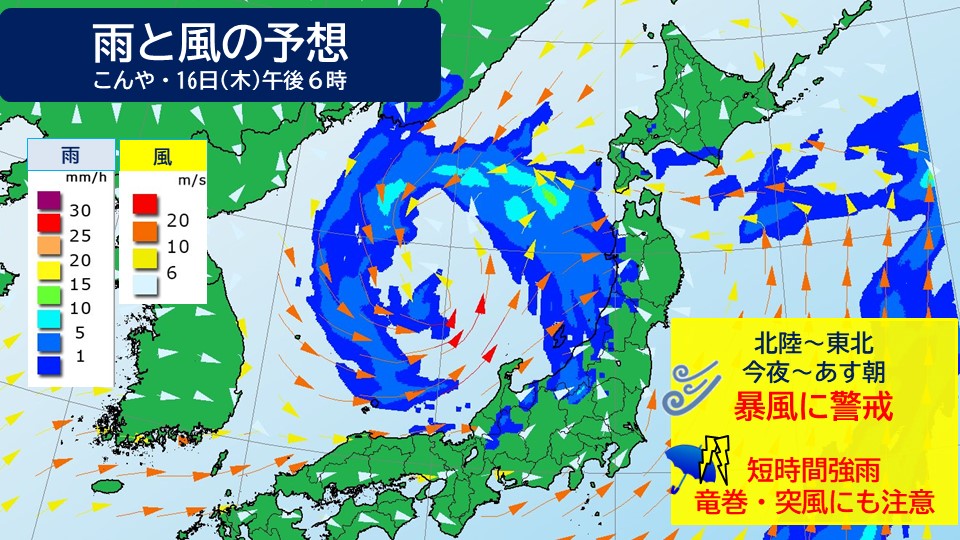
# The movement of the cold vortex is slow and its effects will last
The movement of the cold vortex is relatively slow and the rough weather is expected to continue mainly on the Sea of Japan side until tomorrow, the 17th (Friday).
In the Sea of Japan side of Hokuriku and Tohoku, strong winds are expected to blow from the west starting tonight, and
there is a risk of strong winds reaching warning level until tomorrow.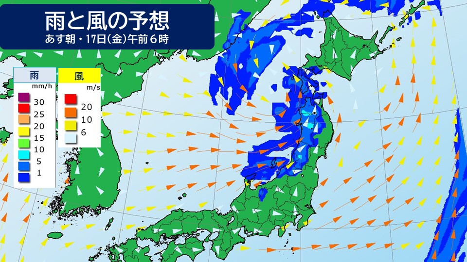
Tomorrow, The maximum instantaneous wind speed expected in the Hokuriku and Tohoku regions is
25-30m/s, which is extremely strong enough to overturn a truck.
In particular, from tonight to tomorrow morning, strong winds comparable to a typhoon are expected to blow, which may affect
transportation such as trains, expressways, and airplanes along the coast.
Please check the latest weather and traffic information before heading out.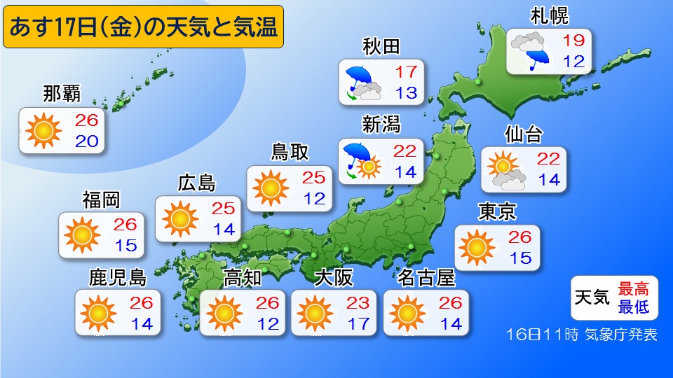
Tomorrow, Western Japan On the Pacific side of eastern Japan,
the cold air will disappear and it will gradually be covered by high pressure, so
it will be stable and sunny in many places.
However, even if the weather improves, there will still be some places where the westerly wind will blow strongly in the morning.
-
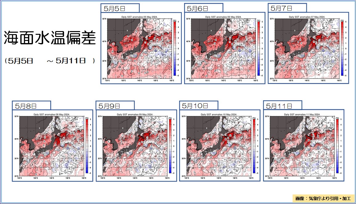
The Kuroshio Current meander, the longest in recorded history, sea surface temperature off the coast of Sanriku is up to 7c higher (May 5th to May 11th, 2024 Ocean Summary)
2024/05/16 11:04
-
It has been 6 years and 10 months since the Kuroshio Meander began, making it the longest period on record.
Ocean Summary May 5th to May 11th, 2024.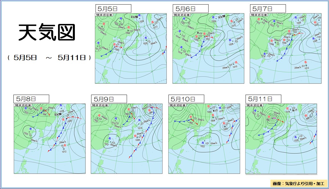
#Barometric pressure distribution On the 5th, a high pressure system covered Honshu from the east of Japan.
Wave height is 3m in the East China Sea and south of Japan, where southerly winds prevail on the edge of the anticyclone.
From the 6th to the 7th, a low pressure system accompanied by a front passed from the Sea of Japan to Hokkaido.
From the night of the 6th to the 7th, wave heights were 4 to 5 meters mainly in the northern Sea of Japan.
On the 8th, a front passes to the east of Japan, and a high pressure system overhangs the continent.
Japanese waters started to rise, but the waves subsided by night.
From the 9th to the 10th, the area around Honshu was within the area of high pressure.
On the 9th, waves rose to 2-3 meters in height in the eastern Kanto region, but remained calm on the 10th.
On the 11th, a low pressure system accompanied by a front moved eastward over the continent.
The southwest wind towards the low pressure system has strengthened, and wave heights of 2 to 3 meters are widespread in the Japanese waters at night.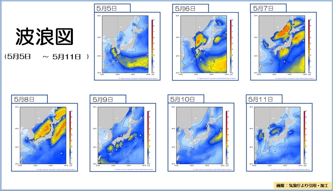
#Sea surface temperature
Towards the end of this period, areas in the Japanese sea area where sea surface temperatures were at or slightly above normal expanded.
In the East China Sea and the Nansei Islands, areas of sea area that are at normal levels are expanding.
On the Pacific side, the Kuroshio Current continues to meander, and conditions continue to be slightly lower than normal off Cape Shiono, where the Kuroshio Current leaves the shore.
The waters off the coast of Sanriku, where the Kuroshio Current moves northward, continued to be much warmer than normal, with temperatures up to 7 degrees Celsius.
The temperature off the southeastern coast of Hokkaido, where the Oyashio Current is receding, was also significantly higher than normal, with temperatures up to 6 C higher.
The Sea of Okhotsk and the waters around the Kuril Islands continued to be at normal levels.
-
Strong cold air is flowing in, making the atmosphere unstable. Be careful of lightning strikes and gusts of wind.
2024/05/16 07:22

-
From tomorrow, the 17th, extremely cold air for this time of year is expected to flow approximately 5,500 meters above western Japan to northern Japan, with temperatures below -21 degrees Celsius. Also, today, the 16th, a developing low pressure system will move northeast across the Sea of Japan, and tomorrow, the 17th, it will pass through northern Japan. Due to the effects of cold air in the upper atmosphere and moist air flowing toward low pressure, atmospheric conditions are expected to be extremely unstable in western Japan today, the 16th, and from today's 16th to tomorrow 17th in eastern and northern Japan.
#Disaster prevention matters
Be careful of lightning, tornadoes, strong gusts of wind, and sudden heavy rain from western Japan to northern Japan. If there are signs that a cumulonimbus cloud is approaching, please take precautions such as moving inside a building. There is also a risk of hail, so please be careful when managing crops and agricultural facilities.
-
Today's weather: Atmospheric conditions are unstable mainly on the Sea of ??Japan side. Be careful of sudden changes in the weather.
2024/05/16 06:56

-
Today, the 16th, a low pressure system with strong cold air in the sky is expected to move northeastward across the Sea of Japan. Atmospheric conditions are unstable, especially on the Sea of Japan side, and caution should be taken in case of sudden changes in weather.
Strong in the sky A low pressure system accompanied by cold air moves northeast across the Sea of Japan. Cold air below -21c will flow approximately 5,500 meters above Japan, resulting in unstable atmospheric conditions mainly on the Sea of Japan side of western and eastern Japan. Please be careful as rain clouds may develop suddenly and may be accompanied by lightning, gusts of wind, and hail.
There will be showers in the Kanto and Tokai regions, mainly in the morning.
The weather seems to be heading towards recovery in the afternoon.
It will start to rain in some places in Tohoku and Hokkaido at night.
If you are returning late, please bring rain gear.
As cold air moves southward, temperatures are likely to drop in many places, especially in western Japan, compared to the previous day. Please be careful when choosing your clothes.