


-
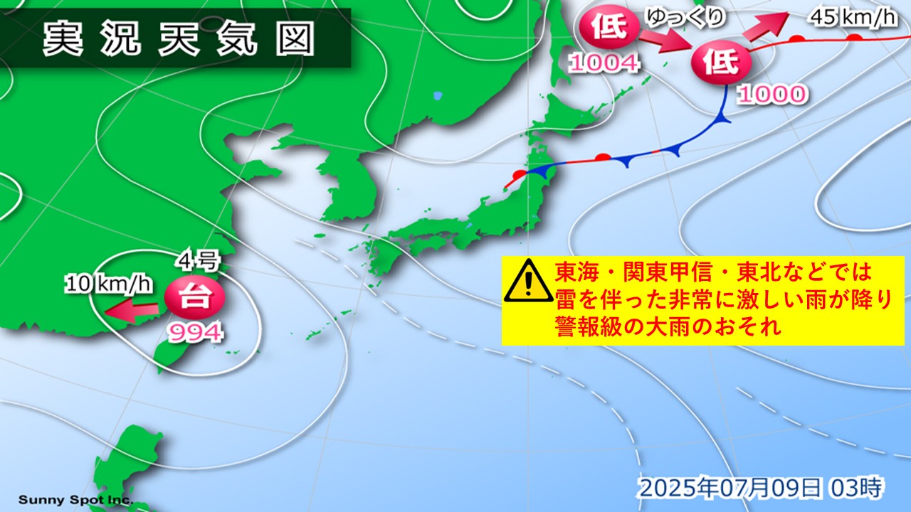
Typhoons are expected to occur in the waters near Ogasawara within 24 hours; it is expected to travel north over Japan's Tokai region in the future.
2025/07/11 17:50

-
Today, the 11th (Friday), a tropical cyclone broke out in the waters near Ogasawara. This tropical cyclone is expected to develop into a typhoon within the next 24 hours. If it were to become a typhoon, it would be called Typhoon No. 5.
#Tropical cyclone: Friday the 11th, 3pm
===
Center location: Ogasawara waters
Moving speed: West-northwest, slow
Center pressure: 1002hPa
Maximum wind speed: 15m/s (near the center)
Maximum instantaneous wind speed: 23m/s
===
/Based on today, the 11th, the tropical cyclone will become a typhoon in the waters near the Ogasawara Islands by tomorrow, Saturday the 12th, and will then move northward over Japan's Tokai region with a speed increase. It is expected to turn into a temperate cyclone in the waters near the Kuril Islands on Tuesday the 15th.
In Ogasawara, the rain and wind will gradually increase as Sunday the 13th, and waves will rise at sea with swells. Be careful of intensifying rain, strong winds and high waves.
In Kanto, Tohoku, and Hokkaido, rain and wind will increase, mainly in the coastal areas from the 14th to the 15th due to the effects of typhoons moving north. Additionally, as another low pressure system is expected to move eastward from the East China Sea around Japan, rain and wind will increase nationwide, and there is a possibility that heavy warning-level rain will occur, especially in the Pacific side of western Japan and eastern Japan.
Please be careful of the latest weather information that will be updated in the future.
-
Next week, the stormy weather in Kanto and Northern Japan will affect transportation, and there are fears of heavy rain on the alert
2025/07/11 13:05

-
#Scary weather in Kanto and Northern Japan next week Will transportation be affected There may be fears of heavy rain on the warning level
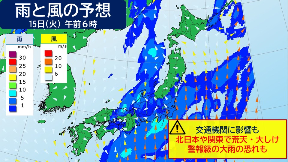
On Monday the 14th, a low pressure system will move around western Japan.
It is expected that there will be some areas in the East, Western Japan and the Nansei Islands.
Towards the 15th (Tuesday), warm, moist air, tropical air, will flow towards the low pressure system, causing heavy rain, localized, mainly on the Pacific side.
There is a risk of heavy rain at the warning level, especially in the southern Kanto region, where warm and humid air is prone to flowing into the air.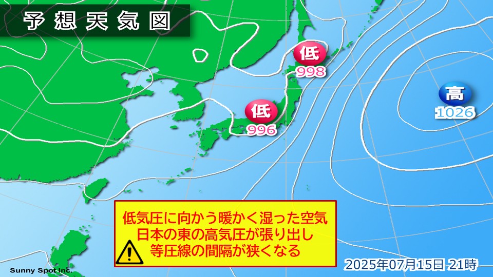
Also, towards the second half of the week, high pressure in the eastern part of Japan will increase and spread out near Japan.
The pressure slope will increase on the Pacific side of the north and eastern Japan, mainly from Tuesday the 15th to Wednesday the 16th, and the wind from the south will increase, causing rough weather and heavy damage.
Please be careful of the latest weather information as it may affect transportation.
-
Next week, the stormy weather in Kanto and Northern Japan will affect transportation, and there are fears of heavy rain on the alert
2025/07/11 12:49
-
#Scary weather in Kanto and Northern Japan next week Will transportation be affected There may be fears of heavy rain on the warning level
On Monday the 14th, a low pressure system will move around western Japan.
It is expected that there will be some areas in the East, Western Japan and the Nansei Islands.
Towards the 15th (Tuesday), warm, moist air, tropical air, will flow towards the low pressure system, causing heavy rain, localized, mainly on the Pacific side.
There is a risk of heavy rain at the warning level, especially in the southern Kanto region, where warm and humid air is prone to flowing into the air.
Also, towards the second half of the week, high pressure in the eastern part of Japan will increase and spread out near Japan.
The pressure slope will increase on the Pacific side of the north and eastern Japan, mainly from Tuesday the 15th to Wednesday the 16th, and the wind from the south will increase, causing rough weather and heavy damage.
Please be careful of the latest weather information as it may affect transportation.
-
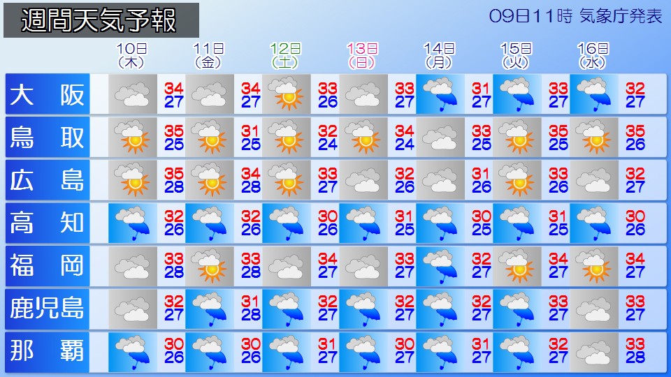
The heat is alleviating in the Kanto region; Western Japan continues to heatstroke alert alert alert for Ishikawa, Wakayama and Fukuoka
2025/07/11 10:09

-
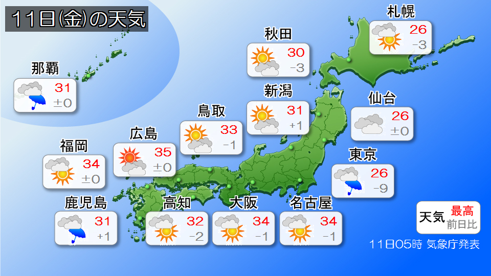
Today, the 11th, the cold eastward wind blowing from the high pressure of the Sea of Okhotsk, temperatures will be modest, especially in the Pacific side of northern Japan and the Kanto region.
The estimated maximum temperature in central Tokyo is 26c, 10c lower than yesterday (7th), when it was a hot day. In central Tokyo, the temperature has been in the 20 C for the first time in about two weeks since June 25th, so it will feel a little easier to spend than before.
Although clouds are likely to spread in Tokai to Western Japan, the heat is expected to continue. In addition, some places may be midsummer days on the Sea of Japan side of Tohoku and Hokuriku, where sunlight is reaching.
The forecast maximum temperatures are 33 C for Kanazawa, 34 C for Nagoya, 34 C for Osaka, 34 C for Kochi, 32 C for Fukuoka.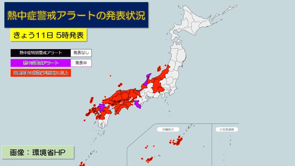
The Ministry of the Environment and the Japan Meteorological Agency have issued heatstroke warning alerts to Ishikawa, Wakayama, and Fukuoka prefectures.
In areas where a heatstroke warning alert has been issued, significantly higher temperatures can cause damage to human health due to heatstroke.
Please refrain from activities during the hot days as much as possible, and be careful to take frequent breaks, drink water and salt.
Also, make sure to stay in a cool environment, such as using air conditioners indoors, and take full advantage of heatstroke prevention indoors.
-
Weather today, Friday the 11th: The sky is dominant in the Kanto region; rain is mainly on the Pacific side in western Japan
2025/07/11 06:23

-
Today, the 11th (Friday), the rainy season front is expected to travel south to the Izu Islands, and the low-pressure area is expected to travel north through the East China Sea.
Hokkaido has a sky pattern where clouds are likely to spread out, but the sun will occasionally arrive.
Clouds tend to spread out on the Pacific Ocean side of Tohoku and Kanto, and the sky is unclear. There are areas where showers are present, so it's safe to have a folding umbrella when going out. On the other hand, the Sea of Japan side of Tohoku and Hokuriku are likely to have strong sunlight.
In Kanto, clouds are likely to spread easily, and the sky will continue to be unclear. It's safe to have a folding umbrella when going out.
Since cold air flows in, you need to be careful about the difference in temperature and yesterday.
Clouds will spread across Tokai, but there will be some time for the sun to reach it. In the afternoon, there are some showers, mainly inland areas and along the mountains, so be careful of changes in the sky.
In western Japan, west air flows through low-pressure areas, making it easy to rain, mainly on the Pacific side. Even if it's not raining when you're out, it's safe to bring a folding umbrella or something.
There is a risk of heavy rain and thunderstorms in southern Kyushu, Okinawa and Amami, so be careful of landslides, flooding of low lands, and rising rivers.
-
[Kanto Linear Precipitation Zone Predictions] Heavy rain peaks overlapping when you get home today; the risk of disasters increases rapidly; Protect yourself from torrential rain
2025/07/10 11:44

-
The Japan Meteorological Agency announced before 10am today (Thursday), 10th, "Linear precipitation zones will occur in Ibaraki Prefecture, Tochigi Prefecture, Gunma Prefecture, Saitama Prefecture, Chiba Prefecture, and Tokyo regions from the evening until the beginning of the evening today, Thursday, 10th, and the risk of heavy rain disasters may increase dramatically."
The rainy season front will revive today, Thursday the 10th, and the
front will travel south from the Tohoku region to the Kanto region tomorrow, Friday the 11th.
With the influence of warm, humid air towards the front, rising daytime temperatures and cold air above, the air condition of the
/b is expected to become extremely unstable over a wide area in the Kanto region, especially from the evening.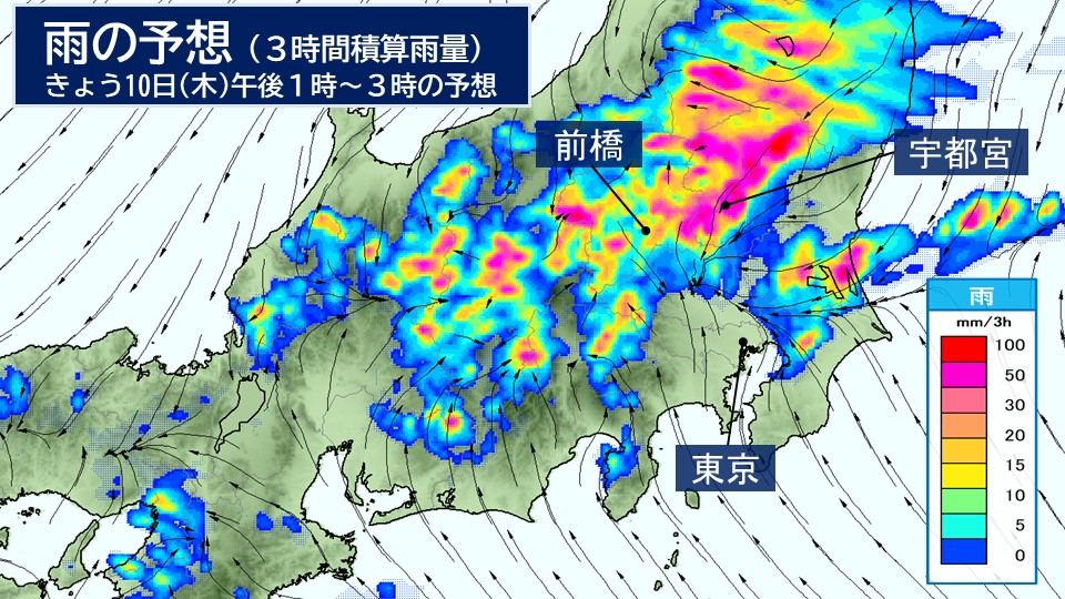
If you look at the forecast for the rain and wind starting today, the 10th (Thursday), we will see a prediction that
/active rain clouds will appear in red from southern Tohoku to northern Kanto.
Under these rain clouds, nearly 100mm of rain falls in three hours, and
Heavy rain falls all at once in a short period of time,
The risk of heavy rain disasters increases dramatically.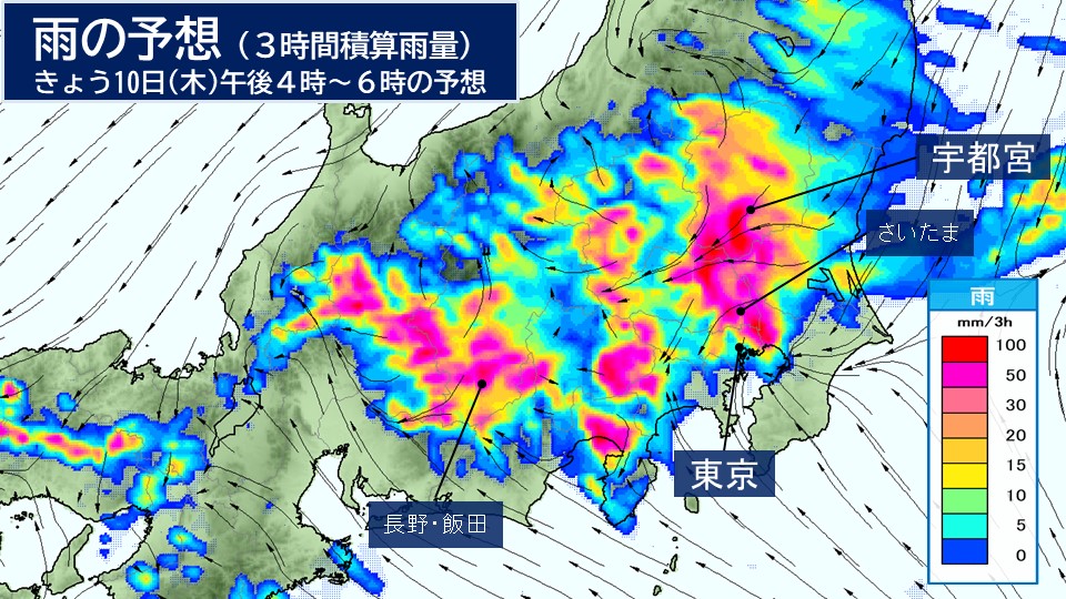
In addition, in the evening, active rain clouds also hit the southern Kanto region, and in central Tokyo, it seems that heavy rain will reach the peak of heavy rain when you get home.
There are places where extremely heavy rain of over 50mm per hour with lightning, and
There is a risk that roads will become like rivers, exceeding the drainage function of urban areas.
If the rain clouds move slowly or stagnate, a linear precipitation zone will occur, and torrential rain may occur.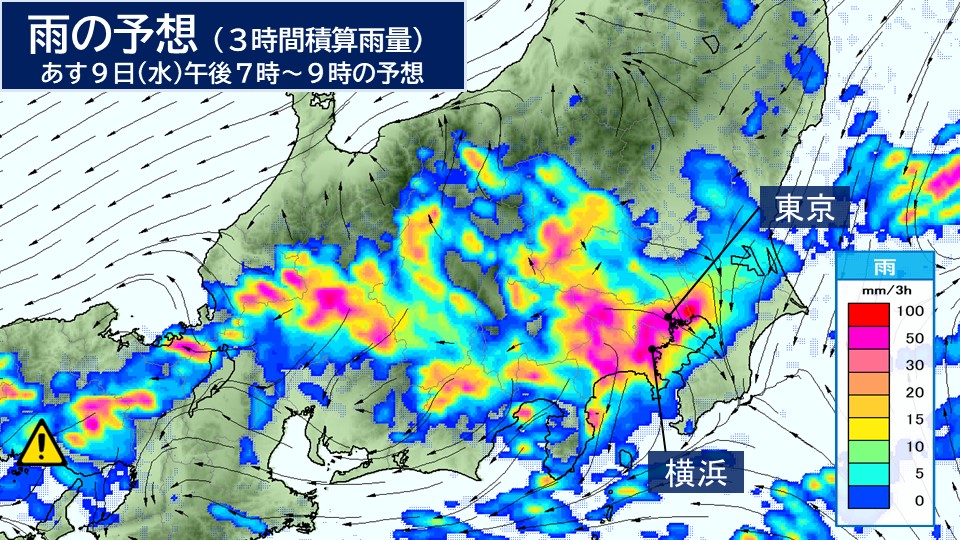
At night, there will be fewer heavy rains in the north Kanto region, but in southern Kanto region, such as Tokyo and Yokohama, heavy rain is expected to continue, with some areas becoming rainy.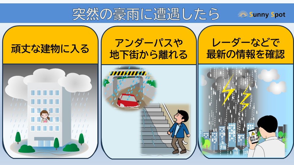
Check out the surrounding rain clouds frequently using the rain cloud radar today.
If heavy rain begins, please stay away from underpasses and underground facilities and on the second floor or above of a sturdy building.
/ Also, try to stay away from the mountains, cliffs and slopes even within your home.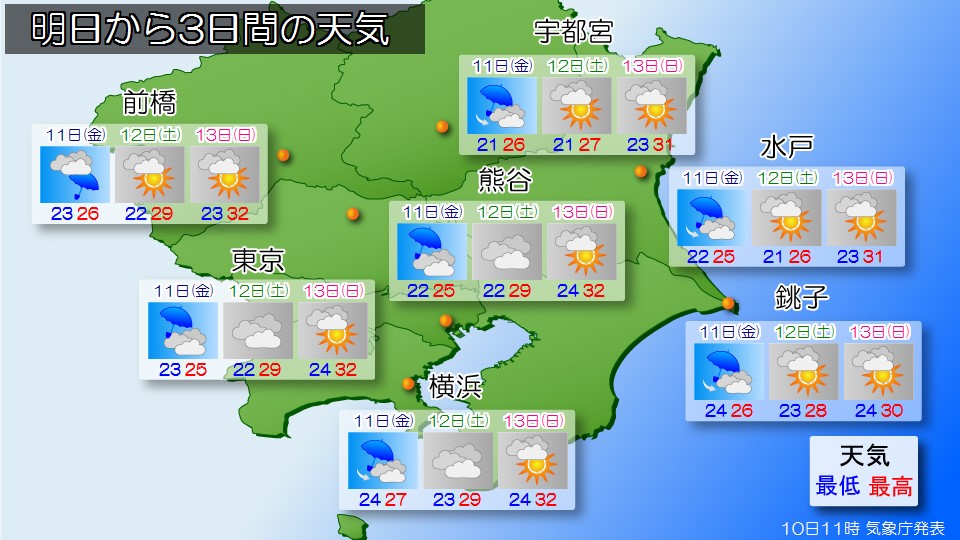
The atmosphere is expected to continue to remain unstable tomorrow, the 11th (Friday), and
Rain is expected to continue to be prone to falling.
However, tomorrow will turn into a north wind, and the temperature will not rise
Tomorrow's highest expected temperature in Tokyo is 25c, which is likely to be quite cool.
Please be careful of changes in temperature.
-
Atmospheric unstable. From Tohoku to Kanto, from southern Kyushu to Okinawa, from Okinawa to heavy rain.
2025/07/10 08:44

-
The rainy season front extends from Japan's Tokai to the Tohoku region.
In addition, there are low pressure systems in the south of Japan and around the Sakishima Islands, moving north-northwest and north-east respectively.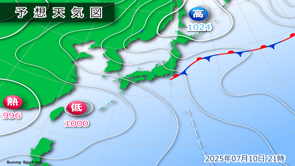
The rainy season front is expected to travel south through the Tohoku and Kanto-Koshin regions from Thursday the 10th to tomorrow, Friday the 11th.
In the Tohoku region and eastern Japan, the air condition will likely be extremely unstable today, the 10th (Thursday), due to the influence of warm, humid air flowing towards the front, rising daytime temperatures, and cold air above.
In addition, in western Japan and the Nansei Islands, the air condition is expected to become extremely unstable today, the 10th (Thursday), due to the effects of warm, humid air flowing around the edge of high pressure and rising daytime temperatures.
In the Kanto-Koshin region, on the 10th, beware of low-lying flooding, river flooding and overflowing, and landslides, and beware of the Tohoku region, western Japan and the Nansei Islands.
Also, be careful of severe gusts of wind, such as lightning strikes and tornadoes, and hail fall.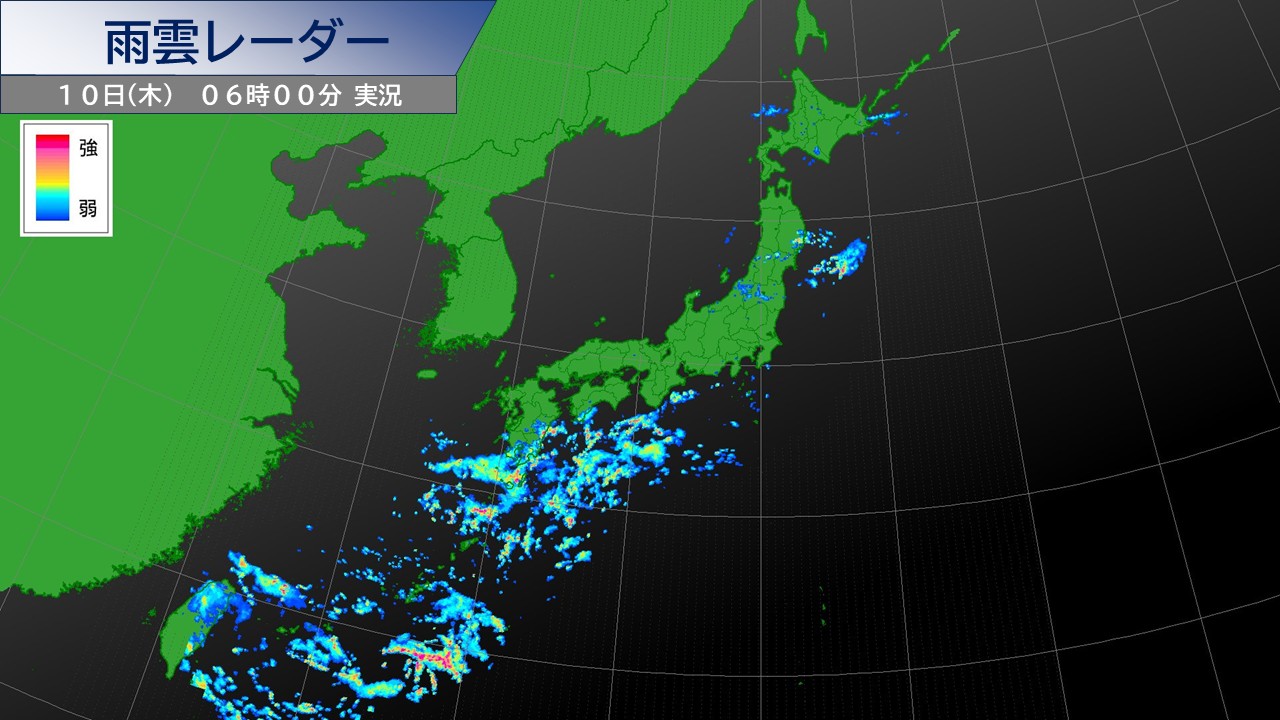
[Rain commentary]
Precency from the start of falling (00:00 on the 8th) to 5:00 on the 10th (preliminary figures from Amedas)
Okinawa Main Island Region
src="https://www.sunny-spot.net/topics/20250710084209_4.jpg" alt="image" width="720" align="center">
[Rain forecast]
From the Tohoku region to the western Japan and the Nansei Islands, there are likely to be some areas where extremely heavy rain and heavy rain accompanied by thunder will fall on the 10th.
The expected 1 hour precipitation on the 10th is high,
: Tohoku Sea of Japan side: 40mm
: Tohoku Pacific side: 40mm
: Northern Kanto region: 60mm
: Southern Kanto region: 50mm
: Koshin region: 50mm
: Miyazaki prefecture: 40mm
: Kagoshima prefecture (excluding Amami region): 40mm
: Amami Beauty region: 40mm
Okinawa main island region: 40mm
Sakishima Islands: 40mm
/B: The expected 1 hour precipitation on the 11th is high,
: Koshin region: 30mm
/Miyazaki prefecture: 40mm
/Kagoshima prefecture (excluding Amami region): 40mm
/B: Amami region: 40mm
The 24-hour precipitation expected from 6:00 on the 10th to 6:00 on the 11th is a high place:
Tohoku region Sea of Japan side: 60 mm
Tohoku region Pacific side: 60 mm
Kanto region Northern region: 120 mm
Kanto region Southern region: 100 mm
Koshin region: 120 mm
Miyazaki prefecture: 150 mm
Kagoshima Prefecture (excluding Amami) 120mm
Amami region 120mm
Okinawa Main Island Region 100mm
Sakishima Islands 80mm
[Disaster Prevention Items]
In the Kanto-Koshin region, be careful of low-reaching land flooding, river flooding and flooding, and landslides on the 10th, and be careful and wary of the Tohoku region, western Japan and the Nansei Islands.
Also be careful of severe gusts of wind, such as lightning strikes and tornadoes.
If there are signs of developing cumulonimbus clouds approaching, try to ensure safety by moving inside the building.
There is a risk of hail falling, so please be careful when managing agricultural crops and agricultural facilities.
-
Rainy season front revival, heavy rain in Kanto/Tohoku warning, how long will the heat last every day A new tropical cyclone emergence
2025/07/09 12:09

-
#Rainy season front revives warning-level heavy rain in Tohoku and Kanto Koshin
#Even though the heat of every day is coming to an end, western Japan continues to have a difficult night
#New tropical cyclone emerges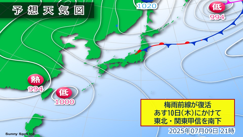
#Rainy season front revives warning-level heavy rain in Tohoku and Kanto Koshin
Today, Wednesday the 9th, a temperate cyclone from former Typhoon No. 3 is moving eastward east of the Kuril Island, and the front extends from this cyclone to Tohoku.
The rainy season front has been revived on the weather map.
This revived rainy season front is expected to travel south from Tohoku to Kanto Koshin until tomorrow, the 10th (Thursday).
The warm, humid air heading towards the front and rising daytime temperatures will make the air condition very unstable.
In Tokyo, rain clouds will develop locally in western Tama today, Wednesday the 9th, and tomorrow, Thursday the 10th, rain clouds will develop over a wide area of Tokyo, and there will be areas where heavy rain will fall with thunder in the afternoon.
Today, Wednesday the 9th, there will be extremely heavy rain, mainly in Tohoku, northern Kanto and Koshin, and tomorrow, the 10th, with locally heavy rain, like a waterfall with thunder, mainly in Kanto and Koshin.
If the rain clouds develop more or stagnate than expected, there is a risk of heavy rain at the warning level in Tohoku and Kanto Koshin.
Please be careful and be careful of landslides, flooding in lowlands, and rising rivers.
Even in plains such as around city centers, you need to be careful of road flooding.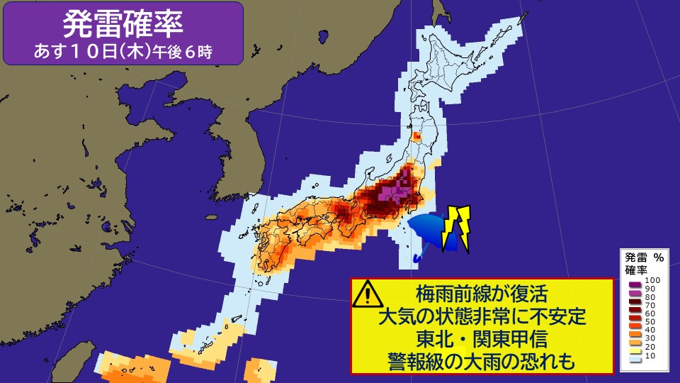
#Even though the extreme heat of the days will be over, western Japan will continue to have a difficult night in sleepy
From now on, the high pressure system in the Sea of Okhotsk will move south.
Also, as the rainy season front moves south, the overhang of the Pacific high pressure area around Japan is expected to weaken.
From tomorrow, the 10th (Thursday), many areas have been cloudy and unclear weather, and the harsh heat of every day has come to an end.
In the last few days, there have been some areas where the heat has exceeded their body temperature, but it is expected that the days will decrease when the hottest days are extremely hot with a maximum temperature of 35 C or higher.
In the city center, the highest temperature is expected to be 28 C on Friday the 11th, and there will be days when Northern Japan and Kanto will fall below 30 C.
It looks like the weather will finally be rainy season in Tohoku and Kanto Koshin.
However, there are probably many days when the temperature is higher than normal.
In western Japan, the lowest temperature is expected to last over 25 C, and even though the daytime heat has subsided, it is likely to continue on difficult nights.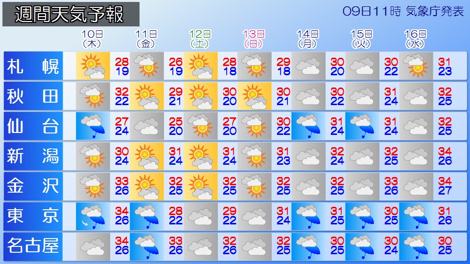
#Towards a new tropical cyclone
Today, Wednesday the 9th, at 9am, Typhoon No. 4 transformed into a tropical cyclone in South China.
However, a new tropical cyclone is expected to emerge around the Sakishima Islands around the 11th (Friday).
After that, you will head north from the Sakishima Islands around the East China Sea.
Please be careful of sudden, severe thunderstorms, lightning strikes and gusts of wind due to the persistent atmospheric unstable conditions in the Nansei Islands.
-
Revival of the rainy season front: Warning against heavy rain from the East to Northern Japan on the 9th
2025/07/09 05:56

-
As of the 9th (Wednesday), a front is occurring from Tohoku to the east of the Kurishima Islands. This front line is linked to Typhoon No. 3, which recently occurred.
Typhoon No. 3, which occurred in the waters near Ogasawara in the early hours of the 3rd, headed northeasterly in Japan and turned into a temperate cyclone in the east of Japan at 9am on the 8th. The unusual temperate cyclone is scheduled to integrate with the current front and move northeasterly east of the Kuril Island.
And the front that stretches from this low pressure system is the "revived rainy season front."
This rainy season front extends to the Tohoku region as of 3am on the 9th (Wednesday). In the future, this rainy season front is expected to travel south from east to northern Japan from Wednesday the 9th to Thursday the 10th.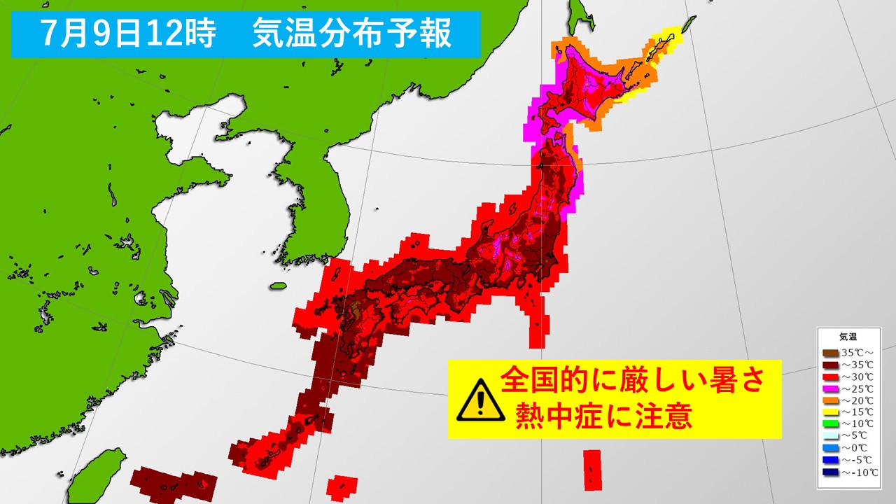
In addition, due to the Pacific High Pressure, Wednesday the 9th will be a midsummer day nationwide, and some are expected to be extremely hot.
This rise in temperature and the effects of lower warming and humidity flowing into the rainy season front will make the atmosphere very unstable.
As a result, in Tokai, Kanto, Koshin, Tohoku, and other places, extremely heavy rain with thunder, which could result in heavy warning-level rain.
Please be careful of landslides, flooding low land, flooding of rivers, lightning strikes, gusts of wind, and hail falls from the 10th to the 10th in northern Japan from the 9th (Wednesday) to the 10th (Thursday). . Locally, you need to be careful of severe gusts of winds such as tornadoes.
-
The highest temperature this year has been updated in central Tokyo; the number of hot and hot spots is over 160
2025/07/08 19:02

-
Today, the 8th (Tuesday), the area around Honshu was covered with high pressure, and the weather was sunny and severe heat.
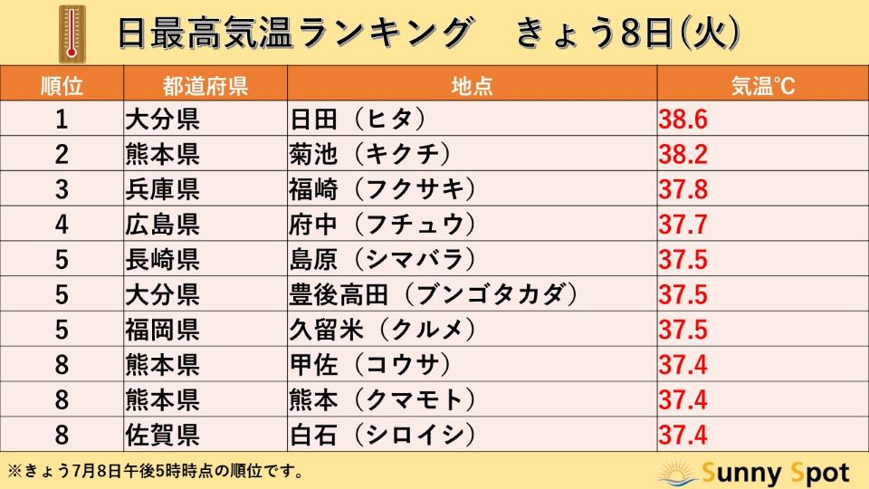
As of 5pm today, the number of midsummer observation points was 762, and the number of extremely hot spots was 162. It was a hot day, mainly in western Japan, and in the rankings at the Amedas observation sites at 5pm, the top 10 locations recorded a maximum temperature of 37 C or higher, making it a dangerous heat that exceeds body temperature. The temperature was 36.3 C in Otacho, Kitahiroshima-cho, Hiroshima Prefecture, and 36.4 C in Higashiichiriki, Hioki City, Kagoshima Prefecture, which set a new record high.
In Eastern Japan, the daytime high temperature reached 35.8 C in central Tokyo, marking record-breaking heat, breaking the highest temperature this year.
#Maximum temperature in major cities
Sapporo: 29.2c (over the hottest season)
Sendai: 33.1c (over the hottest season)
*Tokyo: 35.8c (over the hottest season)
Nagoya: 34.8c (over the hottest season)
Osaka: 34.1c (regularly early August)
Fukuoka: 33.2c (regularly early August)
Naha: 31.9c (regularly mid-July)
*: Highest temperatures this year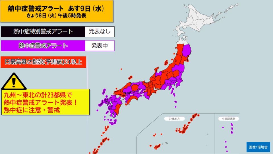
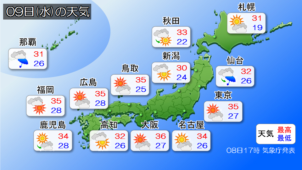
Tomorrow, the 9th (Wednesday), will be around 35 C, mainly in western Japan to eastern Japan, with many places likely to be extremely hot.
The heatstroke warning alert for tomorrow, the 9th (Wednesday) has been announced for a total of 23 prefectures from Kyushu to Tohoku, making this the first announcement this year in Fukushima and Iwate prefectures. Morioka's highest temperature is 35 C, and the forecast is expected to be extremely hot in the hot days, while Kyoto and Okayama are expected to be 37 C, which could lead to dangerous heat that exceeds body temperature. Additionally, the lowest temperature tomorrow morning will be above 25 C over a wide range, making it likely to become a tropical night in many areas.
This increases the risk of heat stroke, so be sure to drink plenty of hydration and salt, and take appropriate breaks. Also, the temperatures will continue to be high even at night, so use air conditioning both day and night to prevent heat stroke at night.